


Unofficial guide. Not the National Monuments Service, the OPW, Fáilte Ireland or the landowner. Disclaimer
At a glance
- TypeOgham stone
What to look for
- Ogham inscription
Picked out from the Archaeological Survey description below.
Can you visit?
- No source says it is open to the public.Most monuments in Ireland stand on private farmland.
- Ask the landowner before crossing fields, close gates, leave the stones as you find them.Visiting responsibly
History and description
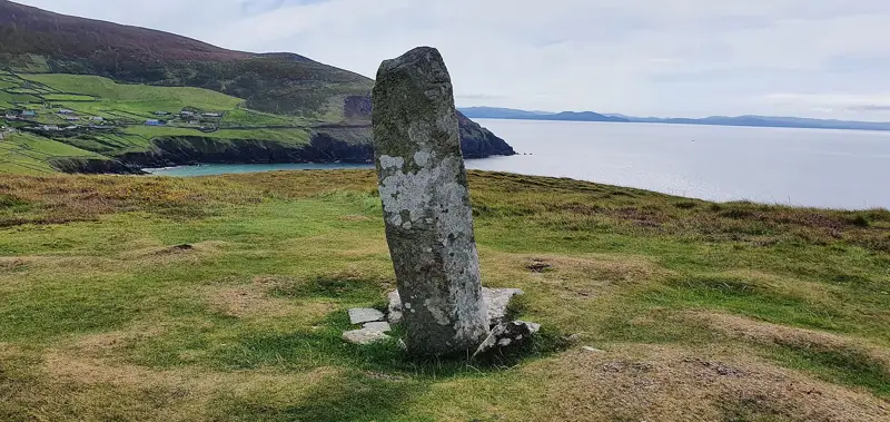
One of two ogham stones located at Cnoc na Fola, a low, sub-rectangular cairn located on the low ridge overlooking Minard to the south. The level field in which it occurs is named Páirc na Fola and was traditionally the scene of a bloody battle in ancient times.
Full archaeological record 158 words
One of two ogham stones located at Cnoc na Fola, a low, sub-rectangular cairn located on the low ridge overlooking Minard to the south. The level field in which it occurs is named Páirc na Fola and was traditionally the scene of a bloody battle in ancient times. The cairn reputedly marks the graves of those slain. The cairn material is a mixture of earth and stones many of which are quartz. Four low standing stones occur along the perimeter and 3 further prostrate slabs may formerly have stood upright. Two of the standing stones bear ogham inscriptions. This rounded boulder (see also KE054-033004-), measuring .8m high and 1.3m in circumference, bears the inscription: GOSSUCTTIAS (Macalister 1945, 183, no. 190). (Cuppage 1986, no. 807)
This stone has been studied as part of the ‘Ogham in 3D’ project undertaken by the School of Celtic Studies, Dublin Institute for Advanced Studies. To access details go to the following website:
https://ogham.celt.dias.ie/search.php?ciic=190
Archaeological Survey of Ireland, National Monuments Service (CC BY 4.0) · Compiled by Nora White · Updated 31 January 2017. It describes the site as it was when surveyed.
Folklore and traditions
The level field in which it occurs is named Páirc na Fola and was traditionally the scene of a bloody battle in ancient times.
The cairn reputedly marks the graves of those slain.
More ogham stones nearby

Ballintaggart Ogham Stones
Ogham stone · Baile An Tsagairt (Tc Na Gleannta) · Kerry · 7.7 km away
 National Monument
Ballinrannig Stone
Ogham stone · Baile An Reannaigh · Kerry · 18 km away
 National Monument
Ogham Stone Coumeenole North / Dunmore Head, Co. Kerry
Ogham stone · Com Dhíneol Thuaidh · Kerry · 24 km away
Kilcoolaght East ogham stones
Ogham stone · Kilcoolaght East · Kerry · 27 km away
Visitors' notes
Badges are opinions of visitors - not verified facts. One vote per badge and visitor; no account needed.
Best time to visit
What's missing on this page?
Share a tip to find it
Share a local tradition or story
Suggest a correction
Suggest the right map location
Report a duplicate page
Ask a question
Do not include personal data. See our privacy notice.
Around Cnoc na Fola ogham stones
Other heritage nearby
- Graigue Standing StoneStanding stone · 1.0 km
- St Johns Well - Tobar EoinHoly well · 1.8 km
- Minard CastleCastle · 1.8 km
- Doonmanagh Wedge tombMegalithic tomb · 1.9 km
- TobermurryHoly well · 5.0 km
- ToberaroonHoly well · 7.1 km
Recorded within 5 km
- 83 ringfortsArchaeological Survey of Ireland
- 19 standing stonesArchaeological Survey of Ireland
- 9 ogham stonesArchaeological Survey of Ireland
- 7 ancient churchesArchaeological Survey of Ireland
- 4 holy wellsArchaeological Survey of Ireland
- 4 promontory fortsArchaeological Survey of Ireland
- 3 megalithic tombsArchaeological Survey of Ireland
- 2 monastic sitesArchaeological Survey of Ireland
- 1 castleArchaeological Survey of Ireland
Walks and trails
- Dingle WayLong Distance Waymarked Way · 163.0 km · nearest point 0.7 km
- Meelin Hill Looped Walk /Lúbshiúlóid na MaoilinneWalking Trail · 7.8 km · nearest point 5.4 km
- Glanteenassig - Lough CaumWalking Trail · 1.7 km · nearest point 9.3 km
Outdoors, towns and places to stay
- GlanteenassigForests · 11 km
- InchBeaches · 10 km · Excellent Quality (2025)
- KellsBeaches · 12 km · Excellent Quality (2025)
- Castlemaine Harbour Nature ReserveNature reserves · 13 km
- Mount Brandon Nature ReserveNature reserves · 16 km
- DingleWalled towns · 9.3 km
Other attractions nearby
- Minard CastleHistoric Houses and Castle · 1.8 km
- Kinard BeachNatural Landscape · 5.4 km
- Doonshean BeachNature and Wildlife · 6.1 km
- An Chonair (Conor Pass)Natural Landscape · 7.3 km
What's on nearby
- Dingle Literary Festival 20262026-11-20 · 9.6 km
- Dingle Literary Festival 20262026-11-21 · 9.6 km
- Dingle Literary Festival 20262026-11-22 · 9.6 km