


Unofficial guide. Not the National Monuments Service, the OPW, Fáilte Ireland or the landowner. Disclaimer
At a glance
- TypeOgham stone
- Date or period mentioned1839
- StatusNational Monument
What to look for
- Ogham inscription
Picked out from the Archaeological Survey description below.
Can you visit?
- No source says it is open to the public.Most monuments in Ireland stand on private farmland.
- Ask the landowner before crossing fields, close gates, leave the stones as you find them.Visiting responsibly
History and description
Dunmore/An Dún Mór: This large headland, rising 328 feet/100m OD, projects W into the Blasket Sound at the extreme W tip of the Dingle Peninsula.
Full archaeological record 118 words
Dunmore/An Dún Mór: This large headland, rising 328 feet/100m OD, projects W into the Blasket Sound at the extreme W tip of the Dingle Peninsula.
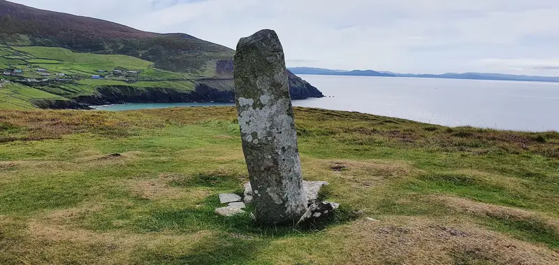
An ogham stone stands upright on the summit of the headland. This lay prostrate when first recorded (Windele 1838, 153), but was subsequently re-erected (Chatterton 1839, 187). It stands 2m high and is .45m wide x c. 0.3m thick. The inscription reads: ERC MAQI MAQI-ERCIAS (MU) DOVINI(A). The second last word, as recorded by Macalister (1945, 171), is now unclear. The final A is not visible either, but is included in most earlier accounts. Westropp (1910, 291) suggests that Dunmore may have been a place of ritual, a sanctuary of the goddess Duibhne.
References
- This stone has been studied as part of the ‘Ogham in 3D’ project undertaken by the School of Celtic Studies, Dublin Institute for Advanced Studies. To access details go to the following website: http://ogham.celt.dias.ie/search.php?ciic=178
- This monument is subject to a preservation order made under the National Monuments Acts 1930 to 2014 (PO no. 1/2004).
Archaeological Survey of Ireland, National Monuments Service (CC BY 4.0) · Compiled by Paul Walsh · Updated 2 January 2015 · Based on the J. Cuppage, ‘Corca Dhuibhne. Dingle Peninsula archaeological survey. Ballyferriter. Oidhreacht Chorca Dhuibhne. It describes the site as it was when surveyed.
More ogham stones nearby
 National Monument
Ballinrannig Stone
Ogham stone · Baile An Reannaigh · Kerry · 9.6 km away

Ballintaggart Ogham Stones
Ogham stone · Baile An Tsagairt (Tc Na Gleannta) · Kerry · 16 km away

Cnoc na Fola ogham stones
Ogham stone · Log Na Gcapall · Kerry · 24 km away
Visitors' notes
Badges are opinions of visitors - not verified facts. One vote per badge and visitor; no account needed.
Best time to visit
What's missing on this page?
Share a tip to find it
Share a local tradition or story
Suggest a correction
Suggest the right map location
Report a duplicate page
Ask a question
Do not include personal data. See our privacy notice.
Around Ogham Stone Coumeenole North / Dunmore Head, Co. Kerry
Other heritage nearby
- Dunquin Old ChurchAncient church · 3.2 km
- Caher ConorRingfort · 3.6 km
- TobermurryHoly well · 4.1 km
- Dunbeg FortPromontory fort · 4.5 km
- Ballywiheen ChurchAncient church · 7.0 km
- Rahinnane CastleCastle · 7.1 km
Recorded within 5 km
- 22 ringfortsArchaeological Survey of Ireland
- 10 standing stonesArchaeological Survey of Ireland
- 6 megalithic tombsArchaeological Survey of Ireland
- 5 ancient churchesArchaeological Survey of Ireland
- 3 promontory fortsArchaeological Survey of Ireland
- 3 holy wellsArchaeological Survey of Ireland
- 1 castleArchaeological Survey of Ireland
- 1 ogham stoneArchaeological Survey of Ireland
Walks and trails
- Dingle WayLong Distance Waymarked Way · 163.0 km · nearest point 0.8 km
- Dingle - Siúlóid na CilleWalking Trail · 4.5 km · nearest point 2.3 km
- Dingle - Cosan Cuas na nEigheWalking Trail · 2.8 km · nearest point 5.2 km
Outdoors, towns and places to stay
- Fionntrá (Ventry)Beaches · 7.8 km · Excellent Quality (2025)
- Béal BánBeaches · 9.1 km
- Tearaght Island Nature ReserveNature reserves · 14 km
- Tearaght Island Nature ReserveNature reserves · 14 km
- DingleWalled towns · 14 km
Other attractions nearby
- Radharc na mBlascaodaí (Blaskets View)Nature and Wildlife · 1.3 km
- Ceann Sléibhe (Slea Head)Natural Landscape · 1.3 km
- Cé Dhún Chaoin (Dunquin Pier)Historic Houses and Castle · 1.8 km
- Dingle Film WalksWalking · 2.6 km
What's on nearby
- Dingle Literary Festival 20262026-11-20 · 14 km
- Dingle Literary Festival 20262026-11-21 · 14 km
- Dingle Literary Festival 20262026-11-22 · 14 km