


Unofficial guide. Not the National Monuments Service, the OPW, Fáilte Ireland or the landowner. Disclaimer
At a glance
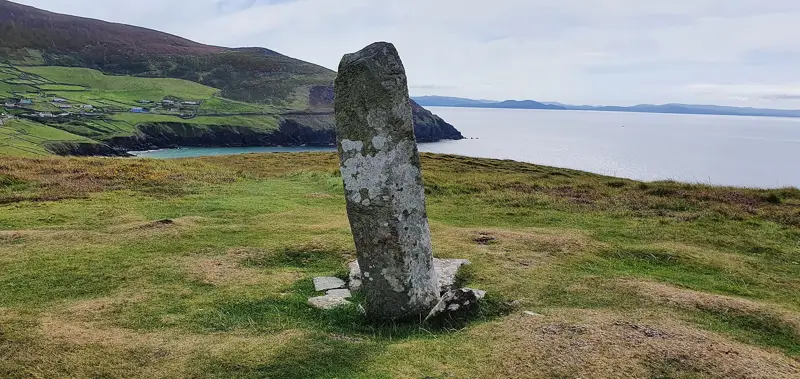
- TypeOgham stone
- Date or period mentioned18th century
- Condition (as surveyed)Ruined
- StatusNational Monument
What to look for
- Ogham inscription
- Cross carved
Picked out from the Archaeological Survey description below.
Can you visit?
- No source says it is open to the public.Most monuments in Ireland stand on private farmland.
- Ask the landowner before crossing fields, close gates, leave the stones as you find them.Visiting responsibly
History and description
Cillvickillane/Cill Mhic Uíleáin: A storm at the end of the 18th century exposed 7 ogham stones, this possible fragment of an 8th ogham stone, a cross-inscribed stone, a number of graves and quantities of bone, and the ruins of several houses (Windele 1838, 145). Windele's sketch of the site shows the ogham stones set out in a rough semi-circle on top of the mound with a slab-lined grave positioned nearby.
Full archaeological record 197 words
Cillvickillane/Cill Mhic Uíleáin: A storm at the end of the 18th century exposed 7 ogham stones, this possible fragment of an 8th ogham stone, a cross-inscribed stone, a number of graves and quantities of bone, and the ruins of several houses (Windele 1838, 145). Windele's sketch of the site shows the ogham stones set out in a rough semi-circle on top of the mound with a slab-lined grave positioned nearby. Lord Ventry removed 6 of the ogham stones from the site in the mid-19th century; nos. 1 to 4 now line the driveway to Burnham House/Colaiste Íde (KE053-012004-, KE053-012005-, KE053-012006-, KE053-012007-), between Dingle and Ventry; nos. 5 and 6 are preserved in the grounds of Chute Hall (KE027-132----, KE027-241----) near Tralee and no. 7 remains at the original site (KE042-057003-).
The present location of this stone is at Chute Hall in the townland of Tullygarran and its monument number at that location is KE027-241----. A stone measuring 1.1m high and 0.29 x 0.20m at base. Two opposed angles bear the inscription: CCICAMINI MAQQ(I) C(A)TTINI. Two of the vowels are no longer traceable but the remainder of the scores are clearly defined. (Cuppage 1986, no. 792 (No. 6))
References
- To see a 3D model of this monument, visit; https://skfb.ly/6yxQA
Archaeological Survey of Ireland, National Monuments Service (CC BY 4.0) · Compiled by Nora White · Updated 30 November 2016. It describes the site as it was when surveyed.
More ogham stones nearby
 National Monument
Ogham Stone Coumeenole North / Dunmore Head, Co. Kerry
Ogham stone · Com Dhíneol Thuaidh · Kerry · 9.6 km away

Ballintaggart Ogham Stones
Ogham stone · Baile An Tsagairt (Tc Na Gleannta) · Kerry · 11 km away

Cnoc na Fola ogham stones
Ogham stone · Log Na Gcapall · Kerry · 18 km away
Visitors' notes
Badges are opinions of visitors - not verified facts. One vote per badge and visitor; no account needed.
Best time to visit
What's missing on this page?
Share a tip to find it
Share a local tradition or story
Suggest a correction
Suggest the right map location
Report a duplicate page
Ask a question
Do not include personal data. See our privacy notice.
Around Ballinrannig Stone
Other heritage nearby
- Reask Monastic SiteMonastic site · 1.3 km
- Gallarus CastleCastle · 2.2 km
- Ballywiheen ChurchAncient church · 2.6 km
- Gallarus monastic siteMonastic site · 2.7 km
- Gallarus OratoryAncient church · 2.7 km
- Caherdorgan NorthRingfort · 3.3 km
Recorded within 5 km
- 38 ringfortsArchaeological Survey of Ireland
- 19 standing stonesArchaeological Survey of Ireland
- 16 holy wellsArchaeological Survey of Ireland
- 15 ancient churchesArchaeological Survey of Ireland
- 14 promontory fortsArchaeological Survey of Ireland
- 11 ogham stonesArchaeological Survey of Ireland
- 10 monastic sitesArchaeological Survey of Ireland
- 4 castlesArchaeological Survey of Ireland
- 2 megalithic tombsArchaeological Survey of Ireland
- 1 high crossArchaeological Survey of Ireland
Walks and trails
- Dingle WayLong Distance Waymarked Way · 163.0 km · nearest point 0.1 km
- Dingle - Siuloid na FailleWalking Trail · 4.9 km · nearest point 1.5 km
- Cosan na Naomh (Saints Road)Pilgrim Path · 17.7 km · nearest point 2.2 km
Outdoors, towns and places to stay
- Béal BánBeaches · 1.3 km
- Fionntrá (Ventry)Beaches · 5.6 km · Excellent Quality (2025)
- Mount Brandon Nature ReserveNature reserves · 14 km
- DingleWalled towns · 9.3 km
Other attractions nearby
- Béal Bán BeachBeach · 1.4 km
- Murreagh BeachNatural Landscape · 2.0 km
- Dún An ÓirHistoric Houses and Castle · 2.2 km
- Gallarus Oratory Visitor CentreMuseums and Attraction · 2.7 km
What's on nearby
- Dingle Literary Festival 20262026-11-20 · 9.0 km
- Dingle Literary Festival 20262026-11-21 · 9.0 km
- Dingle Literary Festival 20262026-11-22 · 9.0 km