
Unofficial guide. Not the National Monuments Service, the OPW, Fáilte Ireland or the landowner. Disclaimer
At a glance
- TypeStone circle - five-stone
- StatusNational Monument
What to look for
- Stones still standing
Picked out from the Archaeological Survey description below.
Can you visit?
- No source says it is open to the public.Most monuments in Ireland stand on private farmland.
- Ask the landowner before crossing fields, close gates, leave the stones as you find them.Visiting responsibly
History and description
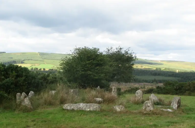
On level shoulder on SE-facing slope of Mealagh river valley. Circle complete; N entrance stone prostrate.
Full archaeological record 72 words
On level shoulder on SE-facing slope of Mealagh river valley. Circle complete; N entrance stone prostrate. Orthostats are 1m to 1.2m L, 0.5m T and 1m to 1.2m H. Beside and to S is spread of stones c. 8m in diameter; possible field clearance. Standing stone (CO106-057---) c. 26m to S. (WBBS). Myler (1998, 37) records that the 'stone circle is situated within a small area enclosed by ditches on three sides'.
Archaeological Survey of Ireland, National Monuments Service (CC BY 4.0) · Updated 24 January 2013 · Based on the Archaeological Inventory of County Cork. Volume 1: West Cork. It describes the site as it was when surveyed.
More stone circles nearby
Dromagorteen Stone Circle
Stone circle - multiple-stone · Dromagorteen · Kerry · 15 km away
Dunbeacon stone circle
Stone circle - multiple-stone · Dunbeacon · Cork · 19 km away
Knockawaddra stone circle
Stone circle - five-stone · Lettergorman · Cork · 22 km away
Visitor site National MonumentDrombeg Stone Circle
Stone circle - multiple-stone · Drombeg (Carbery E. (W.D.) By.) · Cork · 27 km away
Also recorded nearby
Named sites within 5 km with only a short entry in the Archaeological Survey.
- TobermurryRitual site - holy well · Lisheen (Bantry By.) · 2.4 km · official record
In pasture, just S of Kilmocomoge graveyard (CO105-013002-) and close to stream. Still in holy use, now contained by concrete surround with railings on top. Adorned with numerous statues.
Visitors' notes
Badges are opinions of visitors - not verified facts. One vote per badge and visitor; no account needed.
Best time to visit
What's missing on this page?
Share a tip to find it
Share a local tradition or story
Suggest a correction
Suggest the right map location
Report a duplicate page
Ask a question
Do not include personal data. See our privacy notice.
Around Derryarkane Stone Circle
Other heritage nearby
- St Brigid's WellHoly well · 2.5 km
- O'Donovan's CastleCastle · 7.4 km
Recorded within 5 km
- 33 ringfortsArchaeological Survey of Ireland
- 32 standing stonesArchaeological Survey of Ireland
- 5 stone circlesArchaeological Survey of Ireland
- 3 holy wellsArchaeological Survey of Ireland
- 3 megalithic tombsArchaeological Survey of Ireland
- 2 ancient churchesArchaeological Survey of Ireland
- 1 castleArchaeological Survey of Ireland
- 1 promontory fortArchaeological Survey of Ireland
- 1 ogham stoneArchaeological Survey of Ireland
Walks and trails
- Sheep's Head - Mealagh Valley LoopWalking Trail · 10.9 km · nearest point 1.4 km
- Sheep's Head - Mullaghmesha LoopWalking Trail · 10.4 km · nearest point 1.4 km
- Sheep's Head WayLong Distance Waymarked Way · 171.7 km · nearest point 1.8 km
Outdoors, towns and places to stay
- Gougane Barra Forest ParkForests · 12 km
- Gougane Barra Forest ParkForests · 12 km
- Glengarriff Wood Nature ReserveNature reserves · 14 km
- Muxnaw LodgeHistoric stays · 21 km
Other attractions nearby
- The Wild Sky DomeNature and Wildlife · 1.4 km
- O'Donovan's CastleHistoric Houses and Castle · 7.4 km
- West Cork MusicAttraction · 7.4 km
- Bantry HarbourNatural Landscape · 8.1 km
What's on nearby
- Romantic Masters with Vanbrugh & Friends2026-11-15 · 7.6 km