
Unofficial guide. Not the National Monuments Service, the OPW, Fáilte Ireland or the landowner. Disclaimer
At a glance
- TypeStone circle - multiple-stone
What to look for
- Recumbent stone
- Stones still standing
Picked out from the Archaeological Survey description below.
Can you visit?
- No source says it is open to the public.Most monuments in Ireland stand on private farmland.
- Ask the landowner before crossing fields, close gates, leave the stones as you find them.Visiting responsibly
History and description
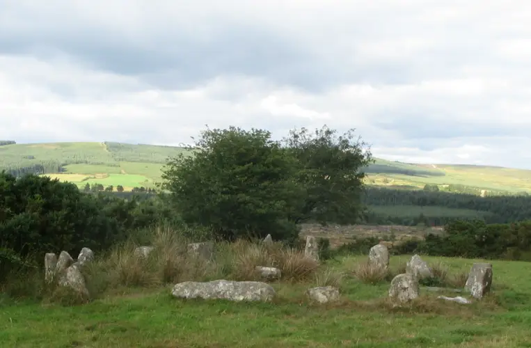
In Bonane Heritage Park, on a break on a SW-facing slope. A circle (diam. 10m) of probably thirteen stones, six of which are upright.
Full archaeological record 91 words
In Bonane Heritage Park, on a break on a SW-facing slope. A circle (diam. 10m) of probably thirteen stones, six of which are upright. The stones measure L 0.75-1.55m; T 0.4-0.8m and H 0.8-1.4m. One of the entrance stones at the NNE, a quartz-veined boulder, has fallen. The other entrance stone (1m x 0.8m; H 1.4m) is the tallest stone. The flat-topped axial stone (1.6m x 0.8m; H 0.8m) stands at SSW. A boulder-burial (KE102-032003-) occupies the centre of the interior. A fulacht fia (KE102-032004-) lies c. 25m to the E.
Archaeological Survey of Ireland, National Monuments Service (CC BY 4.0) · Updated 30 May 2011 · Based on the Archaeological Inventory of County Kerry. Volume I: South-West Kerry. It describes the site as it was when surveyed.
More stone circles nearby
Derryarkane Stone Circle
Stone circle - five-stone · Derryarkane · Cork · 15 km away
Dunbeacon stone circle
Stone circle - multiple-stone · Dunbeacon · Cork · 26 km away
Visitors' notes
Badges are opinions of visitors - not verified facts. One vote per badge and visitor; no account needed.
Best time to visit
What's missing on this page?
Share a tip to find it
Share a local tradition or story
Suggest a correction
Suggest the right map location
Report a duplicate page
Ask a question
Do not include personal data. See our privacy notice.
Around Dromagorteen Stone Circle
Other heritage nearby
- Feagha ChurchAncient church · 1.5 km
- TobernawahneeHoly well · 3.7 km
- Holy Cross ChurchAncient church · 7.1 km
- TobermurryHoly well · 7.6 km
- Kilgarvan ChurchAncient church · 9.5 km
Recorded within 5 km
- 22 ringfortsArchaeological Survey of Ireland
- 10 standing stonesArchaeological Survey of Ireland
- 8 megalithic tombsArchaeological Survey of Ireland
- 2 holy wellsArchaeological Survey of Ireland
- 2 stone circlesArchaeological Survey of Ireland
- 1 ancient churchArchaeological Survey of Ireland
- 1 monastic siteArchaeological Survey of Ireland
Walks and trails
- Sheen Valley Cycle Trails - Heritage TrailRoad Cycling Trail · 16.4 km · nearest point 0.7 km
- Sheen Valley Cycle Trails - Priest's LeapRoad Cycling Trail · 57.5 km · nearest point 1.0 km
- Beara WayLong Distance Waymarked Way · 241.9 km · nearest point 1.0 km
Outdoors, towns and places to stay
- Gougane Barra Forest ParkForests · 12 km
- Gougane Barra Forest ParkForests · 12 km
- Glengarriff Wood Nature ReserveNature reserves · 9.8 km
- Uragh Wood Nature ReserveNature reserves · 12 km
- Muxnaw LodgeHistoric stays · 6.5 km
Other attractions nearby
- Beara Outdoor AdventuresWalking · 0.2 km
- Bonane Heritage ParkMuseums and Attraction · 0.6 km
- Knockboy and Priest's LeapNatural Landscape · 5.0 km
- Kenmare Bay Boat ToursNature and Wildlife · 7.0 km
What's on nearby
- Design Kenmare 20262026-11-13 · 7.4 km
- Design Kenmare 20262026-11-14 · 7.4 km
- Design Kenmare 20262026-11-15 · 7.4 km