
Unofficial guide. Not the National Monuments Service, the OPW, Fáilte Ireland or the landowner. Disclaimer
At a glance
- TypeStone circle - multiple-stone
- Date or period mentioned1124
- StatusNational Monument
What to look for
- Recumbent stone
- Portal stones
- Stones still standing
- Alignment
Picked out from the Archaeological Survey description below.
Visiting
- National Monument in State care, listed by the National Monuments Service as a monument to visit.NMS Monuments to Visit · official page
- May be on private land and not open to the publicNational Monuments Service advice
- Wear suitable footwear and clothingNational Monuments Service advice
- Uneven ground: not suitable for everyone, especially wheelchair usersNational Monuments Service advice
Opening times and fees change: check with the operator before you go.
About Drombeg Stone Circle
- c. 1500 BCStone circles were places of ritual and ceremony in the later Bronze Age period (c. 1500…
- 800 BCRadiocarbon dating has placed the burial in the period c. 1100-800 BC.
- 600 BCStone circles were places of ritual and ceremony in the later Bronze Age period (c. 1500…
- 1957Excavations undertaken in 1957 revealed a central pit that contained a pottery vessel…
Its history
- Stone circles were places of ritual and ceremony in the later Bronze Age period (c. 1500 BC - 600 BC) and were usually associated with human burial.
- Excavations undertaken in 1957 revealed a central pit that contained a pottery vessel covering the cremated remains of a youth.
- Radiocarbon dating has placed the burial in the period c. 1100-800 BC.
What you'll see
- Drombeg stone circle is dramatically situated on a rocky terrace with sweeping views over farmland to the Atlantic Ocean.
- Drombeg is perhaps the finest example of a distinctive series of stone circles found in Cork and Kerry.
- Also at the site is a fulacht fiadh or prehistoric cooking site.
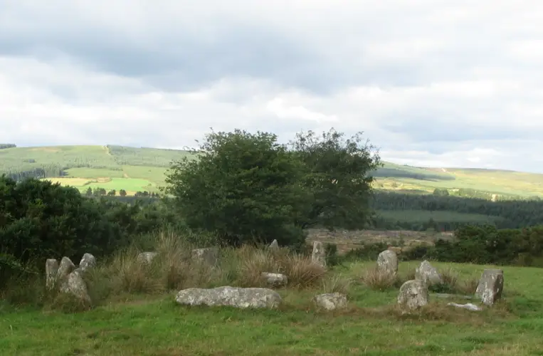
- Stone circle - At Drombeg the seventeen stones are symmetrically arranged so that one of the stones (the axial stone) is set on its side and placed directly opposite a pair of tall stones (the portal stones) that form the entrance to the circle.
- The stones reduce in height from the portals to the axial stone which has two shallow cup marks carved on its upper surface.
- In common with many stone circles in the region, the axis of the circle (i.e., the line extending through the entrance across the top of the axial stone) is orientated north-east / south-west.
- At the winter solstice (21st December) the sun sets at a point on the horizon aligned with this axis.
- This marks of the shortest day of the year in Ireland.
- Fulacht fiadh - Very close to the stone circle are the remains of two hut sites and a fulacht fiadh (ancient cooking place).
- The fulacht fiadh consists of a stone-lined trough with a nearby hearth and well.
- Water in the trough would have been heated by rolling in stones heated by fire in the hearth.
- Experiments have shown that in about 18 minutes, 70 gallons (318 litres) of cold water could be brought to the boil in this way.
- Meat was then cooked in the water, which remained sufficiently hot for almost 3 hours.
- Alternative suggested uses for fulachtaí fia are ritual bathing, as well as industrial activities such as dyeing and even brewing.
Text: National Monuments Service, Monuments to Visit (CC BY 4.0). Sentences grouped by topic by ErinSites; the wording is unchanged.
History and description
Full archaeological record 239 words
In pasture on a natural rock terrace on the S slope of a low hill. This stone circle was excavated in 1957 (Fahy 1959, 1-27), and the nearby fulacht fiadh (CO143-051002-) and hut site (CO143-051001-) in 1958 (Fahy 1960, 1-17). The circle consisted of seventeen stones; two are missing and one has fallen. The stones are 0.55m to 2.05m L, 0.2m to 0.65m T and 1.1m to 2.05m H. On the upper surface of the axial stone, which is the largest stone in the circle, are two shallow cup-marks, one surrounded by an oval carving. The internal measurement along the main axis, aligned NE-SW, is 9m. Five pits were found within the circle, sealed beneath compacted gravel floor; one pit contained the deposit of cremated human bone, fragments of shale and numerous sherds of coarse fabric pot. Initial radiocarbon dating of the charcoal from the burial returned as BC 13 ± 140 (Fahy 1960, 17), which was later amended to AD 600 ± 120 (D-62) which is 'clearly anomalous' (O Nualláin 1984a, 10). However, a more recent analysis of the charcoal from the grave returned a date range of 1124-794 BC (Waddell 1998, 169), making it a lot older than first thought. Other finds from the circle included seven pieces of flint, including a small convex scraper. (O Nualláin 1984a, 24. no. 37; Roberts 1988, Ch. 2, no. 5)
This is a National Monument in State Guardianship (no. 381).
References
- Date of last revision: 27 June 2023
Archaeological Survey of Ireland, National Monuments Service (CC BY 4.0) · Updated 14 January 2009 · Based on the Archaeological Inventory of County Cork. Volume 1: West Cork. It describes the site as it was when surveyed.
More stone circles nearby
Knockawaddra stone circle
Stone circle - five-stone · Lettergorman · Cork · 11 km away
National MonumentDerryarkane Stone Circle
Stone circle - five-stone · Derryarkane · Cork · 27 km away
Also recorded nearby
Named sites within 5 km with only a short entry in the Archaeological Survey.
- ToberbreedyRitual site - holy well · Tralong · 2.1 km · official record
In pasture, on W-facing slope. Built into slope; stone-lined surround with lintelled stone cover. No longer in holy use.
Visitors' notes
Badges are opinions of visitors - not verified facts. One vote per badge and visitor; no account needed.
Best time to visit
What's missing on this page?
Share a tip to find it
Share a local tradition or story
Suggest a correction
Suggest the right map location
Report a duplicate page
Ask a question
Do not include personal data. See our privacy notice.
Around Drombeg Stone Circle
Other heritage nearby
- Coppinger's CourtCastle · 1.6 km
- St Bridget's WellHoly well · 4.6 km
- Raheen CastleCastle · 6.2 km
- Knockdrum Stone FortRingfort · 8.5 km
Recorded within 5 km
- 42 ringfortsArchaeological Survey of Ireland
- 8 standing stonesArchaeological Survey of Ireland
- 6 ancient churchesArchaeological Survey of Ireland
- 6 castlesArchaeological Survey of Ireland
- 5 promontory fortsArchaeological Survey of Ireland
- 5 holy wellsArchaeological Survey of Ireland
- 1 monastic siteArchaeological Survey of Ireland
- 1 abbey or friaryArchaeological Survey of Ireland
- 1 megalithic tombArchaeological Survey of Ireland
Walks and trails
- EuroVelo 1 Ireland - Atlantic Coast RouteRoad Cycling Trail · 2365.5 km · nearest point 0.6 km
- Cellmount LoopWalking Trail · 1.5 km · nearest point 3.0 km
- Union Hall Walks - Reen WalkWalking Trail · 5.7 km · nearest point 3.7 km
Outdoors, towns and places to stay
- DromillihyForests · 3.3 km
- RineenForests · 5.9 km
- Warren, Cregane StrandBeaches · 5.1 km · Good Quality (2025)
- Owenahincha, Little Island StrandBeaches · 6.5 km · Excellent Quality (2025)
- Lough Hyne Nature ReserveNature reserves · 17 km
- Knockomagh Wood Nature ReserveNature reserves · 17 km
- RosscarberyWalled towns · 4.0 km
- Galley Head Lightkeeper's House 1Historic stays · 10 km
- Galley Head Lightkeeper's House 2Historic stays · 10 km
Other attractions nearby
- Coppinger's CourtHistoric Houses and Castle · 1.6 km
- Christ Church - GlandoreHistoric Houses and Castle · 2.5 km
- Seaside AlpacasNature and Wildlife · 4.2 km
- Ireland's WildlifeNature and Wildlife · 4.3 km