

Unofficial guide. Not the National Monuments Service, the OPW, Fáilte Ireland or the landowner. Disclaimer
At a glance
- TypeStanding stone
- Recorded size1.65m x 0.55m; H 2.6m
What to look for
- Standing upright
- Packing stones
Picked out from the Archaeological Survey description below.
Can you visit?
- No source says it is open to the public.Most monuments in Ireland stand on private farmland.
- Ask the landowner before crossing fields, close gates, leave the stones as you find them.Visiting responsibly
History and description
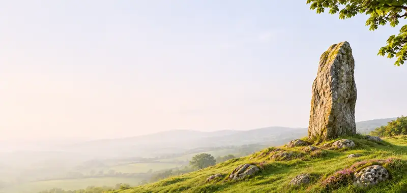
On a gentle WSW-facing slope, overlooking the valley of the Lingaun River to the SW, in pasture. A cairn (TS078-001----) is visible on Slievenamon c. 7km due W. An upright stone (1.65m x 0.55m; H 2.6m) of red sandstone, orientated NE-SW and tapering to a point.
Full archaeological record 92 words
On a gentle WSW-facing slope, overlooking the valley of the Lingaun River to the SW, in pasture. A cairn (TS078-001----) is visible on Slievenamon c. 7km due W. An upright stone (1.65m x 0.55m; H 2.6m) of red sandstone, orientated NE-SW and tapering to a point. The stone is sub-rectangular in plan with natural cleavage plains and sub-circular depressions on the NW and SW sides. There are possible packing stones at the base. According to Power (1908, 200) the stone was incorporated into field fence. This field fence has subsequently been removed.
Archaeological Survey of Ireland, National Monuments Service (CC BY 4.0) · Compiled by Jean Farrelly · Updated 26 August 2011. It describes the site as it was when surveyed.
More standing stones nearby


Also recorded nearby
Named sites within 5 km with only a short entry in the Archaeological Survey.
- TobernagloghlinRitual site - holy well · Kiltrassy · 3.7 km · official record
- TobernarahaRitual site - holy well · Knockroe (Kells By., Killamery Ed) · 4.0 km · official record
- Knockroe holy wellRitual site - holy well · Knockroe (Kells By., Killamery Ed) · 4.1 km · official record
- Church WellRitual site - holy well · Oldcastle Lower · 4.1 km · official record
Visitors' notes
Badges are opinions of visitors - not verified facts. One vote per badge and visitor; no account needed.
Best time to visit
What's missing on this page?
Share a tip to find it
Share a local tradition or story
Suggest a correction
Suggest the right map location
Report a duplicate page
Ask a question
Do not include personal data. See our privacy notice.
Around Ballinvir Standing Stone
Other heritage nearby
- Knockroe Passage TombMegalithic tomb · 4.1 km
- St. Crispin's Church (ruin)Ancient church · 4.9 km
- Ahenny High CrossesHigh cross · 4.9 km
- St. Nicholas's Well (Killamery)Holy well · 5.1 km
- Killamery High CrossHigh cross · 5.1 km
- Kilcash CastleCastle · 5.6 km
Recorded within 5 km
- 19 ringfortsArchaeological Survey of Ireland
- 9 standing stonesArchaeological Survey of Ireland
- 6 ancient churchesArchaeological Survey of Ireland
- 6 castlesArchaeological Survey of Ireland
- 4 holy wellsArchaeological Survey of Ireland
- 3 high crossesArchaeological Survey of Ireland
- 2 hillfortsArchaeological Survey of Ireland
- 1 megalithic tombArchaeological Survey of Ireland
Walks and trails
- Windgap - Bearna Breac LoopWalking Trail · 6.6 km · nearest point 4.2 km
- Windgap - Village LoopWalking Trail · 1.8 km · nearest point 5.3 km
- Tullahought - Kilmacoliver Summit LoopWalking Trail · 3.8 km · nearest point 6.4 km
Outdoors, towns and places to stay
- CastlemorrisForests · 12 km
- Garryricken Nature ReserveNature reserves · 8.0 km
- Kyleadohir Nature ReserveNature reserves · 11 km
- Carrick-on-SuirWalled towns · 10 km
- CallanWalled towns · 13 km
Other attractions nearby
- Walk With WalterWalking · 3.6 km
- Knockroe Passage TombHistoric Houses and Castle · 4.1 km
- Ahenny High CrossesHistoric Houses and Castle · 4.9 km
- Kilkieran High CrossAbbeys and Monastery · 6.5 km