

Unofficial guide. Not the National Monuments Service, the OPW, Fáilte Ireland or the landowner. Disclaimer
At a glance
- TypeStanding stone
- Recorded sizeH 1.55m; W 1.35m; T 0.6m
What to look for
- Standing upright
- Packing stones
Picked out from the Archaeological Survey description below.
Can you visit?
- No source says it is open to the public.Most monuments in Ireland stand on private farmland.
- Ask the landowner before crossing fields, close gates, leave the stones as you find them.Visiting responsibly
History and description
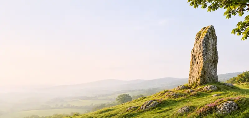
In pasture, on gentle SW-facing slope. This conglomerate upright (H 1.55m; Wth 1.35m; T 0.6m), oriented NW-SE, is firmly set in ground with some packing stones at base on SE-side.
Full archaeological record 67 words
In pasture, on gentle SW-facing slope. This conglomerate upright (H 1.55m; Wth 1.35m; T 0.6m), oriented NW-SE, is firmly set in ground with some packing stones at base on SE-side. It is slightly narrower at the base and the width increases towards the top of the stone. Some loose field clearance stones have been placed near it. The portal tomb (KK035-044----) stands c. 100m to the NE.
Archaeological Survey of Ireland, National Monuments Service (CC BY 4.0) · Compiled by Paul Walsh · Updated 7 April 2017. It describes the site as it was when surveyed.
More standing stones nearby


Also recorded nearby
Named sites within 5 km with only a short entry in the Archaeological Survey.
- Kilmogue ChurchChurch · Kilmogue · 0.3 km · official record
- Tree wellRitual site - holy well · Kilmogue · 0.3 km · official record
- ToberacluggeenRitual site - holy well · Milltown (Knocktopher By.) · 1.2 km · official record
- Well of the TreeRitual site - holy well · Garrygaug · 2.7 km · official record
- Oldcourt Church (site of)Church · Oldcourt (Iverk By.),Templeorum · 3.3 km · official record
- Easter WellRitual site - holy well · Redacres North · 4.2 km · official record
- Knockmoylan CastleCastle - unclassified · Knockmoylan · 4.3 km · official record
- Tubber a' TeampuillRitual site - holy well · Kilmanahin · 4.6 km · official record
Visitors' notes
Badges are opinions of visitors - not verified facts. One vote per badge and visitor; no account needed.
Best time to visit
What's missing on this page?
Share a tip to find it
Share a local tradition or story
Suggest a correction
Suggest the right map location
Report a duplicate page
Ask a question
Do not include personal data. See our privacy notice.
Around Kilmogue standing stone
Other heritage nearby
- Kilmogue Portal TombMegalithic tomb · 0.1 km
- Owning Portal TombMegalithic tomb · 5.4 km
- Tubbrid Portal TombMegalithic tomb · 6.8 km
- Aghaviller Round TowerRound tower · 6.9 km
- Aghaviller Church and CastleAncient church · 7.0 km
- Aghaviller Church and CastleCastle · 7.0 km
Recorded within 5 km
- 35 ringfortsArchaeological Survey of Ireland
- 11 standing stonesArchaeological Survey of Ireland
- 10 castlesArchaeological Survey of Ireland
- 7 ancient churchesArchaeological Survey of Ireland
- 6 megalithic tombsArchaeological Survey of Ireland
- 5 holy wellsArchaeological Survey of Ireland
- 1 monastic siteArchaeological Survey of Ireland
- 1 stone circleArchaeological Survey of Ireland
Walks and trails
- Pilltown - Mountain Grove LoopWalking Trail · 2.5 km · nearest point 3.8 km
- Castlemorris - Pheasant LoopWalking Trail · 7.0 km · nearest point 5.1 km
- South Leinster WayLong Distance Waymarked Way · 103.6 km · nearest point 5.6 km
Outdoors, towns and places to stay
- CastlemorrisForests · 5.2 km
- Fiddown Island Nature ReserveNature reserves · 9.3 km
- Garryricken Nature ReserveNature reserves · 15 km
- Carrick-on-SuirWalled towns · 12 km
Other attractions nearby
- Gáirdín an GhortaGardens · 8.0 km
- Kilkieran High CrossAbbeys and Monastery · 8.0 km
- Ahenny High CrossesHistoric Houses and Castle · 8.9 km
- Knockroe Passage TombHistoric Houses and Castle · 9.8 km
What's on nearby
- Waterford Winterval 20262026-11-13 · 19 km · free
- Children's Christmas Trail2026-11-13 · 19 km · free
- Waterford Winterval 20262026-11-14 · 19 km · free