


Unofficial guide. Not the National Monuments Service, the OPW, Fáilte Ireland or the landowner. Disclaimer
At a glance
- TypePromontory fort - coastal
- Date or period mentioned19th century
- Condition (as surveyed)Gone: no visible trace
- StatusNational Monument
What to look for
- Bank and ditch
- Souterrain
- Entrance gap
- Ramparts
Picked out from the Archaeological Survey description below.
Can you visit?
- No source says it is open to the public.Most monuments in Ireland stand on private farmland.
- Ask the landowner before crossing fields, close gates, leave the stones as you find them.Visiting responsibly
History and description
National Monument No. 177. Dunbeg/An Dún Beag: This small but impressive fort is located on a sheer cliff promontory which projects S into Dingle Bay at the base of Mount Eagle.
Full archaeological record 1,364 words
National Monument No. 177. Dunbeg/An Dún Beag: This small but impressive fort is located on a sheer cliff promontory which projects S into Dingle Bay at the base of Mount Eagle. It has suffered extensive erosion since it was first recorded in the early 19th century, and in 1977 the OPW initiated an excavation to try and reveal both the chronology and the nature of the occupational sequence of the site before much more of it was destroyed. The following description of the site is based, for the most part, on the report of that excavation (see Barry 1981, 295-329).
The defences consist of 4 lines of banks, 5 fosses, and an inner drystone rampart with a complex entrance flanked by 2 guard-chambers. A souterrain extends under the causeway from this entrance, and in the interior is a single clochaun.
The banks are raised up to 1m above old ground level and are up to 3m wide. The fosses are from .98 to 1.55m deep below the old ground surface and are from 5.6 to 12m wide. Portions of the 2 outer banks lie outside a boundary wall constructed in the 1890's, and their line is now barely perceptible. Several small breaks in the crests of the banks probably result from the removal of N-S field fences which formerly crossed the defences. Tentative traces of a palisade trench were found on the N facing crest of the inner bank and possibly along the N face of the next bank. There were also indications of possible stone facing on the N sides of both banks. A central causeway, 1.2m wide, provided access to the interior. Upright slabs lined the edges of this and a few of these still survive towards the S end.
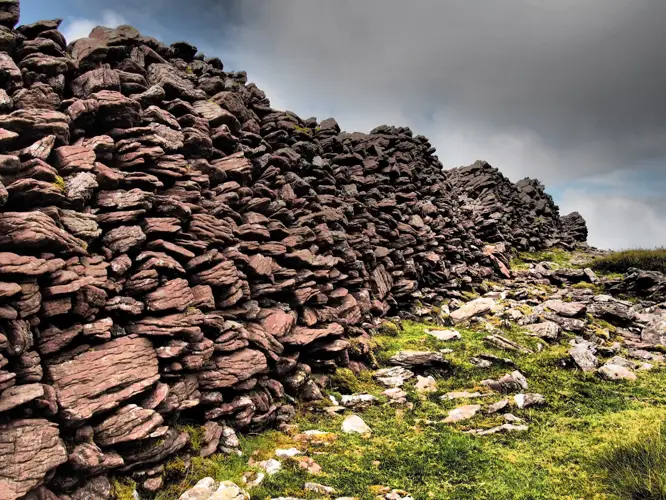
The inner stone rampart, up to 6.35m thick and 3.08m high, extends across the promontory for 29m. This is only about half the length recorded in 1856 by Du Noyer (1858, 2); much of the W half has fallen into the sea. There appear to have been 2 construction phases. Phase 1 is represented by the inner half of the wall; this measures 4.8m in width and 2.76m in height and has 3 terraces along its inner face. The lintelled entrance passage is 2m wide and 2.3m high with slightly corbelled side walls. Two small chambers are incorporated within the thickness of the wall on either side of this. They measure 2.3 x 1.4m x almost 2m high (E chamber) and 2.4 x 1m x 1.2m high (W chamber). One of these chambers was open at the top c. 1865, and must have been subsequently restored (Pitt-Rivers). Both are entered from the interior of the fort. Bolt holes for the wooden bar of a door across the entrance passage open into the chambers allowing access to the fort to be controlled by whomever was inside. At a later stage the exterior capstone of the passage cracked and pillars were inserted along the E side wall to give support. The passage was also extended outwards, but was reduced in width and height to .92m and 1.24m respectively. New bar holes were provided in the extended entrance, with external stone rebates for a wooden door. At the same time the adjacent fosse was deepened. The upcast soil was piled against the outer face of the rampart to form the core of a strengthening wall measuring 1.75 to 2.25m wide and 1.9m high. Because of the additional weight, the inner face of the fosse was buttressed with a drystone retaining wall. At present there is a curved terminal to the E end of the rampart and a similar terminal existed at the W end prior to its erosion. The chronological relationship between these and the main rampart remains uncertain. The earliest plans and descriptions of the site indicate a straight wall running from cliff edge to cliff edge (Du Noyer 1858; Pitt-Rivers c. 1865). Later field walls also extended along the edge of the promontory from each end of the rampart. Barry suggests the possibility that the workmen involved in reconstruction work in the 1890's may have mistaken the remains of these later walls for part of the original rampart and reconstructed them accordingly.
A drystone-built souterrain extends for 16.5m from within the entrance passage to some 2m S of the inner face of bank 2. For most of its length it measures 1m wide and 1m high. An accidental entrance occurs 3m N of the outer face of the rampart, and immediately S of this the souterrain takes an abrupt turn to SW and is reduced in width and height to .5m. The junction of the 2 sections is marked by 2 large orthostats rising the full height of the walls.
A stone flagged pathway leads from the entrance in the rampart to a clochaun in the interior of the fort. It partly overlies a stone-lined drain which runs along the outside of the clochaun to the cliff edge.
The clochaun, circular in plan outside and rectangular inside, has an internal diameter of 7.5m and is a maximum of 2.3m high. The lintelled doorway faces NW, and, at about mid-point on both sides, stone supports for a door occur and 2 draw-bar holes are also preserved. The earliest plans and descriptions of the site indicate a more complex structure here, consisting either of 2 conjoined clochauns or of a single clochaun with internal divisions (Du Noyer 1858, 3; Dunraven 1875, 21; Pitt-Rivers c. 1865). However, Deane's 1893 plan shows the structure as it is today. Perhaps these subdivisions were merely late sheep-shelters constructed within the remains of the clochaun, and, if so, they may have been removed prior to 1893 during restoration work by the OPW.
Two major phases of occupation were recorded during the excavation of the clochaun. The 1st phase was centered on a small hearth close to its S wall. Clusters of stake holes to N and S probably indicate the presence of tripods for supporting pots or skins over the fire. Analysis of the meagre occupation debris suggests a diet mainly of pigs, sheep and goats with some cattle. The 2nd occupation layer lay .18 to .3m above the 1st and was concentrated on 2 hearths in the centre of the clochaun. The bones of sheep, pig, deer, birds and fish were recovered. Several post-holes and numerous stake holes were also recorded. Although the walls corbel inwards, Barry considered the span too great to have supported a corbelled roof and suggests that the structure may never have been roofed. Instead lean-to shelters may have been erected in the NW, SE and SW corners with 2 of the sides supported by the clochaun walls and the other sides by wooden posts. Some of the stake holes can be lined up to indicate the existence of the wattle walls of such shelters. Neither period of occupation appears to have been of any great duration and the clochaun may have been occupied in periods of emergency only.
The absence of dateable finds creates difficulties in proposing a chronology for the site. A radiocarbon date of 800 ± 75 a.d., from the base of the inner fosse, suggests it was in existence in the 8th or 9th centuries a.d. Dates of 900 ± 65 a.d. and 990 ± 100 a.d., from the occupation layers in the clochaun, suggest it was inhabited in the 10th or 11th centuries ad.
The earliest feature revealed by the excavation was a shallow ditch or trench that ran for a known length of 19m alongside and partly overlain by the inner face of the rampart wall. Stone collapse at the bottom of this may have come from an inner stone wall, and there were also possible indications of a wattle fence along the whole length of the ditch. A charcoal layer immediately under the top soil may have resulted from the burning of this; it produced a radiocarbon date of 580 ± 35b.c..
In late January 2014, as a result of serious storm damage, a substantial portion of the fort along the western cliff edge fell into the sea.
To see a 3D model of this monument visit: https://skfb.ly/oqDUD
Archaeological Survey of Ireland, National Monuments Service (CC BY 4.0) · Updated 30 January 2014 · Based on the J. Cuppage, ‘Corca Dhuibhne. Dingle Peninsula archaeological survey. Ballyferriter. Oidhreacht Chorca Dhuibhne. It describes the site as it was when surveyed.
Visitors' notes
Badges are opinions of visitors - not verified facts. One vote per badge and visitor; no account needed.
Best time to visit
What's missing on this page?
Share a tip to find it
Share a local tradition or story
Suggest a correction
Suggest the right map location
Report a duplicate page
Ask a question
Do not include personal data. See our privacy notice.
Around Dunbeg Fort
Other heritage nearby
- TobermurryHoly well · 0.5 km
- Caher ConorRingfort · 0.9 km
- Ogham Stone Coumeenole North / Dunmore Head, Co. KerryOgham stone · 4.5 km
- Dunquin Old ChurchAncient church · 4.5 km
- Rahinnane CastleCastle · 4.7 km
- Maumanorig Early Medieval Ecclesiastical SiteMonastic site · 5.6 km
Recorded within 5 km
- 29 ringfortsArchaeological Survey of Ireland
- 10 standing stonesArchaeological Survey of Ireland
- 8 promontory fortsArchaeological Survey of Ireland
- 7 ancient churchesArchaeological Survey of Ireland
- 6 megalithic tombsArchaeological Survey of Ireland
- 4 holy wellsArchaeological Survey of Ireland
- 2 ogham stonesArchaeological Survey of Ireland
- 1 castleArchaeological Survey of Ireland
Walks and trails
- Dingle WayLong Distance Waymarked Way · 163.0 km · nearest point 1.5 km
- Dingle - Siuloid CholmainWalking Trail · 7.5 km · nearest point 3.4 km
- Cosan na Naomh (Saints Road)Pilgrim Path · 17.7 km · nearest point 4.4 km
Outdoors, towns and places to stay
- Fionntrá (Ventry)Beaches · 4.3 km · Excellent Quality (2025)
- Béal BánBeaches · 8.6 km
- Tearaght Island Nature ReserveNature reserves · 18 km
- Tearaght Island Nature ReserveNature reserves · 18 km
- DingleWalled towns · 11 km
Other attractions nearby
- Slea Head Famine Cottages and Sheep Dog TrialsHistoric Houses and Castle · 0.3 km
- Fahan Beehive HutsHistoric Houses and Castle · 0.9 km
- Ceann Sléibhe (Slea Head)Natural Landscape · 3.2 km
- Radharc na mBlascaodaí (Blaskets View)Nature and Wildlife · 3.2 km
What's on nearby
- Dingle Literary Festival 20262026-11-20 · 10 km
- Dingle Literary Festival 20262026-11-21 · 10 km
- Dingle Literary Festival 20262026-11-22 · 10 km