
Unofficial guide. Not the National Monuments Service, the OPW, Fáilte Ireland or the landowner. Disclaimer
At a glance
- TypeHillfort
What to look for
- Bank and ditch
- Entrance gap
- Hut sites
- Ramparts
Picked out from the Archaeological Survey description below.
Can you visit?
- No source says it is open to the public.Most monuments in Ireland stand on private farmland.
- Ask the landowner before crossing fields, close gates, leave the stones as you find them.Visiting responsibly
History and description
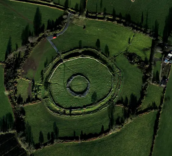
Circular area enclosed by two widely spaced banks with a smaller circular enclosure at the highest point of the hilltop (max enclosed area c. 300m N-S; 250 m E-W). Ramparts are visible as two distinct breaks in the slope (H 1-2m; distance apart 30-50m), followed by a field boundary at the SE. The central circular enclosure (diam. 45m) enclosed by bank indicated on OS 6-inch map.
Full archaeological record 714 words
Circular area enclosed by two widely spaced banks with a smaller circular enclosure at the highest point of the hilltop (max enclosed area c. 300m N-S; 250 m E-W). Ramparts are visible as two distinct breaks in the slope (H 1-2m; distance apart 30-50m), followed by a field boundary at the SE. The central circular enclosure (diam. 45m) enclosed by bank indicated on OS 6-inch map. The interior is masked by a dump of stones but may show low earthworks. A tumulus (KD038-025002-) is situated at the highest point of the hill within the central enclosure (Condit 1992, 16-20). Land reclamation was carried out in the field containing the hillfort in 1961 (OPW Field report 06/09/1961). Cropmark of multi-vallate hillfort visible on Cambridge University aerial photographs taken between 1966-68 (CUCAP APA039-042; AVL093-094; ASU052-053) (www.cambridgeairphotos.com/location/apa040/). Two parallel field banks forming a sunken way to the W of the hillfort which are visible on the aerial photographs (CUCAP APA040-042) may represent an ancient roadway.
In August 2015 excavation was carried out by Professor William O'Brien of UCC under licence number 15E0322. The excavation was undertaken as part of a research project on prehistoric hillforts in Ireland, based in University College Cork with funding from the Irish Research Council. The excavation at Hughstown consisted of a single trench across the defences of the second enclosure of this hillfort. Excavation confirmed the presence of a substantial ditch, with the remains of an accompanying bank on the inside. Samples of charcoal were recovered for radiocarbon dating (results pending). There are no artifact finds, apart from a single sherd of prehistoric pottery.
The entire site was investigated by magnetic gradiometry survey in 2012 under licence number 12R0130 (O’Driscoll 2013), along with LiDAR survey, this revealed a multiple enclosure hillfort (overall diam. 356m NW-SE by 261m NE-SW) consisting of four widely-spaced enclosing elements, the innermost being a sub-circular enclosure (diam. 54m NW-SE by 50m NE-SW) consisting of a low earthen bank with some large boulders, with no visible external ditch. This is surrounded by a large sub-oval enclosure (diam. 248, NW-SE by 197m NE-SW), which is visible in places as a low-relief ditch feature. The geophysical survey recorded this ditch as a line of high magnetic gradiometry readings, with lines of low readings on either side. The survey recorded a third enclosing element (diam. 290m NW-SE by 228m NE-SW), located 23–48m outside and concentric with the second enclosure. The outermost (fourth) enclosure (diam. 356m NW-SE by 261m NE-SW)has also been substantially levelled, and is also best imaged in the geophysical as a line of low gradiometry readings. Though mostly levelled, a portion is preserved as a curving field bank, along the north-east side of the outer enclosure (O'Brien 2015, 2).
The hillfort was recently described in the Atlas of Hillforts of Britain and Ireland as following; 'Cropmarks reveal a large, multiple enclosure surrounding the summit of Carrigeen Hill. Hughstwon hillfort is one of up to nine hillfort in a cluster surrounding the town of Baltinglass, Co. Wicklow. Roughly oval in plan, the hillfort has a total site footprint of 8.2ha. It is situated at the SW edge of the Wicklow Mountains in a commanding position, with panoramic views in all directions. Geophysical survey (O'Driscoll 2012) has revealed a complex system of enclosing elements. This includes an outer bank and ditch which surrounds a series of up to four closely set palisade features. The latter may have originally comprised two enclosures, each consisting of a bank (and possible palisade) with external ditch. The strong readings from the gradiometer survey imply that these features were destroyed by fire. Some possible hut structures were recorded by the geophysical survey. No entrance features were identified. At the summit of the hillfort is an extant enclosure. The bank of this enclosure comprises a circular band of large boulders approximately 55m in diameter. Near the centre of this enclosure, a circular bank of grass covered stones 18m in diameter may be the remains of a hut structure. Geophysical survey by O'Driscoll in 2012. LiDAR survey undertaken by Ordnance Survey Ireland. The Irish Army Air Corp and Cambridge aerial photographs reveal two enclosing elements as parch-marks, separated by 23 _ 48m.' (http://hillforts.arch.ox.ac.uk/records/IR0673.html)
Compiled and revised by: Gearóid Conroy and Caimin O'Brien
Date of revised upload: 6 February 2020
Archaeological Survey of Ireland, National Monuments Service (CC BY 4.0). It describes the site as it was when surveyed.
More hillforts nearby
Brusselstown Ring
Hillfort · Brusselstown,Castlequarter · Wicklow · 9.2 km away
 National Monument
Rathgall Hillfort
Hillfort · Rath East · Wicklow · 17 km away
Boley
Hillfort · Boley (Ballyadams By.) · Laois · 23 km away
Visitors' notes
Badges are opinions of visitors - not verified facts. One vote per badge and visitor; no account needed.
Best time to visit
What's missing on this page?
Share a tip to find it
Share a local tradition or story
Suggest a correction
Suggest the right map location
Report a duplicate page
Ask a question
Do not include personal data. See our privacy notice.
Around Hughstown
Other heritage nearby
- Baltinglass AbbeyAbbey or friary · 2.7 km
- Mary's WellHoly well · 5.4 km
- St Columbkille's WellHoly well · 6.3 km
- Moone AbbeyAncient church · 6.3 km
- Moone High CrossHigh cross · 6.4 km
- St. Patrick's WellHoly well · 6.7 km
Recorded within 5 km
- 18 ringfortsArchaeological Survey of Ireland
- 6 holy wellsArchaeological Survey of Ireland
- 5 hillfortsArchaeological Survey of Ireland
- 3 standing stonesArchaeological Survey of Ireland
- 3 castlesArchaeological Survey of Ireland
- 3 ancient churchesArchaeological Survey of Ireland
- 3 megalithic tombsArchaeological Survey of Ireland
- 1 monastic siteArchaeological Survey of Ireland
- 1 abbey or friaryArchaeological Survey of Ireland
Walks and trails
- Mullaghreelan Wood - O'Tuathaill walkWalking Trail · 2.0 km · nearest point 8.1 km
- Mullaghreelan Wood - Rath walkWalking Trail · 2.0 km · nearest point 8.1 km
- Fauna LoopWalking Trail · 6.3 km · nearest point 11 km
Outdoors, towns and places to stay
- Mullaghreelan WoodForests · 8.6 km
- TimolinWalled towns · 6.0 km
- CastledermotWalled towns · 6.9 km
- Martinstown HouseHistoric stays · 19 km
Other attractions nearby
- Tir na GlassWalking · 2.6 km
- Baltinglass AbbeyHistoric Houses and Castle · 2.7 km
- Tearmann Community GardenGardens · 3.3 km
- Moone High CrossHistoric Houses and Castle · 6.3 km
What's on nearby
- Derek Ryan - Songwriter Show2026-11-08 · 17 km
- Learn the Art of Letterpress2026-11-14 · 13 km
- Autumn / Winter Cinemas at VISUAL2026-12-22 · 17 km
Excavations nearby
- E2937 Ballyvass Site 1, County KildareRoad-scheme excavation report (TII) · 7.4 km
- E2936 Coolane Site 1, County KildareRoad-scheme excavation report (TII) · 7.7 km