
Unofficial guide. Not the National Monuments Service, the OPW, Fáilte Ireland or the landowner. Disclaimer
At a glance
- TypeHillfort
- Date or period mentionedNeolithic
- Recorded size 550m N-S; 320m E-W
- Condition (as surveyed)Ruined
What to look for
- Bank and ditch
- Entrance gap
- Hut sites
- Ramparts
Picked out from the Archaeological Survey description below.
Can you visit?
- No source says it is open to the public.Most monuments in Ireland stand on private farmland.
- Ask the landowner before crossing fields, close gates, leave the stones as you find them.Visiting responsibly
History and description
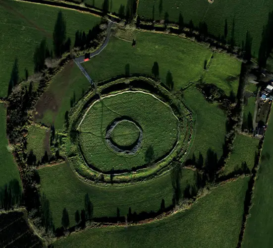
A very extensive hillfort complex occupying the whole of the Spinans Hill-Brusselstown hilltop, 6.4km NE of Baltinglass. The hillfort on Brusselstown Hill (known as 'Brusselstown Ring') (dims. c. 320m NW-SE; c. 200m NE-SW) is enclosed by a collapsed rampart (Wth 5-12m) composed of limestone boulders and is surmounted by a modern field wall.
Full archaeological record 663 words
A very extensive hillfort complex occupying the whole of the Spinans Hill-Brusselstown hilltop, 6.4km NE of Baltinglass. The hillfort on Brusselstown Hill (known as 'Brusselstown Ring') (dims. c. 320m NW-SE; c. 200m NE-SW) is enclosed by a collapsed rampart (Wth 5-12m) composed of limestone boulders and is surmounted by a modern field wall. The interior rises towards several high points (the highest is OD 1327) marked by limestone outcrops. A number of hut sites (WI027-018001-, WI027-018002-, WI027-019---- have been identified within Brusselstown Ring.The Spinans Hill hillfort (OD 1346) (dims. 550m N-S; 320m E-W), about 1.5km to the NW, comprises an irregularly shaped area enclosed by a peat-covered earthen bank, best preserved at N and E arid largely levelled over the remainder of its course. A large cairn and five smaller ones (WI027-017001) lie within the hillfort. At a lower level (OD c. 1000-1100), another outer rampart has been identified which encloses a roughly L-shaped area and encompasses both Spinans Hill and Brusselstown Hill (dims. c. 1500m NW-SE; c. 350-500m NE-SW; 130 hectares). The enclosing element consists in part of a double rampart with intervening fosse (av. total Wth 15m) faced with stone in some areas and is best preserved at E and W. Three gaps at N may represent original entranceways. Other features occurring within the complex are ancient field walls, a circular enclosure (diam. 17m) situated some 400m NW of Brusselstown Ring, and a circular platform of stones (diam. 10m) 50m SW of the enclosure. Outside the rampart to the N there is some evidence of settlement comprising enclosures, hut sites and field walls. (Price 1949, 162-5 and 1967, 508; Condit 1992, 16-20) (CUCAP, AHK048-049; AYP032-034)
The hillfort was recently described in the Atlas of Hillforts of Britain and Ireland as following; 'Multiple enclosure surrounding the SE flat-topped summit of Spinans Hill at SW edge of Wicklow mountains, with panoramic views. Brusselstown Ring is one of nine hillforts comprising the Baltinglass hillfort cluster. It has a total footprint of 32.43ha making it one of the largest hillforts in Ireland. The inner enclosing elements forms a complete circuit. The outer has been damaged at the SW but likely formed a complete circuit. The are four possible original entrances comprising simple breaks in the inner bank at the N, E, S and W. There are no apparent entrance features in the outer enclosing elements. Two structures have been recorded within the inner enclosure. Twenty three structures immediately outside the inner enclosing feature have also been identified (Grogan and Kilfeather 1997, 41). Internal enclosing elements survives almost intact. The outer has been damaged at SW and is covered by grass and heather for much of its circuit. Interior under grassland. Earliest identified map depiction in first edition Ordnance Survey 6 inch mapping. Monument survey by Condit (1992). Monument survey by Grogan and Kilfeather (1996, 25). Aerial photographs by the Cambridge aerial survey unit and GSI. Woodland abutting the outer enclosing elements at the N, NE and W and partially under woodland at NW. Interior heavily overgrown with scrub and bracken. The interior of Brusselstown Ring is characterized by large rock outcrops. The largest of these is located at the center of the monument and forms a substantial plateau overlooking the majority of the interior. S section of the enclosing elements form the boundary between Brusselstown and Castlequater townlands. Stone axe found on Spinans Hill indicating Neolithic activity on the hill, however, it is unknown if this was discovered within the hillfort (Condit 1992 20). There are two recorded hut structures within the interior of the hillfort (Grogan and Kilfeather 1997, 41). Twenty three hut structures have been recorded immediately outside of the inner enclosing elements at the S. A settlement cluster is recorded abutting the NW section of the outer enclosing elements. Four possible original entrance features at the N, E, S and W of the inner enclosing elements. These comprise simple breaks in the stone bank approximately 1 - 2 m in width.' (http://hillforts.arch.ox.ac.uk/records/IR0718.html)
References
- Date of revised upload: 7 February 2020
Archaeological Survey of Ireland, National Monuments Service (CC BY 4.0) · Compiled by Caimin O'Brien · Based on the Archaeological Inventory of County Wicklow. It describes the site as it was when surveyed.
More hillforts nearby
Hughstown
Hillfort · Hughstown · Kildare · 9.2 km away
 National Monument
Rathgall Hillfort
Hillfort · Rath East · Wicklow · 18 km away
Visitors' notes
Badges are opinions of visitors - not verified facts. One vote per badge and visitor; no account needed.
Best time to visit
What's missing on this page?
Share a tip to find it
Share a local tradition or story
Suggest a correction
Suggest the right map location
Report a duplicate page
Ask a question
Do not include personal data. See our privacy notice.
Around Brusselstown Ring
Other heritage nearby
- St. Bridget's WellHoly well · 1.3 km
- St. Bridget's WellHoly well · 2.2 km
- Castleruddery Stone CircleStone circle · 3.4 km
- TobermurryHoly well · 4.9 km
- Baltinglass AbbeyAbbey or friary · 6.6 km
- portal tomb of BroomfieldsMegalithic tomb · 7.3 km
Recorded within 5 km
- 23 ringfortsArchaeological Survey of Ireland
- 7 holy wellsArchaeological Survey of Ireland
- 6 castlesArchaeological Survey of Ireland
- 5 standing stonesArchaeological Survey of Ireland
- 4 hillfortsArchaeological Survey of Ireland
- 4 ancient churchesArchaeological Survey of Ireland
- 3 monastic sitesArchaeological Survey of Ireland
- 2 stone circlesArchaeological Survey of Ireland
- 2 megalithic tombsArchaeological Survey of Ireland
- 1 ogham stoneArchaeological Survey of Ireland
- 1 abbey or friaryArchaeological Survey of Ireland
Walks and trails
- Fauna Short LoopWalking Trail · 4.8 km · nearest point 4.0 km
- Fauna LoopWalking Trail · 6.3 km · nearest point 4.0 km
- Ballinfoyle - Mountain Access routeMountain Access Trail · 0.3 km · nearest point 5.7 km
Outdoors, towns and places to stay
- Glenealo Valley Nature ReserveNature reserves · 16 km
- TimolinWalled towns · 13 km
- Martinstown HouseHistoric stays · 21 km
Other attractions nearby
- Dwyer McAllister CottageHistoric Houses and Castle · 3.5 km
- Tearmann Community GardenGardens · 6.3 km
- Baltinglass AbbeyHistoric Houses and Castle · 6.6 km
- Tir na GlassWalking · 6.8 km
What's on nearby
- West Wicklow Festival 20262026-11-13 · 18 km
- Learn the Art of Letterpress2026-11-14 · 17 km
- West Wicklow Festival 20262026-11-14 · 18 km