
Unofficial guide. Not the National Monuments Service, the OPW, Fáilte Ireland or the landowner. Disclaimer
At a glance
- TypeHillfort
What to look for
- Bank and ditch
- Entrance gap
- Ramparts
Picked out from the Archaeological Survey description below.
Can you visit?
- No source says it is open to the public.Most monuments in Ireland stand on private farmland.
- Ask the landowner before crossing fields, close gates, leave the stones as you find them.Visiting responsibly
History and description
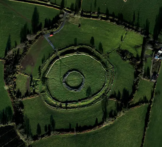
Prominently located at the end of a N-S ridge. A circular area (diam. c. 112m) defined by a massive bank (Wth c. 10.6m; int. H c. 3.5m; ext. H c. 1m) and external fosse except at NE. Possible entrance at ESE.
Full archaeological record 197 words
Prominently located at the end of a N-S ridge. A circular area (diam. c. 112m) defined by a massive bank (Wth c. 10.6m; int. H c. 3.5m; ext. H c. 1m) and external fosse except at NE. Possible entrance at ESE. Well in fosse at E.
The hillfort was recently described in the Atlas of Hillforts of Britain and Ireland as following; 'Large multiple enclosure surrounding the domed summit of Boley Hill, on the NE edge of the Castlecomer Hills. Widely spaced enclosing elements with a total site footprint of approximately 28.1ha. There is a simple break in the SW of the inner enclosing elements. Natural spring located in the ditch of the inner enclosing elements at the E. No evidence for any internal features on the surface. Inner rampart survives well throughout its circuit. The possible outer enclosing element survives as a curving field boundary in the W. This is concentric with the inner enclosing element. The remainder is likely to have been destroyed. Interior is under pasture. Tree cover within the interior of the inner enclosing elements. First map identification in first edition Ordnance Survey mapping. Monument survey by Sweetman et al. (1995, 16).' (http://hillforts.arch.ox.ac.uk/records/IR0738.html).
References
- Date of revised upload: 6 February 2020
Archaeological Survey of Ireland, National Monuments Service (CC BY 4.0) · Compiled by David Sweetman · Based on the Archaeological Inventory of County Laois. It describes the site as it was when surveyed.
More hillforts nearby
Visitors' notes
Badges are opinions of visitors - not verified facts. One vote per badge and visitor; no account needed.
Best time to visit
What's missing on this page?
Share a tip to find it
Share a local tradition or story
Suggest a correction
Suggest the right map location
Report a duplicate page
Ask a question
Do not include personal data. See our privacy notice.
Around Boley
Other heritage nearby
- St Patrick's WellHoly well · 2.1 km
- Kilmackeady ChurchAncient church · 4.4 km
- Ballyadams CastleCastle · 4.8 km
- St Abban's WellHoly well · 5.6 km
- St Brigid's WellHoly well · 6.7 km
- Fossy ChurchAncient church · 7.9 km
Recorded within 5 km
- 7 castlesArchaeological Survey of Ireland
- 6 holy wellsArchaeological Survey of Ireland
- 6 ringfortsArchaeological Survey of Ireland
- 6 ancient churchesArchaeological Survey of Ireland
- 2 megalithic tombsArchaeological Survey of Ireland
- 1 monastic siteArchaeological Survey of Ireland
- 1 abbey or friaryArchaeological Survey of Ireland
Walks and trails
- Oughaval Woods - Cobbler's Castle WalkWalking Trail · 6.0 km · nearest point 7.9 km
- Oughaval Woods - Mass Rock WalkWalking Trail · 2.9 km · nearest point 8.2 km
- Oughaval Woods - Beech Way WalkWalking Trail · 2.1 km · nearest point 9.1 km
Outdoors, towns and places to stay
- OughavalForests · 9.3 km
- Mullaghreelan WoodForests · 14 km
- Timahoe Esker Nature ReserveNature reserves · 9.5 km
- AthyWalled towns · 10 km
- CarlowWalled towns · 14 km
Other attractions nearby
- Timahoe Round TowerHistoric Houses and Castle · 8.8 km
- Athy Boat Tours by BoatTrips.ieNature and Wildlife · 10 km
- Guided Tours of Athy Town by Athy Walking ToursWalking · 10 km
- Killeshin Romanesque DoorwayHistoric Houses and Castle · 10 km
What's on nearby
- Derek Ryan - Songwriter Show2026-11-08 · 14 km
- Pa Sheehy – The Magic We Found Tour2026-11-13 · 19 km
- Dirty DC – AC/DC Tribute2026-11-20 · 19 km