

Unofficial guide. Not the National Monuments Service, the OPW, Fáilte Ireland or the landowner. Disclaimer
At a glance
- TypeStone circle - embanked
- StatusNational Monument
What to look for
- Stones still standing
Picked out from the Archaeological Survey description below.
Can you visit?
- No source says it is open to the public.Most monuments in Ireland stand on private farmland.
- Ask the landowner before crossing fields, close gates, leave the stones as you find them.Visiting responsibly
History and description
National Monument in state ownership No. 441. Situated on a natural rise with gentle slopes to S, W and E and overlooking the River Slaney (250m to the S).
Full archaeological record 250 words
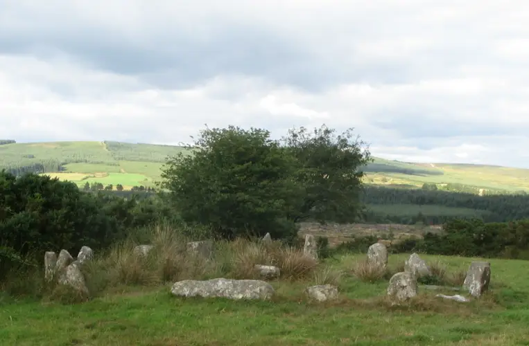
National Monument in state ownership No. 441. Situated on a natural rise with gentle slopes to S, W and E and overlooking the River Slaney (250m to the S). The stone circle (diam. 30m) consists of large boulders, originally contiguous, some standing upright and others erected on their long axis. The circle is largely intact at the N but is less well-preserved to the S. It consists of twenty-nine substantial stones and a number of smaller fragments with some loose boulders occurring in the interior which is otherwise featureless. Wedge marks and boreholes in several stones indicate deliberate destruction. The entrance (Wth 1.3m) appears to be between two exceptionally large quartz boulders (L 2.4m and 3m; Wth 1.2m and 1.8m) at the E. Abutting onto the outer face of the circle is an earthen bank (diam. 40m; Wth 4.5m; max. H 1m), the terminals of which encompass the quartz boulders of the entrance. Some boulders along the outer edge of the bank may indicate an outer revetment. To the E of the entrance (at 15.8m) is a single upright stone. A field bank cuts across the outer edge of the bank at the S. The site occurs centrally within a well-defined cropmark enclosure (diam. c. 80m; CUCAP, BDR039) defined by a fosse (Wth c. 4-5m). Between this and the earthen bank is a narrower cropmark defined by a trench or narrow fosse (diam. c. 50m; Wth c. 1m). (Walshe 1931, 131-4; Leask 1945, 266-7; Burl 1993, 106, 240; 1995, 249-50)
References
- This monument is subject to a preservation order made under the National Monuments Acts 1930 to 2014 (PO no. 109/1940).
Archaeological Survey of Ireland, National Monuments Service (CC BY 4.0) · Updated 30 June 2010 G. Conroy · Based on the Archaeological Inventory of County Wicklow. It describes the site as it was when surveyed.
More stone circles nearby


Visitors' notes
Badges are opinions of visitors - not verified facts. One vote per badge and visitor; no account needed.
Best time to visit
What's missing on this page?
Share a tip to find it
Share a local tradition or story
Suggest a correction
Suggest the right map location
Report a duplicate page
Ask a question
Do not include personal data. See our privacy notice.
Around Castleruddery Stone Circle
Other heritage nearby
- TobermurryHoly well · 2.0 km
- Brusselstown RingHillfort · 3.4 km
- portal tomb of BroomfieldsMegalithic tomb · 4.2 km
- St. Bridget's WellHoly well · 4.3 km
- St. Bridget's WellHoly well · 5.1 km
- Tornant UpperMegalithic tomb · 7.0 km
Recorded within 5 km
- 27 ringfortsArchaeological Survey of Ireland
- 6 castlesArchaeological Survey of Ireland
- 5 standing stonesArchaeological Survey of Ireland
- 4 holy wellsArchaeological Survey of Ireland
- 3 ancient churchesArchaeological Survey of Ireland
- 3 hillfortsArchaeological Survey of Ireland
- 1 ogham stoneArchaeological Survey of Ireland
- 1 abbey or friaryArchaeological Survey of Ireland
- 1 megalithic tombArchaeological Survey of Ireland
- 1 monastic siteArchaeological Survey of Ireland
Walks and trails
- Fauna LoopWalking Trail · 6.3 km · nearest point 1.7 km
- Fauna Short LoopWalking Trail · 4.8 km · nearest point 1.9 km
- Kilcoagh LoopWalking Trail · 10.8 km · nearest point 3.7 km
Outdoors, towns and places to stay
- Glenealo Valley Nature ReserveNature reserves · 17 km
- TimolinWalled towns · 12 km
- CalverstownWalled towns · 15 km
- Martinstown HouseHistoric stays · 18 km
Other attractions nearby
- Dwyer McAllister CottageHistoric Houses and Castle · 5.8 km
- Baltinglass AbbeyHistoric Houses and Castle · 7.2 km
- Tearmann Community GardenGardens · 7.3 km
- Tir na GlassWalking · 7.5 km
What's on nearby
- West Wicklow Festival 20262026-11-13 · 16 km
- Learn the Art of Letterpress2026-11-14 · 14 km
- West Wicklow Festival 20262026-11-14 · 16 km