


Unofficial guide. Not the National Monuments Service, the OPW, Fáilte Ireland or the landowner. Disclaimer
At a glance
- TypeCross - High cross
- Recorded sizeH 2.15m; W 1.09m; shaft W 0.45m; T 0.35m
What to look for
- Carved scenes
- Ring
- Base
Picked out from the Archaeological Survey description below.
Can you visit?
- No source says it is open to the public.Most monuments in Ireland stand on private farmland.
- Ask the landowner before crossing fields, close gates, leave the stones as you find them.Visiting responsibly
History and description
On a flat-topped hill, surrounded by pasture. The cross is within a small enclosure with a metal fence which rests on a stone platform which surrounds the stone.
Full archaeological record 548 words
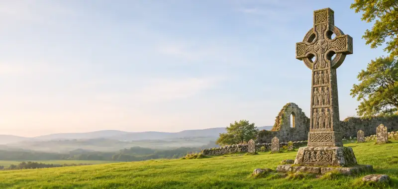
On a flat-topped hill, surrounded by pasture. The cross is within a small enclosure with a metal fence which rests on a stone platform which surrounds the stone. According to Carrigan (1905, vol. 4, 45), the name Kilree is derived from Cill Ruidhche, after St Ruidhche, a female saint who is commemorated on the 8th of February. A pre-Romanesque church (KK027-004401-) and round tower (KK027-044003-) are located 50m to the E and NE respectively. A sandstone ringed-cross (H 2.15m; Wth 1.09m; shaft Wth 0.45m; T 0.35m) with a tenon at the top but no cap stone, which stands on a stepped base (dims. 1.15m x 1.08m; H 0.5m). The centre of the E and W faces of the cross head are similarly decorated with a large domed boss surrounded by a ring of broad interlace contained by a roll moulding. Beneath the roundel on the W face, there is a horizontal panel which has been interpreted as the adoration of the Magi (Harbison, 1992, vol. 2, 134) and as Daniel in the lion’s den (Richardson and Scarry 1990, 43). There is a raised boss at the top of the shaft beneath this figurative panel. Each arm of the W face is decorated with a boss surrounded by a spiral coil, the top arm having an additional spiral above. The arms on the E face are decorated with a hunting scene and procession of horses (ibid.). The S-facing terminal of the S arm is divided into four figurative panels with a circle at the centre. The upper scenes are uncertain though for the top left Harbison (1992, vol. 2, 133) suggests Salome dancing and he suggests a lion for the top right; the bottom left is variously interpreted as St John the Baptist embracing Christ (ibid.) and as Jacob and the angel (Richardson and Scarry 1990, 43) while the bottom right is interpreted as the beheading of John the Baptist (Harbison 1992, vol. 2, 134) and as David and the lion (Richardson and Scarry 1990, 43). The segments of the ring have roll mouldings enclosing panels of interlace. The decoration on the shaft is described by Harbison (1992, vol. 2, 134-5). The lower E face of the shaft is decorated with a fluid fretwork pattern and the upper with a dense fret-spiral. The W face, though worn, consisted of two separate sections, the upper one forming circles of different sizes. At the centre of the top of the upper panel there is a small domed boss. The S side is divided into three panels by vertical ribs, the left is too worn to identify but the middle panel contains fretwork and that on the right interlace. The N side is similarly divided in three, the side panels being decorated with fretwork and spiral scrolls and the middle panel with interlace. The base of the cross is also decorated but is very worn. On the lower step Harbison (ibid.) identified stepped decoration on the E face, meander decoration on the S side and possible angular decoration on the W face, while on the upper step he identified a panel of negative and positive squares arranged to form sunken squares and T-shapes on the N side and suggests there may have been figures on the S face.
(National Monument no. 76)
Archaeological Survey of Ireland, National Monuments Service (CC BY 4.0) · Compiled by Jean Farrelly · Updated 6 February 2017. It describes the site as it was when surveyed.
Folklore and traditions
More high crosses nearby
 National Monument
Killamery High Cross
Cross - High cross · Killamery · Kilkenny · 13 km away
 National Monument
Ahenny High Crosses
Cross - High cross · Ahenny · Tipperary · 14 km away
 National Monument
Kilkieran High Crosses
Cross - High cross · Castletown (Iverk By) · Kilkenny · 15 km away
Leggetsrath East High Cross
Cross - High cross · Leggetsrath East · Kilkenny · 15 km away
 National Monument
Ullard high cross
Cross - High cross · Ullard · Kilkenny · 24 km away
 National Monument
Lorum High Cross
Cross - High cross · Lorum · Carlow · 28 km away
Also recorded nearby
Named sites within 5 km with only a short entry in the Archaeological Survey.
- Dunnamaggan ChurchChurch · Dunnamaggan East · 2.5 km · official record
- St Leonard's WellRitual site - holy well · Dunnamaggan East · 2.6 km · official record
- Clone CastleCastle - unclassified · Clone (Kells By.) · 5.0 km · official record
Visitors' notes
Badges are opinions of visitors - not verified facts. One vote per badge and visitor; no account needed.
Best time to visit
What's missing on this page?
Share a tip to find it
Share a local tradition or story
Suggest a correction
Suggest the right map location
Report a duplicate page
Ask a question
Do not include personal data. See our privacy notice.
Around Kilree High Cross
Other heritage nearby
- Kilree Round TowerRound tower · 0.1 km
- Kilree monastic siteAncient church · 0.1 km
- ToberbrideHoly well · 0.4 km
- St. Kieran's ChurchAncient church · 2.1 km
- Saint Kieran's WellHoly well · 2.3 km
- Kells PrioryAbbey or friary · 2.3 km
Recorded within 5 km
- 14 ringfortsArchaeological Survey of Ireland
- 12 castlesArchaeological Survey of Ireland
- 9 ancient churchesArchaeological Survey of Ireland
- 7 holy wellsArchaeological Survey of Ireland
- 1 round towerArchaeological Survey of Ireland
- 1 monastic siteArchaeological Survey of Ireland
- 1 abbey or friaryArchaeological Survey of Ireland
Walks and trails
- South Kilkenny Cycle LoopRoad Cycling Trail · 43.2 km · nearest point 2.0 km
- Castlemorris - Fern LoopWalking Trail · 2.4 km · nearest point 5.4 km
- Castlemorris - Holly LoopWalking Trail · 4.8 km · nearest point 5.4 km
Outdoors, towns and places to stay
- CastlemorrisForests · 7.7 km
- Coill an FhaltaighForests · 12 km
- Garryricken Nature ReserveNature reserves · 10 km
- Kyleadohir Nature ReserveNature reserves · 13 km
- CallanWalled towns · 8.7 km
- ThomastownWalled towns · 8.9 km
Other attractions nearby
- Kells PrioryHistoric Houses and Castle · 2.3 km
- Gáirdín an GhortaGardens · 4.9 km
- Mount Juliet Equestrian CentreNature and Wildlife · 5.2 km
- Jerpoint AbbeyHistoric Houses and Castle · 7.6 km
What's on nearby
- Pa Sheehy The Magic We Found Tour2026-11-05 · 15 km
- Kilkenomics2026-11-06 · 15 km
- Kilkenomics2026-11-07 · 15 km