
Unofficial guide. Not the National Monuments Service, the OPW, Fáilte Ireland or the landowner. Disclaimer
At a glance
- TypeStone circle
- StatusNational Monument
What to look for
- Stones still standing
Picked out from the Archaeological Survey description below.
Can you visit?
- No source says it is open to the public.Most monuments in Ireland stand on private farmland.
- Ask the landowner before crossing fields, close gates, leave the stones as you find them.Visiting responsibly
History and description
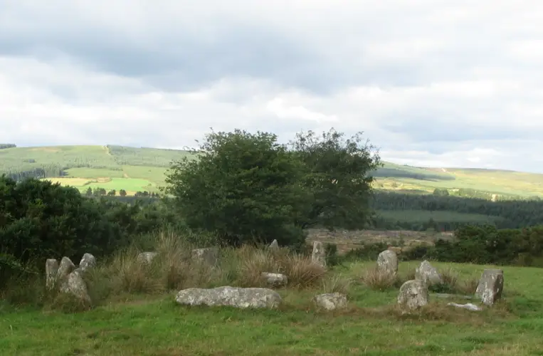
In pasture, located on a ridge, just below and to E of the highest point, close to the break of slope where ground falls away to S, giving excellent views over the Palmerstown River estuary and Kilalla Bay. Nephin and the Nephin Beg mountain range define the far horizon to S-SW. There is a mound (MA015-025002-) 50m to SW.
Full archaeological record 357 words
In pasture, located on a ridge, just below and to E of the highest point, close to the break of slope where ground falls away to S, giving excellent views over the Palmerstown River estuary and Kilalla Bay. Nephin and the Nephin Beg mountain range define the far horizon to S-SW. There is a mound (MA015-025002-) 50m to SW.
This stone circle is a National Monument in State ownership (No. 389). It is indicated as ‘Cromlech’ on the 1838 OS 6-inch map where it is depicted as simple circle. It, and the adjacent mound (MA015-026002-), are indicated as ‘Cromlechs’ and are both depicted as rough circles of boulders on the 25-inch plan; on the 1922 6-inch edition the stone circle is marked with a dolmen-type symbol.
De Valera & Ó Nualláin (1964, 94) record this stone circle as follows: ‘Marked ‘cromlech’ on the O.S.6” 1837. This is the more northerly of the two monuments marked under the name ‘Cromlechs’ in Rathfran in the current edition [1922] of the map. It is a stone circle consisting of some sixteen stones five of which are now prostrate. Those remaining erect are from 0.5 m. to 1.60 m. high. The stones vary from 0.85 m to 2.00 m. in length and from .40 m. to 1.2m. in thickness. The area enclosed measures 17.00 m. (N-S) by 19.00 m. (E-W).’
An inspection in 1994 recorded the stone circle as a circular area (19.5m E-W; 19m N-S) defined by a broad, low bank (Wth 4-5m; int. H 0.2m; ext. H 0.4m at N, 1.1m at S) in which are set twelve upright boulders. The boulders are rounded or irregular in form, and vary in size (Circ. c. 2.5-4m) and height (0.8-1.45m). They are set at irregular intervals around the circumference of the bank, some set against the inner face, but others set in the bank. Two large prostrate stones and a number of smaller stones protrude randomly from the bank, some or all of which may be the result of field clearance. The bank is generally rather low and degraded; there are two corresponding gaps (Wth 2-2.5m) at the E and W.
Archaeological Survey of Ireland, National Monuments Service (CC BY 4.0) · Compiled by Jane O'Shaughnessy · Updated 28 November 2017. It describes the site as it was when surveyed.
Visitors' notes
Badges are opinions of visitors - not verified facts. One vote per badge and visitor; no account needed.
Best time to visit
What's missing on this page?
Share a tip to find it
Share a local tradition or story
Suggest a correction
Suggest the right map location
Report a duplicate page
Ask a question
Do not include personal data. See our privacy notice.
Around Rathfran Stone Circle
Other heritage nearby
- Rathfran RingfortRingfort · 0.7 km
- Rathfran PrioryAbbey or friary · 0.7 km
- Rathfranpark Wedge TombMegalithic tomb · 0.8 km
- Breastagh Ogham StoneOgham stone · 0.9 km
- Killala Round TowerRound tower · 3.6 km
- Kilcummin ChurchAncient church · 4.2 km
Recorded within 5 km
- 90 ringfortsArchaeological Survey of Ireland
- 13 megalithic tombsArchaeological Survey of Ireland
- 8 castlesArchaeological Survey of Ireland
- 6 holy wellsArchaeological Survey of Ireland
- 5 ancient churchesArchaeological Survey of Ireland
- 4 standing stonesArchaeological Survey of Ireland
- 1 abbey or friaryArchaeological Survey of Ireland
- 1 stone circleArchaeological Survey of Ireland
- 1 ogham stoneArchaeological Survey of Ireland
- 1 monastic siteArchaeological Survey of Ireland
- 1 round towerArchaeological Survey of Ireland
Walks and trails
- Kilcummin Loop Walks - Red LoopWalking Trail · 10.3 km · nearest point 2.1 km
- Kilcummin Loop Walks - Blue LoopWalking Trail · 8.7 km · nearest point 2.3 km
- Kilcummin Loop Walks - Green LoopWalking Trail · 4.7 km · nearest point 2.3 km
Outdoors, towns and places to stay
- BlanemoreForests · 12 km
- BelleekForests · 14 km
- Ross Beach, KillalaBeaches · 3.0 km · Excellent Quality (2025)
- Enniscrone BeachBeaches · 9.5 km · Excellent Quality (2025)
- Enniscoe HouseHistoric stays · 20 km
Other attractions nearby
- Rathfran AbbeyHistoric Houses and Castle · 0.7 km
- Ross Beach, KillalaBeach · 3.0 km
- Killala QuayAttraction · 3.6 km
- Moyne AbbeyHistoric Houses and Castle · 6.2 km
What's on nearby
- Travelling Banner Exhibition | Photo Detectives2026-12-16 · 20 km · free