
Unofficial guide. Not the National Monuments Service, the OPW, Fáilte Ireland or the landowner. Disclaimer
At a glance
- TypeOgham stone
- Recorded sizecurrent H 2.75m; 0.98m WSW-ENE; 0.58m NNW-SSE
- StatusNational Monument
What to look for
- Ogham inscription
- Cross carved
Picked out from the Archaeological Survey description below.
Can you visit?
- No source says it is open to the public.Most monuments in Ireland stand on private farmland.
- Ask the landowner before crossing fields, close gates, leave the stones as you find them.Visiting responsibly
History and description
Located in coastal pasture. There is a wedge tomb (MA015-017) c. 300m to N.
Full archaeological record 233 words
Located in coastal pasture. There is a wedge tomb (MA015-017) c. 300m to N.
This ogham stone is a national monument (no. 415) in state guardianship. When discovery in the 1874, the ogham stone (total L c. 3.6m) lay prostrate on the ground. It appeared to overlie a possible grave (MA015-018002-), a cavity at the S end of which was identified as the socket in which the stone once stood (Ferguson, 1870-9, 201-206). The stone was soon afterwards erected in its current position.
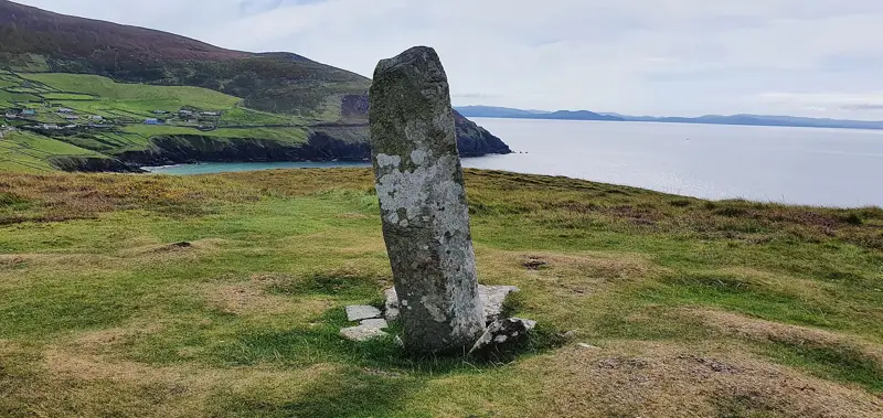
It consists of a massive upright stone (current H 2.75m; 0.98m WSW-ENE; 0.58m NNW-SSE), with a rectangular cross-section. The top of the stone is cut obliquely, so that it rises to a point at one side. There are ogham inscriptions on the NE and SE angles. The inscription extends the entire length of the NE angle; it is partly obscured by lichen. On the SE angle, the inscription begins 1.2m above ground level. Sections of the inscription on both angles have been eroded. The inscriptions have been interpreted as:
(left angle) L[ ... ]G̣G̣[ ... ]SD[ ... ]LENGẸṢCẠ[D]
(right angle) MAQ CORRBRI MAQ AMMLLỌNG[I]TT -which may be translated as '... son of Coirpre son of Amalgaid.'
This stone has been studied as part of the ‘Ogham in 3D’ project undertaken by the School of Celtic Studies, Dublin Institute for Advanced Studies. To access details go to the following website: http://ogham.celt.dias.ie/search.php?ciic=10
References
- This monument is subject to a preservation order made under the National Monuments Acts 1930 to 2014 (PO no. 89/1940).
Archaeological Survey of Ireland, National Monuments Service (CC BY 4.0) · Compiled by Jane O’Shaughnessy · Updated 15 November 2018. It describes the site as it was when surveyed.
Visitors' notes
Badges are opinions of visitors - not verified facts. One vote per badge and visitor; no account needed.
Best time to visit
What's missing on this page?
Share a tip to find it
Share a local tradition or story
Suggest a correction
Suggest the right map location
Report a duplicate page
Ask a question
Do not include personal data. See our privacy notice.
Around Breastagh Ogham Stone
Other heritage nearby
- Rathfranpark Wedge TombMegalithic tomb · 0.5 km
- Rathfran Stone CircleStone circle · 0.9 km
- Rathfran PrioryAbbey or friary · 1.1 km
- Rathfran RingfortRingfort · 1.6 km
- Killala Round TowerRound tower · 4.3 km
- Kilcummin ChurchAncient church · 4.4 km
Recorded within 5 km
- 94 ringfortsArchaeological Survey of Ireland
- 17 megalithic tombsArchaeological Survey of Ireland
- 7 castlesArchaeological Survey of Ireland
- 6 holy wellsArchaeological Survey of Ireland
- 6 ancient churchesArchaeological Survey of Ireland
- 3 standing stonesArchaeological Survey of Ireland
- 2 stone circlesArchaeological Survey of Ireland
- 1 abbey or friaryArchaeological Survey of Ireland
- 1 monastic siteArchaeological Survey of Ireland
- 1 round towerArchaeological Survey of Ireland
Walks and trails
- Kilcummin Loop Walks - Red LoopWalking Trail · 10.3 km · nearest point 2.1 km
- Kilcummin Loop Walks - Blue LoopWalking Trail · 8.7 km · nearest point 2.6 km
- Kilcummin Loop Walks - Green LoopWalking Trail · 4.7 km · nearest point 2.6 km
Outdoors, towns and places to stay
- BlanemoreForests · 12 km
- Ross Beach, KillalaBeaches · 4.0 km · Excellent Quality (2025)
- Enniscrone BeachBeaches · 10 km · Excellent Quality (2025)
- Enniscoe HouseHistoric stays · 20 km
Other attractions nearby
- Rathfran AbbeyHistoric Houses and Castle · 1.1 km
- Ross Beach, KillalaBeach · 3.9 km
- Killala QuayAttraction · 4.3 km
- Moyne AbbeyHistoric Houses and Castle · 7.0 km
What's on nearby
- Travelling Banner Exhibition | Photo Detectives2026-12-16 · 20 km · free