
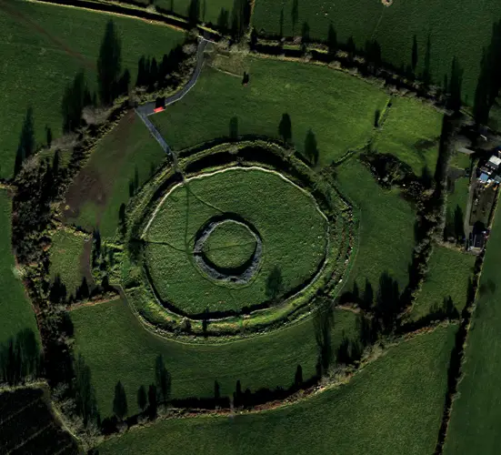
Unofficial guide. Not the National Monuments Service, the OPW, Fáilte Ireland or the landowner. Disclaimer
At a glance
- TypeHillfort
- StatusNational Monument
What to look for
- Bank and ditch
- Entrance gap
Picked out from the Archaeological Survey description below.
Can you visit?
- No source says it is open to the public.Most monuments in Ireland stand on private farmland.
- Ask the landowner before crossing fields, close gates, leave the stones as you find them.Visiting responsibly
History and description
Occupying the SW end of a NE-SW ridge (L c. 1.2km) that has three summits, the ground falls away steeply on all sides except N-NE where the slope is much less before the ground rises again to the central summit. This almost perfectly circular hilltop enclosure is represented as field banks with no annotation on the 1836 and 1908 editions of the OS 6-inch map, although the hilltop barrow is described as a ‘Moat’.
Full archaeological record 186 words
Occupying the SW end of a NE-SW ridge (L c. 1.2km) that has three summits, the ground falls away steeply on all sides except N-NE where the slope is much less before the ground rises again to the central summit. This almost perfectly circular hilltop enclosure is represented as field banks with no annotation on the 1836 and 1908 editions of the OS 6-inch map, although the hilltop barrow is described as a ‘Moat’. The enclosure is a circular grass-covered area (diam. 164.5m E-W; 163m N-S) defined by an earthen bank that had been adapted as a field bank with a stone-facing and outer drain, especially N-SE. In an untouched form the bank can vary (Wth of base 4-5m; int. H 0.2-.5m; ext. H c. 2-2.5m) and the outer fosse can vary from very slight (Wth c. 3m; ext. D 0.5m) to more substantial and rock-cut (ext. D c. 1.5m). An original entrance is not identified. (Ó Riordáin (1956)
This monument is subject to a preservation order made under the National Monuments Acts 1930 to 2014 (PO no. 12/1987), and is in state ownership: No. 651.
References
- Amended: 3 August 2022
Archaeological Survey of Ireland, National Monuments Service (CC BY 4.0) · Compiled by Michael Moore · Updated 10 July 2007 · Based on the Archaeological Inventory of County Meath. It describes the site as it was when surveyed.
More hillforts nearby
Kilriffin
Hillfort · Kilriffin,Sallybrook · Meath · 12 km away
 National Monument
Hill of Tara
Hillfort · Castleboy (Skreen By., Tara Par.) · Meath · 21 km away
Visitors' notes
Badges are opinions of visitors - not verified facts. One vote per badge and visitor; no account needed.
Best time to visit
What's missing on this page?
Share a tip to find it
Share a local tradition or story
Suggest a correction
Suggest the right map location
Report a duplicate page
Ask a question
Do not include personal data. See our privacy notice.
Around Mountfortescue Hillfort
Other heritage nearby
- Saint Patrick's WellHoly well · 5.4 km
- St. Patrick's Church, Hill of SlaneAncient church · 5.4 km
- Slane CastleCastle · 5.8 km
- Lady WellHoly well · 5.9 km
- Smarmore CastleCastle · 6.0 km
- Mellifont AbbeyAbbey or friary · 7.6 km
Recorded within 5 km
- 18 ringfortsArchaeological Survey of Ireland
- 4 standing stonesArchaeological Survey of Ireland
- 4 ancient churchesArchaeological Survey of Ireland
- 2 castlesArchaeological Survey of Ireland
- 1 holy wellArchaeological Survey of Ireland
- 1 megalithic tombArchaeological Survey of Ireland
Walks and trails
- Littlewood - Forest WalkWalking Trail · 2.1 km · nearest point 5.0 km
- Boyne Valley CaminoWalking Trail · 20.5 km · nearest point 10 km
- Townley Hall - Balnumber Wood WalkWalking Trail · 1.2 km · nearest point 10 km
Outdoors, towns and places to stay
- LittlewoodForests · 5.6 km
- Townley HallForests · 11 km
- SiddanWalled towns · 6.7 km
- ArdeeWalled towns · 11 km
- Brú na Bóinne UNESCO World Heritage SiteUNESCO · 10 km
- Collon HouseHistoric stays · 6.3 km
Other attractions nearby
- Hill of SlaneHistoric Houses and Castle · 5.4 km
- Killary Monastic SiteAbbeys and Monastery · 6.3 km
- Collon HouseHistoric Houses and Castle · 6.3 km
- Francis Ledwidge MuseumHistoric Houses and Castle · 6.9 km
What's on nearby
- Samhain Festival of Food & Culture2026-11-05 · 20 km
- Raw & Natural: Exploring Irish Raw Milk Cheeses and Natural Wines2026-11-06 · 18 km
- Samhain Festival of Food & Culture2026-11-06 · 20 km