
Unofficial guide. Not the National Monuments Service, the OPW, Fáilte Ireland or the landowner. Disclaimer
At a glance
- TypeHillfort
What to look for
- Bank and ditch
Picked out from the Archaeological Survey description below.
Can you visit?
- No source says it is open to the public.Most monuments in Ireland stand on private farmland.
- Ask the landowner before crossing fields, close gates, leave the stones as you find them.Visiting responsibly
History and description
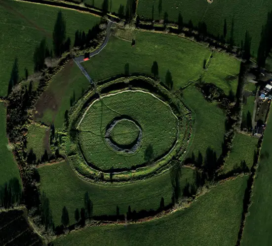
Aerial photograph (GB92.FD.37) shows cropmark of circular enclosure (diam. c. 100-110m) defined by the remains of a bank and an external ditch feature. A small circular enclosure is located at the centre of the enclosure, possibly a ring-ditch or house site.
Full archaeological record 89 words
Aerial photograph (GB92.FD.37) shows cropmark of circular enclosure (diam. c. 100-110m) defined by the remains of a bank and an external ditch feature. A small circular enclosure is located at the centre of the enclosure, possibly a ring-ditch or house site. Located on the summit of Drumran Hill. It is mainly plough-levelled, but low-level earthworks may survive in the north-western segment of the enclosure and in the western segment. The enclosure is bisected by two modern field boundaries. It can also be seen on the OSI aerial images (2005).
Archaeological Survey of Ireland, National Monuments Service (CC BY 4.0) · Compiled by Geraldine Stout · Updated 23 February 2010. It describes the site as it was when surveyed.
More hillforts nearby
Also recorded nearby
Named sites within 5 km with only a short entry in the Archaeological Survey.
- Lady's WellRitual site - holy well · Woodtown Upper · 4.3 km · official record
Visitors' notes
Badges are opinions of visitors - not verified facts. One vote per badge and visitor; no account needed.
Best time to visit
What's missing on this page?
Share a tip to find it
Share a local tradition or story
Suggest a correction
Suggest the right map location
Report a duplicate page
Ask a question
Do not include personal data. See our privacy notice.
Around Kilriffin
Other heritage nearby
- Smarmore CastleCastle · 8.3 km
- Hatch's CastleCastle · 9.0 km
- Ardee CastleCastle · 9.0 km
- Cruicetown ChurchAncient church · 9.3 km
Recorded within 5 km
- 41 ringfortsArchaeological Survey of Ireland
- 9 castlesArchaeological Survey of Ireland
- 4 ancient churchesArchaeological Survey of Ireland
- 3 standing stonesArchaeological Survey of Ireland
- 1 high crossArchaeological Survey of Ireland
- 1 monastic siteArchaeological Survey of Ireland
- 1 holy wellArchaeological Survey of Ireland
Walks and trails
- Dun a Ri - Yellow Walk - Access for AllWalking Trail · 0.6 km · nearest point 11 km
- Dun a Ri - Village WalkWalking Trail · 1.8 km · nearest point 11 km
- Dun a Ri - River WalkWalking Trail · 2.9 km · nearest point 11 km
Outdoors, towns and places to stay
- Dun an Ri Forest ParkForests · 11 km
- Dun a Ri Forest ParkForests · 11 km
- Greaghlone LakeBeaches · 18 km
- Creevy LakeBeaches · 18 km
- SiddanWalled towns · 5.3 km
- ArdeeWalled towns · 9.1 km
- Brú na Bóinne UNESCO World Heritage SiteUNESCO · 22 km
- Collon HouseHistoric stays · 15 km
Other attractions nearby
- Long Acre AlpacasNature and Wildlife · 6.6 km
- Kildemock Jumping ChurchHistoric Houses and Castle · 11 km
What's on nearby
- Samhain Festival of Food & Culture2026-11-05 · 19 km
- Raw & Natural: Exploring Irish Raw Milk Cheeses and Natural Wines2026-11-06 · 17 km
- Samhain Festival of Food & Culture2026-11-06 · 19 km