


Unofficial guide. Not the National Monuments Service, the OPW, Fáilte Ireland or the landowner. Disclaimer
At a glance
- TypeHillfort
- StatusNational Monument
Picked out from the Archaeological Survey description below.
Can you visit?
- No source says it is open to the public.Most monuments in Ireland stand on private farmland.
- Ask the landowner before crossing fields, close gates, leave the stones as you find them.Visiting responsibly
History and description
The following description is derived from the published 'Archaeological Inventory of County Meath' (Dublin: Stationery Office, 1987). In certain instances the entries have been revised and updated in the light of recent research.
Full archaeological record 33 words
The following description is derived from the published 'Archaeological Inventory of County Meath' (Dublin: Stationery Office, 1987). In certain instances the entries have been revised and updated in the light of recent research.
References
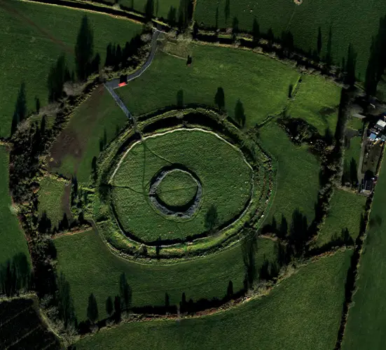
- Roughly oval area, defined by earthen bank S-NW with internal fosse (dim. 118m N-S). Bank and ditch destroyed elsewhere. (MacAlister 1931, 12-18)
Archaeological Survey of Ireland, National Monuments Service (CC BY 4.0) · Updated 10 July 2007. It describes the site as it was when surveyed.
More hillforts nearby
Visitors' notes
Badges are opinions of visitors - not verified facts. One vote per badge and visitor; no account needed.
Best time to visit
What's missing on this page?
Share a tip to find it
Share a local tradition or story
Suggest a correction
Suggest the right map location
Report a duplicate page
Ask a question
Do not include personal data. See our privacy notice.
Around Hill of Tara
Other heritage nearby
- Skreen ChurchAncient church · 3.4 km
- Skryne CastleCastle · 3.4 km
- Kilmessan ChurchAncient church · 3.7 km
- Church of St NicholasAncient church · 4.4 km
- Lady WellHoly well · 4.4 km
- Dunsany Castle and DemesneCastle · 4.5 km
Recorded within 5 km
- 13 ringfortsArchaeological Survey of Ireland
- 8 ancient churchesArchaeological Survey of Ireland
- 7 castlesArchaeological Survey of Ireland
- 2 holy wellsArchaeological Survey of Ireland
- 1 megalithic tombArchaeological Survey of Ireland
- 1 standing stoneArchaeological Survey of Ireland
- 1 abbey or friaryArchaeological Survey of Ireland
- 1 monastic siteArchaeological Survey of Ireland
Walks and trails
- Meath Heritage Trail Cycle RouteRoad Cycling Trail · 49.4 km · nearest point 0.8 km
- Boyne Blueway - Trim to BectivePaddling Trail · 8.5 km · nearest point 6.0 km
- Trim Porch Field Family / Buggy Friendly WalkWalking Trail · 1.6 km · nearest point 11 km
Outdoors, towns and places to stay
- NavanWalled towns · 9.8 km
- TrimWalled towns · 12 km
- Brú na Bóinne UNESCO World Heritage SiteUNESCO · 17 km
- Collon HouseHistoric stays · 24 km
Other attractions nearby
- Skryne ChurchHistoric Houses and Castle · 3.4 km
- Bective AbbeyAbbeys and Monastery · 6.1 km
- Go Fishing IrelandNature and Wildlife · 7.8 km
- Ardmulchan ChurchHistoric Houses and Castle · 11 km
What's on nearby
- Spirits of Meath2026-11-08 · 4.4 km
- Romeo & Juliet, Ballet Ireland2026-12-18 · 9.6 km
- Romeo & Juliet, Ballet Ireland2026-12-19 · 9.6 km
Excavations nearby
- E3072 Skreen 2, County MeathRoad-scheme excavation report (TII) · 2.3 km
- E3071 Skreen 1, County MeathRoad-scheme excavation report (TII) · 2.3 km