
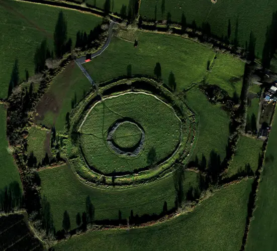
Unofficial guide. Not the National Monuments Service, the OPW, Fáilte Ireland or the landowner. Disclaimer
At a glance
- TypeHillfort
What to look for
- Bank and ditch
- Entrance gap
- Ramparts
Picked out from the Archaeological Survey description below.
Can you visit?
- No source says it is open to the public.Most monuments in Ireland stand on private farmland.
- Ask the landowner before crossing fields, close gates, leave the stones as you find them.Visiting responsibly
History and description
Situated on top of Laghtea Hill with extensive views in all directions.
Full archaeological record 566 words
Situated on top of Laghtea Hill with extensive views in all directions. A large irregular-shaped area enclosed by two earth and stone banks with intervening fosse (Wth 2.5m) visible from S through W to N. The natural fall of the cliff-edge forms the defensive feature at E. The inner bank (Wth 2.5m; int. H 0.7m; ext. H 2.5m) is the best preserved while the outer bank (Wth 2.5m; int. H 0.5m) is covered by peat and furze. The ground surface in the interior is very rugged, occupied largely by rock outcrop. There is a low circular platform (diam. c.20m) containing a stone-edged wall at the N end of the hillfort interior, possibly contemporary with the hillfort construction (Condit 1995, 37). Possible causewayed entrance feature at W. The hillfort was recently described in the Atlas of Hillforts of Britain and Ireland as following; 'Irregular shaped contour fort surrounding two summits of Laghtea Hill. The enclosing elements are positioned at the base of a steep incline. In commanding position overlooking the S fording point of Lough Derg and with panoramic views from the summit. Bivallate for the entire perimeter with no enclosing elements at SE. The site has a total foot print of 7.8ha. There is a possible original entrance at the W (Condit 1995, 37). Walking track breaks through enclosing elements at S. Low circular platform with well within interior to the N. No other features visible on the surface. Ramparts survive well throughout, however, heavy overgrowth largely conceals the enclosing elements. First identification and monument survey by Condit (1995). The hillfort is not depicted in any historic mapping. Modern walking track breaks through enclosing elements at the S and extends to the N summit where a large cross has been erected. Small modern structure has been near the N summit of the interior. Commercial forestry plantation abutting enclosing elements at W and SW. Hillfort interior heavily overgrown and under light blanket bog. Large areas of rock outcrop near summits. Boundary seperating the townlands of Laghtea and Cloneybrien runs N - S through the center of the hillfort. The S section of the enclosing elements forms the intersection between the two aforementioned townland boundaries and Townlough Upper townland to the S.' (http://hillforts.arch.ox.ac.uk/records/IR0714.html)
Site inspection by Anne Carey, Archaeologist, NMS on the 25/02/2022 noted that; 'Laghtea Hill is accessible via a man-made unbound path which was constructed in c. 2002, with additional works in c. 2015, and which has developed into a very popular walking route, known as the Millennium Cross and Lough Derg Circular (AllTrails). The 3m wide walking path rose in a generally north-easterly direction, with some meanders included, but the point at which it crossed into the hillfort could be seen from the map in Tom Condit’s publication. The path continued to the summit of the hill, past a masonry built, poorly preserved cross base, dating to 1932, to a new cross, erected in 2002. Named the Millennium Cross, it has a man-made foundation measuring c. 9m x 9m. In addition it has four wire stays, anchored to the ground outside the foundation area and there is fixed signage overlooking the scenic view of Lough Derg as well as a tubular metal bench, all necessitating ground works within the area of the hillfort. Steep steps, which were constructed in c. 2015, descend the hillside from the Millennium Cross, continuing the walking trail to the north-west.
References
- Date of revised upload: 1 June 2022
Archaeological Survey of Ireland, National Monuments Service (CC BY 4.0) · Compiled by Jean Farrelly and Caimin O'Brien · Based on the The Archaeological Inventory of County Tipperary. Vol. 1 - North Tipperary' compiled by Jean Farrelly and Caimin O'Brien. It describes the site as it was when surveyed.
More hillforts nearby
Ballincurra
Hillfort · Ballincurra,Killeen (Kilnaneave Par.),Kilnaneave · Tipperary · 21 km away
Garrangrena Lower
Hillfort · Garrangrena Lower · Tipperary · 29 km away
Visitors' notes
Badges are opinions of visitors - not verified facts. One vote per badge and visitor; no account needed.
Best time to visit
What's missing on this page?
Share a tip to find it
Share a local tradition or story
Suggest a correction
Suggest the right map location
Report a duplicate page
Ask a question
Do not include personal data. See our privacy notice.
Around Laghtea
Other heritage nearby
- Fintan's GraveCave · 2.0 km
- Castletown Church, County TipperaryAncient church · 2.1 km
- Garrykennedy tower houseCastle · 5.6 km
- Brian Boru's FortRingfort · 6.4 km
- Lady WellHoly well · 6.6 km
- St Brigid's ChurchAncient church · 6.7 km
Recorded within 5 km
- 35 ringfortsArchaeological Survey of Ireland
- 6 castlesArchaeological Survey of Ireland
- 6 standing stonesArchaeological Survey of Ireland
- 4 ancient churchesArchaeological Survey of Ireland
- 2 holy wellsArchaeological Survey of Ireland
- 2 megalithic tombsArchaeological Survey of Ireland
- 1 caveArchaeological Survey of Ireland
- 1 monastic siteArchaeological Survey of Ireland
- 1 stone circleArchaeological Survey of Ireland
Walks and trails
- Arra Mountains LoopWalking Trail · 12.4 km · nearest point 0.0 km
- Lough Derg Blueway - Castlelough to KillaloePaddling Trail · 11.8 km · nearest point 1.3 km
- Graves of the Leinster Men Looped WalkWalking Trail · 5.6 km · nearest point 1.5 km
Outdoors, towns and places to stay
- BallycuggaranForests · 5.9 km
- Doonane/Keeper HillForests · 15 km
- BallycuggeranBeaches · 5.6 km · Excellent Quality (2025)
- Mountshannon, Lough DergBeaches · 7.5 km · Excellent Quality (2025)
- Derrycrag Wood Nature ReserveNature reserves · 20 km
- NenaghWalled towns · 13 km
Other attractions nearby
- UL Sport Adventure CentreWalking · 5.6 km
- Ballycuggeran BeachNature and Wildlife · 5.9 km
- Holy IslandHistoric Houses and Castle · 6.8 km
- The ApproachWalking · 6.9 km
Excavations nearby
- E2483 Ballycuddy More Site 1, County TipperaryRoad-scheme excavation report (TII) · 7.7 km
- E2480 Cloghleigh Site 1, County TipperaryRoad-scheme excavation report (TII) · 7.7 km