
Unofficial guide. Not the National Monuments Service, the OPW, Fáilte Ireland or the landowner. Disclaimer
At a glance
- TypeHillfort
What to look for
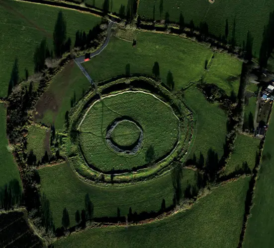
- Bank and ditch
- Entrance gap
- Ramparts
Picked out from the Archaeological Survey description below.
Can you visit?
- No source says it is open to the public.Most monuments in Ireland stand on private farmland.
- Ask the landowner before crossing fields, close gates, leave the stones as you find them.Visiting responsibly
History and description
Situated on a hilltop in a mountainous area with a nearby ringfort (TN028-071----) to the E. A heather-covered hillfort (diam. 145m N-S) enclosed by a fosse (Wth 1m; D 0.2m), an earth and stone bank (Wth 2m; int. H 1m; ext. H 1m) and an outer fosse (Wth 1-3m; ext. D 0.3m) with a possible entrance gap (Wth 3m) at W. A field fence bisects the site on a N-S axis.
Full archaeological record 202 words
Situated on a hilltop in a mountainous area with a nearby ringfort (TN028-071----) to the E. A heather-covered hillfort (diam. 145m N-S) enclosed by a fosse (Wth 1m; D 0.2m), an earth and stone bank (Wth 2m; int. H 1m; ext. H 1m) and an outer fosse (Wth 1-3m; ext. D 0.3m) with a possible entrance gap (Wth 3m) at W. A field fence bisects the site on a N-S axis. There is no apparent attempt to flatten the interior - the natural slope of the hilltop is maintained.
The hillfort was recently described in the Atlas of Hillforts of Britain and Ireland as following; 'In commanding position surrounding domed summit of hilltop following natural contours of hill. Overlooking Moanamaddra Lough to E and Fishmoyne River to E and SE. Univallate for the entire circuit, the hillfort comprises two ditches with an intervening bank. The site has a total foot print of about 2.1ha. There is a possible entrance at the W comprising a simple 3m break in the enclosing elements. There are no other recorded entrance features. The ramparts survive well throughout its circuit. The interior is under blanket bog and heather. First map identification in second edition Ordnance Survey mapping.'(http://hillforts.arch.ox.ac.uk/records/IR0710.html)
References
- Date of revised upload: 6 February 2020
Archaeological Survey of Ireland, National Monuments Service (CC BY 4.0) · Compiled by Jean Farrelly and Caimin O'Brien · Based on the The Archaeological Inventory of County Tipperary. Vol. 1 - North Tipperary' compiled by Jean Farrelly and Caimin O'Brien. It describes the site as it was when surveyed.
More hillforts nearby
Ballincurra
Hillfort · Ballincurra,Killeen (Kilnaneave Par.),Kilnaneave · Tipperary · 8.3 km away
Laghtea
Hillfort · Cloneybrien,Laghtea,Townlough Upper · Tipperary · 29 km away
Visitors' notes
Badges are opinions of visitors - not verified facts. One vote per badge and visitor; no account needed.
Best time to visit
What's missing on this page?
Share a tip to find it
Share a local tradition or story
Suggest a correction
Suggest the right map location
Report a duplicate page
Ask a question
Do not include personal data. See our privacy notice.
Around Garrangrena Lower
Other heritage nearby
- Castle OtwayCastle · 6.1 km
- Killanna WellHoly well · 8.5 km
Recorded within 5 km
- 64 ringfortsArchaeological Survey of Ireland
- 8 castlesArchaeological Survey of Ireland
- 6 ancient churchesArchaeological Survey of Ireland
- 2 holy wellsArchaeological Survey of Ireland
Walks and trails
- Ormond WayLong Distance Waymarked Way · 74.6 km · nearest point 3.6 km
- Ormond Way Cycle RouteRoad Cycling Trail · 76.2 km · nearest point 4.1 km
- Devils Bit LoopWalking Trail · 3.8 km · nearest point 5.4 km
Other attractions nearby
- Fairy Fort FarmNature and Wildlife · 3.4 km
- Tipperary Mountain Trekking CentreNature and Wildlife · 5.9 km