
Unofficial guide. Not the National Monuments Service, the OPW, Fáilte Ireland or the landowner. Disclaimer
At a glance
- TypeHillfort
- Recorded sizeW 1.8m; int. H 0.69m; ext. H 1.73m
What to look for
- Bank and ditch
- Entrance gap
- Ramparts
Picked out from the Archaeological Survey description below.
Can you visit?
- No source says it is open to the public.Most monuments in Ireland stand on private farmland.
- Ask the landowner before crossing fields, close gates, leave the stones as you find them.Visiting responsibly
History and description
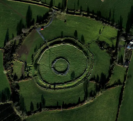
Situated on the summit of Ballincurra Hill with panoramic views in all directions; Knockadigeen hillfort (TN027-098001-) is to the NE. A large, oval hillfort (max. diam. c. 120m NE-SW; 102m NW-SE) defined by a bank (Wth 1.8m; int. H 0.69m; ext. H 1.73m) and outer fosse (Wth 2-3m; D 0.55m) with a cairn (TN027-140002-) in the interior. The fosse at E has a V-shaped profile, 2m wide at the base, which broadens out to 3m.
Full archaeological record 268 words
Situated on the summit of Ballincurra Hill with panoramic views in all directions; Knockadigeen hillfort (TN027-098001-) is to the NE. A large, oval hillfort (max. diam. c. 120m NE-SW; 102m NW-SE) defined by a bank (Wth 1.8m; int. H 0.69m; ext. H 1.73m) and outer fosse (Wth 2-3m; D 0.55m) with a cairn (TN027-140002-) in the interior. The fosse at E has a V-shaped profile, 2m wide at the base, which broadens out to 3m. The bank is composed of earth with some stone protruding from the surface. In the SE quadrant the hillfort is defined by a scarp (H 2.6m) cut into the natural rock with no visible external fosse. Most of the SW portion of the hillfort is covered in forestry, S of the field and townland boundary on the OS 6-inch map.
The hillfort was recently described in the Atlas of Hillforts of Britain and Ireland as following; 'Univallate contour fort surrounding the domed summit of mountain at the N edge of the Silvermines Mountain range. Knockadiggeen hillfort 1.4km to NE (Atlas No.0713). The site has a total site footprint of approximately 1.1ha. Univallate for the entire circuit with no recorded entrance features. There is a heather covered cairn near the centre of the hillfort. There are no recorded entrance features. Ramparts survive best at NE. Commercial forestry plantation covers approximately two thirds of the hillfort. The remainder is under heavy heather growth. First map detection in second edition Ordnance Survey mapping. Monument surveyed by Farrelly and O'Brien (2002). At the center of the hillfort, the townland boundaries of Ballincurra, Killeen and Kilnaneave meet.' (http://hillforts.arch.ox.ac.uk/records/IR0708.html).
References
- Date of revised upload: 6 February 2020
Archaeological Survey of Ireland, National Monuments Service (CC BY 4.0) · Compiled by Jean Farrelly and Caimin O'Brien · Based on the The Archaeological Inventory of County Tipperary. Vol. 1 - North Tipperary' compiled by Jean Farrelly and Caimin O'Brien. It describes the site as it was when surveyed.
More hillforts nearby
Garrangrena Lower
Hillfort · Garrangrena Lower · Tipperary · 8.3 km away
Laghtea
Hillfort · Cloneybrien,Laghtea,Townlough Upper · Tipperary · 21 km away
Visitors' notes
Badges are opinions of visitors - not verified facts. One vote per badge and visitor; no account needed.
Best time to visit
What's missing on this page?
Share a tip to find it
Share a local tradition or story
Suggest a correction
Suggest the right map location
Report a duplicate page
Ask a question
Do not include personal data. See our privacy notice.
Around Ballincurra
Other heritage nearby
- Castle OtwayCastle · 2.2 km
- Priory and Hospital of St. John the BaptistAbbey or friary · 9.7 km
Recorded within 5 km
- 93 ringfortsArchaeological Survey of Ireland
- 6 standing stonesArchaeological Survey of Ireland
- 6 castlesArchaeological Survey of Ireland
- 5 ancient churchesArchaeological Survey of Ireland
- 1 hillfortArchaeological Survey of Ireland
- 1 monastic siteArchaeological Survey of Ireland
- 1 megalithic tombArchaeological Survey of Ireland
Walks and trails
- Ormond Way Cycle RouteRoad Cycling Trail · 76.2 km · nearest point 1.9 km
- Ormond WayLong Distance Waymarked Way · 74.6 km · nearest point 4.3 km
- Slieve Felim WayLong Distance Waymarked Way · 44.6 km · nearest point 7.7 km
Outdoors, towns and places to stay
- Dromineer BeachBeaches · 20 km · Good Quality (2025)
- NenaghWalled towns · 11 km
Other attractions nearby
- Tipperary Mountain Trekking CentreNature and Wildlife · 9.3 km
- Lough Derg Blueway EastNature and Wildlife · 11 km
- Fairy Fort FarmNature and Wildlife · 11 km
- Nenagh CastleHistoric Houses and Castle · 11 km