


Unofficial guide. Not the National Monuments Service, the OPW, Fáilte Ireland or the landowner. Disclaimer
At a glance
- TypeOgham stone
- Recorded sizeH 2.1m; W 0.8m; T 0.5m
What to look for
- Ogham inscription
Picked out from the Archaeological Survey description below.
Can you visit?
- No source says it is open to the public.Most monuments in Ireland stand on private farmland.
- Ask the landowner before crossing fields, close gates, leave the stones as you find them.Visiting responsibly
History and description
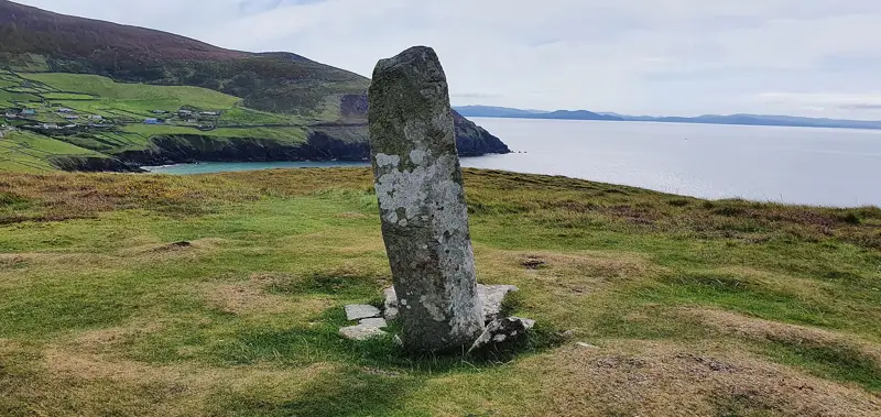
On a SE-facing slope, E of Saddle Hill, in the centre of a large field. A large grit pillar (H 2.1m; Wth 0.8m; T 0.5m) with an ogham inscription on both edges of the W face, which has 'suffered badly from cattle and weather-wear' (Macalister 1945, 36, no. 31).
Full archaeological record 60 words
On a SE-facing slope, E of Saddle Hill, in the centre of a large field. A large grit pillar (H 2.1m; Wth 0.8m; T 0.5m) with an ogham inscription on both edges of the W face, which has 'suffered badly from cattle and weather-wear' (Macalister 1945, 36, no. 31). Macalister transcribed the inscription as: DRUGNO MAQI MUCOI [--] NAMI (ibid.).
Archaeological Survey of Ireland, National Monuments Service (CC BY 4.0) · Compiled by Nora White · Updated 3 May 2016. It describes the site as it was when surveyed.
More ogham stones nearby

Tullaherin II (Ogham Stone Concept by the Ogham in 3D Project)
Ogham stone · Tullaherin · Kilkenny · 8.9 km away
CIIC 32 (Ogham Stone Concept by RAS Macalister)
Ogham stone · Gowran · Kilkenny · 12 km away
 National Monument
Ballyboodan Ogham Stone
Ogham stone · Ballyboodan · Kilkenny · 14 km away
Also recorded nearby
Named sites within 5 km with only a short entry in the Archaeological Survey.
- St. Michael's WellRitual site - holy well · Cappagh (Gowran By.) · 2.6 km · official record
- Cloghscregg CastleCastle - tower house · Cloghscregg · 3.0 km · official record
- Kilcullen ChurchChurch · Kilcullen · 3.6 km · official record
- Holy Cross wellRitual site - holy well · Kilcross · 3.9 km · official record
- Priory of InistiogeReligious house - Augustinian canons · Inistioge · 4.2 km · official record
- fortified houseHouse - fortified house · Inistioge · 4.2 km · official record
- Columbkille's WellRitual site - holy well · Inistioge · 4.2 km · official record
- fortified houseHouse - fortified house · Inistioge · 4.3 km · official record
Visitors' notes
Badges are opinions of visitors - not verified facts. One vote per badge and visitor; no account needed.
Best time to visit
What's missing on this page?
Share a tip to find it
Share a local tradition or story
Suggest a correction
Suggest the right map location
Report a duplicate page
Ask a question
Do not include personal data. See our privacy notice.
Around Ogham Stone Fiddaun Upper
Other heritage nearby
- St Kieran's WellHoly well · 1.3 km
- St. Kieran's WellHoly well · 1.9 km
- ToberelleenHoly well · 3.6 km
- Kilfane Glen and WaterfallWaterfall · 4.8 km
- St. Michael's WellHoly well · 5.7 km
- Saint Michael's ChurchAncient church · 5.8 km
Recorded within 5 km
- 7 castlesArchaeological Survey of Ireland
- 7 ancient churchesArchaeological Survey of Ireland
- 6 holy wellsArchaeological Survey of Ireland
- 4 ringfortsArchaeological Survey of Ireland
- 1 standing stoneArchaeological Survey of Ireland
- 1 monastic siteArchaeological Survey of Ireland
- 1 abbey or friaryArchaeological Survey of Ireland
- 1 waterfallArchaeological Survey of Ireland
- 1 hillfortArchaeological Survey of Ireland
Walks and trails
- East Kilkenny Cycle RouteRoad Cycling Trail · 62.6 km · nearest point 3.2 km
- Nore Valley Walk - Inistioge to Thomastown SectionLong Distance Waymarked Way · 10.9 km · nearest point 3.5 km
- Brandon Hill LoopWalking Trail · 15.7 km · nearest point 3.8 km
Outdoors, towns and places to stay
- InistiogeWalled towns · 4.2 km
- ThomastownWalled towns · 6.8 km
Other attractions nearby
- Kilfane Glen and WaterfallGardens · 4.8 km
- Duiske AbbeyHistoric Houses and Castle · 6.0 km
- Riverboat AdventuresNature and Wildlife · 6.1 km
- Kilfane ChurchHistoric Houses and Castle · 6.5 km