
Unofficial guide. Not the National Monuments Service, the OPW, Fáilte Ireland or the landowner. Disclaimer
At a glance
- TypeHillfort
- Recorded sizeint. H 0.6m; ext. H 1.4m
What to look for
- Bank and ditch
Picked out from the Archaeological Survey description below.
Can you visit?
- No source says it is open to the public.Most monuments in Ireland stand on private farmland.
- Ask the landowner before crossing fields, close gates, leave the stones as you find them.Visiting responsibly
History and description
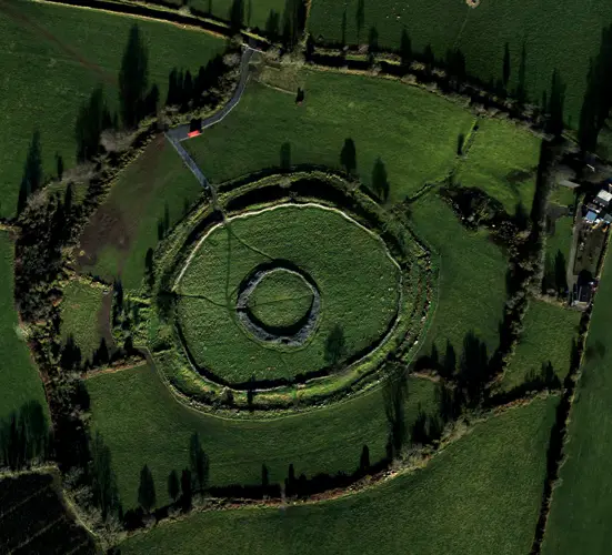
At summit of Claragh Mountain, with extensive view in all directions. Subcircular area (122m E-W; 122m N-S) defined by rubble stone bank (int. H 0.6m; ext. H 1.4m), best preserved NNE->SW; low SW->W; slight traces W->NNE.
Full archaeological record 139 words
At summit of Claragh Mountain, with extensive view in all directions. Subcircular area (122m E-W; 122m N-S) defined by rubble stone bank (int. H 0.6m; ext. H 1.4m), best preserved NNE->SW; low SW->W; slight traces W->NNE. Possible gap (Wth 8m) to WNW. Close to centre of interior, subrectangular enclosure (19m ENE-WSW; 14m NNW-SSE) defined by band of rubble stone (Wth 1.5m); cairn (diam. 8m; H 0.5m) (CO039-052001-) overlies W corner of enclosure. According to local tradition, priest buried here (Broker 1937, 45) 'c. 300 years ago' (Bowman 1934, 318). In 2014, in the process of erecting a cross at the summit, sections of the enclosing bank were removed at NE and SW. Other recent damage within the interior of the monument appears to have been caused during the installation of a telecom station, OS trigonometrical station and ESB poles.
Archaeological Survey of Ireland, National Monuments Service (CC BY 4.0) · Compiled by Matt Kelleher · Updated 13 October 2014 · Based on the Archaeological Inventory of County Cork. Volume 4: North Cork. It describes the site as it was when surveyed.
Folklore and traditions
According to local tradition, priest buried here (Broker 1937, 45) 'c. 300 years ago' (Bowman 1934, 318).
Visitors' notes
Badges are opinions of visitors - not verified facts. One vote per badge and visitor; no account needed.
Best time to visit
What's missing on this page?
Share a tip to find it
Share a local tradition or story
Suggest a correction
Suggest the right map location
Report a duplicate page
Ask a question
Do not include personal data. See our privacy notice.
Around Claragh
Other heritage nearby
- Nohaval early Christian monastic siteMonastic site · 9.3 km
- Nohaval Round TowerRound tower · 9.3 km
Recorded within 5 km
- 116 ringfortsArchaeological Survey of Ireland
- 22 standing stonesArchaeological Survey of Ireland
- 5 stone circlesArchaeological Survey of Ireland
- 4 ancient churchesArchaeological Survey of Ireland
- 2 holy wellsArchaeological Survey of Ireland
- 2 castlesArchaeological Survey of Ireland
- 2 ogham stonesArchaeological Survey of Ireland
Walks and trails
- Claragh Loop (Millstreet)Walking Trail · 8.7 km · nearest point 0.3 km
- Duhallow WayLong Distance Waymarked Way · 74.0 km · nearest point 0.9 km
- Boherbue Looped WalkWalking Trail · 4.0 km · nearest point 11 km
Outdoors, towns and places to stay
- The Gearagh Nature ReserveNature reserves · 19 km
- GlenlohaneHistoric stays · 25 km
Other attractions nearby
- Millstreet MuseumMuseums and Attraction · 2.2 km