
Unofficial guide. Not the National Monuments Service, the OPW, Fáilte Ireland or the landowner. Disclaimer
At a glance
- TypeHillfort
What to look for
- Bank and ditch
- Entrance gap
- Ramparts
Picked out from the Archaeological Survey description below.
Can you visit?
- No source says it is open to the public.Most monuments in Ireland stand on private farmland.
- Ask the landowner before crossing fields, close gates, leave the stones as you find them.Visiting responsibly
History and description
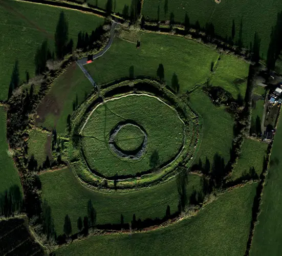
Situated on the summit of a hill known locally as 'The Hill of Mael' with panoramic views of the surrounding countryside in all directions. Cashel (WM003-008----) standing inside a large possible trivallate hillfort (overall diam. 370m E-W) with possible prehistoric field system (WM003-008002-) running across the hill and St Brigid's holy well (WM003-008003-) located below S summit of hilltop (Adams 1957, 45).
Full archaeological record 413 words
Situated on the summit of a hill known locally as 'The Hill of Mael' with panoramic views of the surrounding countryside in all directions. Cashel (WM003-008----) standing inside a large possible trivallate hillfort (overall diam. 370m E-W) with possible prehistoric field system (WM003-008002-) running across the hill and St Brigid's holy well (WM003-008003-) located below S summit of hilltop (Adams 1957, 45). The enclosing elements of the hillfort appear to represent a mixture of natural geological features which have been scarped and an earthen bank and fosse which is best visible at E where it forms a boundary with the modern forestry plantation. A band of rock outcrop on the W side of the hilltop appears to form a natural enclosing element. The enclosing features of the hillfort appear to follow the natural contours of the hill which is defined by rock outcropping best visible on SW and W face of hill. On this side of the hilltop at least two bands of rock outcrop can be seen running around the hill from SW-W only. These bands of natural rock outcrop following the contour of the hill may have been scarped and possibly represent the enclosing elements of the hillfort which would give the monument a trivallate appearance. A ditch and bank of the outermost enclosing feature is visible from W to NW on Digital Globe aerial photograph taken November 2011. The remains of meandering drystone field walls possibly of prehistoric date radiate out from the inner enclosure at NNE and NNW. The larger outer enclosing contours of the hillfort are clearly visible on Digital Globe aerial photograph taken November 2011 and on an aerial photograph taken in 1964 (CUCAP AJO061) (http://www.cambridgeairphotos.com/location/ajo061/).
Recently described in the Atlas of Hillforts of Britain and Ireland as following; ‘Circular contour fort with a total site footprint of approximately 0.3ha positioned at the summit of The Hill of Mael with panoramic views from the summit and low-lying terrain to the W. Univallate for the entire circuit with no obvious entrance features recorded. A number of unrecorded features within the interior of the fort are visible in most aerial photographs. These comprise a central circular enclosure and two linear features leading SE from it to meet the enclosing elements of the contour fort. These are likely to be of archaeological significance and may be contemporary with the fort. The ramparts survive well throughout. The interior is under pasture. First map depiction in second edition Ordnance Survey mapping.’ (http://hillforts.arch.ox.ac.uk/records/IR1007.html)
Archaeological Survey of Ireland, National Monuments Service (CC BY 4.0) · Compiled by Caimin O'Brien · Updated 23 November 2017. It describes the site as it was when surveyed.
Folklore and traditions
Visitors' notes
Badges are opinions of visitors - not verified facts. One vote per badge and visitor; no account needed.
Best time to visit
What's missing on this page?
Share a tip to find it
Share a local tradition or story
Suggest a correction
Suggest the right map location
Report a duplicate page
Ask a question
Do not include personal data. See our privacy notice.
Around Bigwood
Other heritage nearby
- St Brigid's WellHoly well · 0.0 km
- Lady WellHoly well · 2.7 km
- Tullynally CastleCastle · 5.9 km
- ForeAbbey or friary · 8.0 km
- Abbeylara Cistercian AbbeyAbbey or friary · 9.4 km
- Abbeylara MonasteryAncient church · 9.5 km
Recorded within 5 km
- 72 ringfortsArchaeological Survey of Ireland
- 17 castlesArchaeological Survey of Ireland
- 5 ancient churchesArchaeological Survey of Ireland
- 4 holy wellsArchaeological Survey of Ireland
- 3 monastic sitesArchaeological Survey of Ireland
- 2 megalithic tombsArchaeological Survey of Ireland
- 1 standing stoneArchaeological Survey of Ireland
- 1 hillfortArchaeological Survey of Ireland
Walks and trails
- Mullaghmeen White WalkWalking Trail · 8.1 km · nearest point 2.0 km
- Mullaghmeen Yellow WalkWalking Trail · 1.7 km · nearest point 2.6 km
- Mullaghmeen Red WalkWalking Trail · 3.5 km · nearest point 2.9 km
Outdoors, towns and places to stay
- Mullaghmeen ForestForests · 2.9 km
- The Cut, Lough LeneBeaches · 11 km · Excellent Quality (2025)
- Portnashangan, Lough OwelBeaches · 18 km · Excellent Quality (2025)
- Scragh Bog Nature ReserveNature reserves · 18 km
- ForeWalled towns · 8.2 km
- Lough Bishop HouseHistoric stays · 11 km
Other attractions nearby
- MullaghmeenWalking · 3.3 km
- Fore AbbeyHistoric Houses and Castle · 8.0 km
What's on nearby
- Good Girls by Clare Monnelly2026-11-12 · 19 km
- Good Girls by Clare Monnelly2026-11-13 · 19 km
- Good Girls by Clare Monnelly2026-11-14 · 19 km