
Unofficial guide. Not the National Monuments Service, the OPW, Fáilte Ireland or the landowner. Disclaimer
At a glance
- TypeStone circle - embanked
What to look for
- Stones still standing
Picked out from the Archaeological Survey description below.
Can you visit?
- No source says it is open to the public.Most monuments in Ireland stand on private farmland.
- Ask the landowner before crossing fields, close gates, leave the stones as you find them.Visiting responsibly
History and description
On a ridge in pastureland, immediately to the S of the Loughrea-Portumna road. Named the ‘Seven Monuments’ and shown within a large mixed forest on the OS 6-inch maps, this National Monument was known locally as 'Feara Breige'.
Full archaeological record 443 words
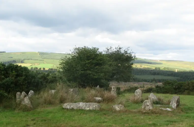
On a ridge in pastureland, immediately to the S of the Loughrea-Portumna road. Named the ‘Seven Monuments’ and shown within a large mixed forest on the OS 6-inch maps, this National Monument was known locally as 'Feara Breige'. It was described in Dutton’s Statistical Survey of 1824 as a mound where there were ‘formerly eight flat rude stones’, but one was missing, five were still standing and two were lying flat on the bank. In the centre was a ‘tumulus’ and the entire site was planted with trees (O'Flanagan 1927, Vol. 2, 239). The trees have since been removed from the monument but traces of the plantation survive immediately to its S and around its W limits and a house has been built to its SE. Traces of lazy beds, running roughly NE-SW are visible immediately to its S. This embanked stone circle (30.15m N-S) is defined by a raised roughly circular area that is enclosed by a well-preserved mainly earthen flat-topped bank (Wth at N 0.8m; int. H 0.5m; ext. H 0.8m) that is clearly visible all round. An outhouse built in the early 1980s clips it a SE (SMR file). There is small gap (base Wth 0.7m) in the bank at SE. The seven boulders are still extant: two at NW and N are lying flat and the other five at NE, E, SE, SSE and SSW are upright. Within the interior, roughly centrally located, is a small cairn (1.8m N-S; H 0.35-0.7m). A low berm (Wth 11.7m) visible around it slopes gently towards the bank. There is no visible surface trace of a fosse. Knox (1915, 310-11) recorded traces of an outer bank to the N, E and S. It is now only clearly visible from N to NE (L c. 16.4m; Wth 0.5m; int. H 1.7m; ext. H 1m). Here a field wall is built outside it and there is a sharp drop (H 1.8m) to the road below. Otherwise only slight intermittent traces are evident from SW to N and this area is densely overgrown with scrub and trees. Knox (1915-16, 72) suggested that the central cairn was possibly an Ordnance Survey station and an excavation by Macalister (1916-17, 506-7), which proved that it was of recent origin, may back this up. The upstanding stones range in height from 1.08m to 1.56m and packing stones are visible at the base of some. Most are partially covered with moss and lichen. The top of the stone (L c. 0.2m; Wth 0.2m) at WSW is fairly flat and bears a roughly square tenon-like feature (H 0.02m; L 0.05m; Wth 0.05m), again suggesting a possible link with an OS trigonometrical station.
References
- This monument is subject to a preservation order made under the National Monuments Acts 1930 to 2014 (PO no. 173/1943).
- The monument was taken into Guardianship under the National Monuments Acts 1930 to 2014 - National Monument 398.
Archaeological Survey of Ireland, National Monuments Service (CC BY 4.0) · Compiled by Olive Alcock · Updated 8 October 2018. It describes the site as it was when surveyed.
Also recorded nearby
Named sites within 5 km with only a short entry in the Archaeological Survey.
- Tonaroasty CashelRingfort - cashel · Tonaroasty · 1.1 km · official record
This monument is subject to a preservation order made under the National Monuments Acts 1930 to 2014 (PO no. 9/1985).
- St. Mary's PrioryReligious house - Carmelite friars · Loughrea · 2.9 km · official record
- Kilmeen Round TowerRound tower · Kilmeen · 2.9 km · official record
- Leitrim ChurchChurch · Carrowkeel (Leitrim By.) · 4.6 km · official record
Visitors' notes
Badges are opinions of visitors - not verified facts. One vote per badge and visitor; no account needed.
Best time to visit
What's missing on this page?
Share a tip to find it
Share a local tradition or story
Suggest a correction
Suggest the right map location
Report a duplicate page
Ask a question
Do not include personal data. See our privacy notice.
Around The Seven Monuments
Other heritage nearby
- RathsoonyRingfort · 1.6 km
- RahannagraghRingfort · 1.7 km
- St Bridget's WellHoly well · 2.3 km
- Lady's WellHoly well · 3.2 km
- St. Dima's WellHoly well · 3.5 km
- St Dympna's ChurchAncient church · 3.9 km
Recorded within 5 km
- 73 ringfortsArchaeological Survey of Ireland
- 10 castlesArchaeological Survey of Ireland
- 8 ancient churchesArchaeological Survey of Ireland
- 7 holy wellsArchaeological Survey of Ireland
- 4 standing stonesArchaeological Survey of Ireland
- 2 hillfortsArchaeological Survey of Ireland
- 2 abbeys & friariesArchaeological Survey of Ireland
- 1 megalithic tombArchaeological Survey of Ireland
- 1 monastic siteArchaeological Survey of Ireland
- 1 round towerArchaeological Survey of Ireland
Walks and trails
- Slieve Aughty Trails - Sonnagh Old LoopWalking Trail · 7.3 km · nearest point 7.1 km
- Slieve Aughty Trails - Gortnamanagh LoopWalking Trail · 6.5 km · nearest point 7.4 km
- Slieve Aughty Trails - Old Curragh RoadWalking Trail · 1.3 km · nearest point 9.4 km
Outdoors, towns and places to stay
- Loughrea LakeBeaches · 2.2 km · Excellent Quality (2025)
- Pollnaknockaun Wood Nature ReserveNature reserves · 17 km
- Rosturra Wood Nature ReserveNature reserves · 18 km
- LoughreaWalled towns · 2.8 km
Other attractions nearby
- Loughrea CathedralAbbeys and Monastery · 2.6 km
- Loughrea LakeBeach · 3.0 km
- Finnerty's MillsHistoric Houses and Castle · 5.5 km
- Slieve Aughty Riding CentreNature and Wildlife · 7.2 km
Excavations nearby
- E1532 Fairfield, County GalwayRoad-scheme excavation report (TII) · 1.9 km
- E1506 Greeneenagh, County GalwayRoad-scheme excavation report (TII) · 2.2 km