


Unofficial guide. Not the National Monuments Service, the OPW, Fáilte Ireland or the landowner. Disclaimer
At a glance
- TypeStone circle - multiple-stone
- StatusNational Monument
What to look for
- Stones still standing
- Alignment
Picked out from the Archaeological Survey description below.
Can you visit?
- No source says it is open to the public.Most monuments in Ireland stand on private farmland.
- Ask the landowner before crossing fields, close gates, leave the stones as you find them.Visiting responsibly
History and description
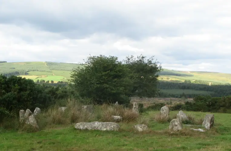
On level patch of rough pasture on SE slopes of Miskish mountain. Circle incomplete; may have consisted of fifteen stones.
Full archaeological record 56 words
On level patch of rough pasture on SE slopes of Miskish mountain. Circle incomplete; may have consisted of fifteen stones. Twelve survive, three of these prostrate. Orthostats are 0.4m to 2.4m L, 0.15m to 0.3m T and 1.25m to 1.9m H. Internal measurement along mains axis, aligned E-W, is 7.8m. (Ó Nualláin 1984, 20, no. 26)
References
- Image provided by and copyright of Amanda Clarke 2016-2022 https://holywellscorkandkerry.com/
Archaeological Survey of Ireland, National Monuments Service (CC BY 4.0) · Updated 14 January 2009 · Based on the Archaeological Inventory of County Cork. Volume 1: West Cork. It describes the site as it was when surveyed.
More stone circles nearby
Visitors' notes
Badges are opinions of visitors - not verified facts. One vote per badge and visitor; no account needed.
Best time to visit
What's missing on this page?
Share a tip to find it
Share a local tradition or story
Suggest a correction
Suggest the right map location
Report a duplicate page
Ask a question
Do not include personal data. See our privacy notice.
Around Derreenataggart
Other heritage nearby
- Castletownbere HarbourCastle · 1.5 km
- Ballcrovane ogham stoneOgham stone · 6.6 km
- Kilcatherine ChurchAncient church · 7.4 km
Recorded within 5 km
- 56 standing stonesArchaeological Survey of Ireland
- 16 ringfortsArchaeological Survey of Ireland
- 6 megalithic tombsArchaeological Survey of Ireland
- 5 holy wellsArchaeological Survey of Ireland
- 4 ancient churchesArchaeological Survey of Ireland
- 2 castlesArchaeological Survey of Ireland
- 1 promontory fortArchaeological Survey of Ireland
- 1 ogham stoneArchaeological Survey of Ireland
- 1 stone circleArchaeological Survey of Ireland
- 1 monastic siteArchaeological Survey of Ireland
Walks and trails
- Bullig Bay LoopWalking Trail · 4.2 km · nearest point 2.6 km
- Bere Island - Ardnakinna - West Island LoopWalking Trail · 7.6 km · nearest point 2.6 km
- Eyeries - Creha Quay LoopWalking Trail · 4.6 km · nearest point 4.7 km
Outdoors, towns and places to stay
- DunboyForests · 2.7 km
- GarnishBeaches · 15 km
- Dooneen PierBeaches · 17 km
Other attractions nearby
- Castletownbere HarbourNatural Landscape · 1.4 km
- GourNatural Landscape · 4.6 km
- Pontoon PierIsland · 5.1 km
- Allihies Copper Mine TourWalking · 8.2 km