


Unofficial guide. Not the National Monuments Service, the OPW, Fáilte Ireland or the landowner. Disclaimer
At a glance
- TypeStone circle - multiple-stone
- Recorded sizeH 0.4m; 0.9m x 0.6m
- StatusNational Monument
What to look for
- Recumbent stone
- Stones still standing
- Alignment
Picked out from the Archaeological Survey description below.
Can you visit?
- No source says it is open to the public.Most monuments in Ireland stand on private farmland.
- Ask the landowner before crossing fields, close gates, leave the stones as you find them.Visiting responsibly
History and description
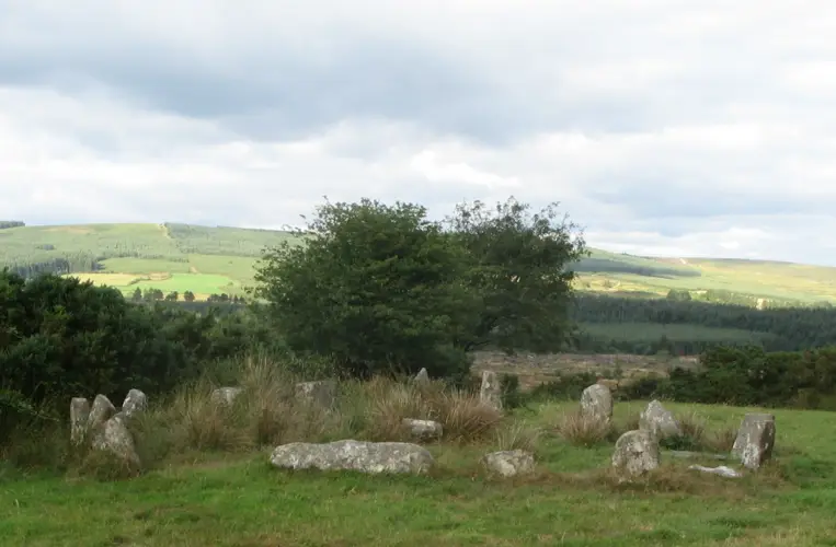
On level patch in gently sloping pasture, on W side of Laney River basin. Circle incomplete; may have consisted of seventeen stones.
Full archaeological record 82 words
On level patch in gently sloping pasture, on W side of Laney River basin. Circle incomplete; may have consisted of seventeen stones. Fifteen stones survive, including axial and radially-set entrance stones. Orthostats are 0.6m to 1.7m L, 0.25m to 0.4m T and 0.4m to 0.9m H. Internal measurement along main axis, aligned ENE-WSW, is 7.8m. Internal block (H 0.4m; 0.9m x 0.6m) stands on main axis of circle. Five-stone circle (CO049-007----) stands c. 380m to NNE. (O Nualláin 1984a, 12, no. 4)
Archaeological Survey of Ireland, National Monuments Service (CC BY 4.0) · Updated 14 January 2009 · Based on the Archaeological Inventory of County Cork. Volume 3: Mid Cork. It describes the site as it was when surveyed.
Visitors' notes
Badges are opinions of visitors - not verified facts. One vote per badge and visitor; no account needed.
Best time to visit
What's missing on this page?
Share a tip to find it
Share a local tradition or story
Suggest a correction
Suggest the right map location
Report a duplicate page
Ask a question
Do not include personal data. See our privacy notice.
Around Carrigagulla Stone Circle
Other heritage nearby
- St Olan's WellHoly well · 8.7 km
Recorded within 5 km
- 27 standing stonesArchaeological Survey of Ireland
- 22 ringfortsArchaeological Survey of Ireland
- 6 megalithic tombsArchaeological Survey of Ireland
- 2 stone circlesArchaeological Survey of Ireland
- 1 holy wellArchaeological Survey of Ireland
Walks and trails
- Claragh Loop (Millstreet)Walking Trail · 8.7 km · nearest point 12 km
- Mount Hillary - Father Murphy LoopWalking Trail · 7.9 km · nearest point 12 km
- Mount Hillary - Mount Hillary LoopWalking Trail · 10.6 km · nearest point 13 km
Outdoors, towns and places to stay
- MullinhassigForests · 10 km
- The Gearagh Nature ReserveNature reserves · 14 km
- GlenlohaneHistoric stays · 22 km
Other attractions nearby
- Farran Forest ParkNature and Wildlife · 11 km
- Macroom CastleHistoric Houses and Castle · 11 km