


Unofficial guide. Not the National Monuments Service, the OPW, Fáilte Ireland or the landowner. Disclaimer
At a glance
- TypeStone circle
- Date or period mentioned19th century
- StatusNational Monument
What to look for
- Stones still standing
Picked out from the Archaeological Survey description below.
Can you visit?
- No source says it is open to the public.Most monuments in Ireland stand on private farmland.
- Ask the landowner before crossing fields, close gates, leave the stones as you find them.Visiting responsibly
History and description
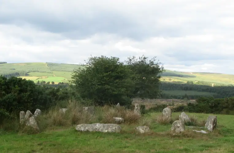
This monument, on a hilltop with an extensive outlook in all directions, is known as Beltany Stone Circle. It lies 3.2km NNW of the cemetery of megalithic tombs centred on Kilmonaster Middle townland.
Full archaeological record 292 words
This monument, on a hilltop with an extensive outlook in all directions, is known as Beltany Stone Circle. It lies 3.2km NNW of the cemetery of megalithic tombs centred on Kilmonaster Middle townland. It consists of a disturbed artificial platform now c. 0.5m high, perhaps the base of a cairn, bounded by a circle of large stones. The circle is c. 45m in diameter. At present 64 stones stand in the circle, and there may originally have been up to 80. Some large stones are exposed in the disturbed interior. It has been suggested that there may have been a megalithic chamber within the circle (O.D. 1939), perhaps a passage tomb (Ó Nualláin 1995, 15).
The earliest accounts of the site seem to be those in the unpublished documentation of the Ordnance Survey dating to the years shortly before the mid-19th century. It is clear that the monument was considerably disturbed at this stage. According to the OS Memoir (1836), there had been a cairn or 'vast heap of stones' within the circle, but it had been removed to form fences in the vicinity. Thomas Fagan (1845-8), who saw the monument in 1846, observed that both the interior and the enclosing circle of stones were much disfigured. He was informed that 'the interior was raised with earth and stones covering and encircling sepulchral graves' and that decayed bones were unearthed here. Excavation would be required to determine whether the enclosed platform is the base of a cairn and whether there was any form of megalithic chamber here.OS Mem oirs, Raphoe parish (1836), 1, 27; Fagan 1845-8, book 10, 28; H. Morris 1939 (Beltany); O.D. 1939 (Beltany); Lacy 1983, 72-3, no. 329 (fig.); SMR 1987, 70:26B; Ó Nualláin 1995, 15; RMP 1995, 70:26/1.
References
- The Beltany Stone Circle (National Monument Number No. 463), consists of a disturbed artificial platform c. 0.5m high defined by a circle of large stones of which sixty-four remain but which originally may have numbered about eighty (Boyle-Somerville 1922-3, 212). The stones are of varying sizes and one of them on the NE is covered on the internal side with cupmarks (there is possibly one cupmark on the external side also). The interior of the site was considerably interfered with in the 1930's (Davies 1939b, 293). Great numbers of loose stones are now lying up against the perimeter megaliths and dotted about the surface of the interior. Several stones protrude from the surface of the interior and in the SW sector there is a standing stone 1m high, almost an equilateral triangle in plan, each side .6m. Partially exposed in the ground to the W of the standing stone is the top of a long stone, possibly that referred to by Davies as suggesting a megalithic chamber. To the SE of the circle is an out-lying standing stone (DG070-026002-) 2m high. Boyle-Somerville suggested that this outlier as well as other features of the adjacent horizon were employed by the circle builders to determine astronomical alignments. The circle is situated on the summit of Beltany Hill in good land with excellent views. Sixty metres to the SW of the stone circle and on a slight terrace just below the summit of the hill, is a circular area (DG070-025----) 35m in diameter, open on the W side but defined elsewhere by stone-wall field boundaries. The area is marked as a 'Graveyard' on the 1st edition of the OS 6-inch maps and as an 'Old Graveyard' on the 2nd edition. It is not clear what the exact nature of this site was but its proximity to the stone circle might suggest that they were in some way related.
Archaeological Survey of Ireland, National Monuments Service (CC BY 4.0) · Compiled by Eamon Cody (Dublin: Stationery Office, 2002) · Updated 22 September 2008. It describes the site as it was when surveyed.
Visitors' notes
Badges are opinions of visitors - not verified facts. One vote per badge and visitor; no account needed.
Best time to visit
What's missing on this page?
Share a tip to find it
Share a local tradition or story
Suggest a correction
Suggest the right map location
Report a duplicate page
Ask a question
Do not include personal data. See our privacy notice.
Around Beltany stone circle
Other heritage nearby
- Raphoe CastleCastle · 2.5 km
- Raphoe Round TowerRound tower · 2.5 km
Recorded within 5 km
- 46 standing stonesArchaeological Survey of Ireland
- 14 ringfortsArchaeological Survey of Ireland
- 13 megalithic tombsArchaeological Survey of Ireland
- 1 ancient churchArchaeological Survey of Ireland
- 1 castleArchaeological Survey of Ireland
- 1 round towerArchaeological Survey of Ireland
- 1 holy wellArchaeological Survey of Ireland
Walks and trails
- Drumboe - Loop trailWalking Trail · 1.0 km · nearest point 12 km
- Riverside Walk & Drumboe TrailWalking Trail · 3.1 km · nearest point 12 km
- Drumboe - Nature trailWalking Trail · 1.2 km · nearest point 12 km
Outdoors, towns and places to stay
- DrumboeForests · 13 km
- LiffordWalled towns · 8.3 km
What's on nearby
- Romeo & Juliet, Ballet Ireland2026-12-01 · 14 km