


Unofficial guide. Not the National Monuments Service, the OPW, Fáilte Ireland or the landowner. Disclaimer
At a glance
- TypePromontory fort - inland
- Date or period mentioned19th century
- StatusNational Monument
What to look for
- Bank and ditch
- Entrance gap
Picked out from the Archaeological Survey description below.
Can you visit?
- No source says it is open to the public.Most monuments in Ireland stand on private farmland.
- Ask the landowner before crossing fields, close gates, leave the stones as you find them.Visiting responsibly
History and description
National Monument No. 184. Caherconree/Cathair Chonraoi is an inland promontory fort located on a mountain spur at the extreme W end of the Slieve Mish mountains, at a height of c. 2050 feet/625m OD.
Full archaeological record 528 words
National Monument No. 184. Caherconree/Cathair Chonraoi is an inland promontory fort located on a mountain spur at the extreme W end of the Slieve Mish mountains, at a height of c. 2050 feet/625m OD. The roughly triangular spur, at the W end of a small plateau, is naturally defended along its NW and SW sides by steep cliffs, and along the more vulnerable E side by a stone wall, 110m long. The area enclosed is about 2 acres in extent, being a maximum of 135m long ENE-WSW and 110m wide SSE-NNW. On a clear day the sweeping view from the site extends to Loop Head in the N, the Blasket islands in the W, and Macgillycuddy's Reeks and the mountains on the Cork/Kerry border in the S and E. The view to NE is blocked by the rising slopes of Caherconree mountain.
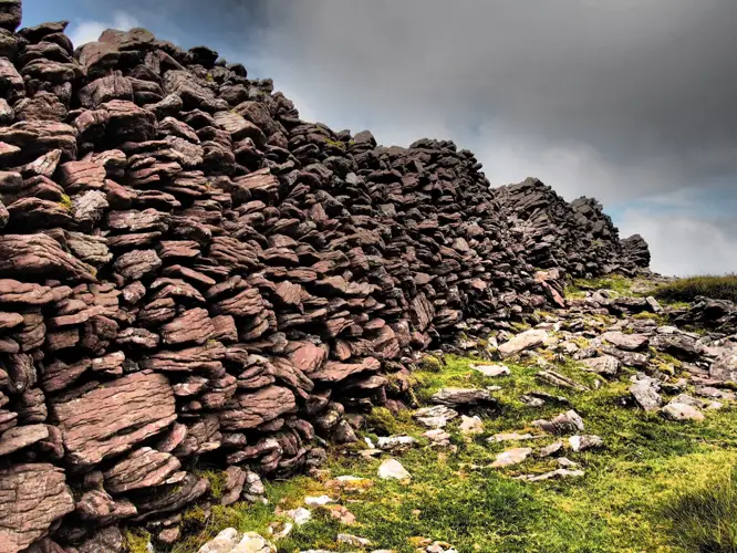
The drystone-built wall stands to a maximum height of 3m, is c. 4.5m thick, and, where best preserved, the inner face rises in 3 steps to the top. Two simple, drystone-faced entrance gaps give access to the interior. The wall spans the full width of the promontory, then curves SW and extends along the SW edge of the promontory for at least 50 to 60m. For the most part, this latter section is completely collapsed, but low sections of the outer face remain standing at a few points. A low bank, up to .75m high and c. 3m wide, and an external fosse, 1.5m wide and .5m deep, occur c. 8 to 10m outside the N section of the wall. The stony nature of the bank suggests that it is either the remains of a stone wall or of a stone-faced bank. Lynch (1899, 12-7) noted that the bank extended the full width of the promontory. The main wall forms part of the boundary between the baronies of Corkaguiney and Trughanacmy, and the boundary line is continued S, for a short distance beyond the end of the main wall, by a low narrow wall of more recent construction.
Four or 5 sub-rectangular or D-shaped structures abut the inner face of the wall. These survive as depressions lined by collapsed walling, and the largest measures 2.25m x 1.6m internally x 1.2m in depth. Another D-shaped foundation abuts the outside of the wall, a little N of the S entrance. It measures 2m x 2.75m internally and its wall is up to .4m high. Another large D-shaped depression in the external collapse, to S of the same entrance, may be a relatively recent sheep-shelter.
A stone trough, apparently removed from the site in the early 19th century, is now located in a house near Killorglin. The rectangular stone measures about 1.3m x 1m x .32m thick, and the rectangular sinking measures 1m x .65m x .18m deep (Lynch 1910, 357-60).
Caherconree derives its name from its legendary builder, Cú Raoi Mac Daire. Legend tells how Cú Raoi defeated and degraded Cúchulainn by a gross insult, carrying off the lady Blathnad. This lady then aided Cúchulainn to defeat and kill Cú Raoi by pouring milk into a stream, which turned it white, as a sign that he should attack.
Archaeological Survey of Ireland, National Monuments Service (CC BY 4.0) · Updated 4 August 2013 · Based on the J. Cuppage, ‘Corca Dhuibhne. Dingle Peninsula archaeological survey. Ballyferriter. Oidhreacht Chorca Dhuibhne. It describes the site as it was when surveyed.
Folklore and traditions
Caherconree derives its name from its legendary builder, Cú Raoi Mac Daire.
Legend tells how Cú Raoi defeated and degraded Cúchulainn by a gross insult, carrying off the lady Blathnad.
Visitors' notes
Badges are opinions of visitors - not verified facts. One vote per badge and visitor; no account needed.
Best time to visit
What's missing on this page?
Share a tip to find it
Share a local tradition or story
Suggest a correction
Suggest the right map location
Report a duplicate page
Ask a question
Do not include personal data. See our privacy notice.
Around Caherconree Promontory Fort
Other heritage nearby
- Killelton ChurchAncient church · 3.5 km
- Ballyduff RingfortRingfort · 5.5 km
- Keel Burial Ground and ChurchAncient church · 6.7 km
- Keel ChurchAncient church · 9.0 km
- Annagh ChurchAncient church · 9.3 km
Recorded within 5 km
- 32 ringfortsArchaeological Survey of Ireland
- 8 standing stonesArchaeological Survey of Ireland
- 3 megalithic tombsArchaeological Survey of Ireland
- 2 castlesArchaeological Survey of Ireland
- 2 ancient churchesArchaeological Survey of Ireland
- 1 ogham stoneArchaeological Survey of Ireland
- 1 promontory fortArchaeological Survey of Ireland
- 1 holy wellArchaeological Survey of Ireland
Walks and trails
- Keel Uphill Downhill Loop WalkWalking Trail · 12.0 km · nearest point 5.5 km
- Caher Marsh LoopWalking Trail · 4.0 km · nearest point 6.2 km
- Ballykissane Centenary Loop WalkWalking Trail · 6.6 km · nearest point 8.7 km
Outdoors, towns and places to stay
- GlanteenassigForests · 11 km
- KillaclohaneForests · 13 km
- DerrymoreBeaches · 4.5 km
- FenitBeaches · 8.7 km · Excellent Quality (2025)
- Derrymore Island Nature ReserveNature reserves · 6.8 km
- Tralee Bay Nature ReserveNature reserves · 7.7 km
- TraleeWalled towns · 13 km
Other attractions nearby
- Derrymore BeachBeach · 4.5 km
- Camp BeachBeach · 5.1 km
- Tralee Bay ExperienceNature and Wildlife · 8.2 km
- Fenit MarinaBeach · 8.2 km
What's on nearby
- National Circus Festival of Ireland2026-11-05 · 13 km
- National Circus Festival of Ireland2026-11-06 · 13 km
- Ralph McTell ‘Somewhere Down the Road’2026-11-06 · 13 km