
Unofficial guide. Not the National Monuments Service, the OPW, Fáilte Ireland or the landowner. Disclaimer
At a glance
- TypeOgham stone
- Recorded sizeH 3.3m; 0.36m x 0.3m
What to look for
- Ogham inscription
- Cross carved
Picked out from the Archaeological Survey description below.
Can you visit?
- No source says it is open to the public.Most monuments in Ireland stand on private farmland.
- Ask the landowner before crossing fields, close gates, leave the stones as you find them.Visiting responsibly
History and description
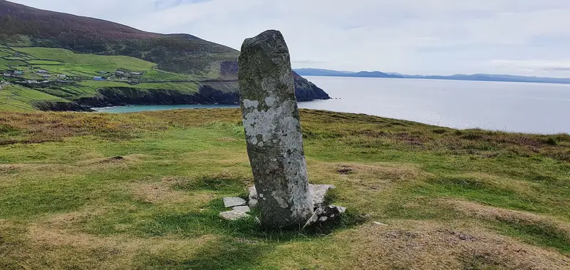
A tall needle-like pillar (H 3.3m; 0.36m x 0.3m) in the N half of a graveyard (CO122-075003-) in an early ecclesiastical enclosure (CO122-075001-). Packing stones are exposed around the denuded base.
Full archaeological record 77 words
A tall needle-like pillar (H 3.3m; 0.36m x 0.3m) in the N half of a graveyard (CO122-075003-) in an early ecclesiastical enclosure (CO122-075001-). Packing stones are exposed around the denuded base. There is a faint outline of a small incised cross with expanded terminals on the W face. The weathered ogham inscription is on the NW corner and was read by Macalister (1945, 79, no. 76) as 'ANM TENAS MACI V'. (Power et al. 1992, no. 1041)
References
- Image provided by and copyright of Amanda Clarke 2016-2022 https://holywellscorkandkerry.com/
Archaeological Survey of Ireland, National Monuments Service (CC BY 4.0) · Compiled by Nora White · Updated 23 April 2016. It describes the site as it was when surveyed.
Visitors' notes
Badges are opinions of visitors - not verified facts. One vote per badge and visitor; no account needed.
Best time to visit
What's missing on this page?
Share a tip to find it
Share a local tradition or story
Suggest a correction
Suggest the right map location
Report a duplicate page
Ask a question
Do not include personal data. See our privacy notice.
Around Templebryan North Ogham Stone
Other heritage nearby
- TobermaryHoly well · 7.6 km
- Timoleague FriaryAbbey or friary · 8.4 km
Recorded within 5 km
- 65 ringfortsArchaeological Survey of Ireland
- 13 standing stonesArchaeological Survey of Ireland
- 11 ancient churchesArchaeological Survey of Ireland
- 3 holy wellsArchaeological Survey of Ireland
- 3 castlesArchaeological Survey of Ireland
- 3 ogham stonesArchaeological Survey of Ireland
- 2 stone circlesArchaeological Survey of Ireland
- 1 monastic siteArchaeological Survey of Ireland
Walks and trails
- Inchybridge LoopWalking Trail · 11.6 km · nearest point 5.5 km
- Grange LoopWalking Trail · 19.2 km · nearest point 8.0 km
- Estuary WalkWalking Trail · 3.9 km · nearest point 8.4 km
Outdoors, towns and places to stay
- CastlefrekeForests · 10 km
- CarrigfaddaForests · 14 km
- Inchydoney East BeachBeaches · 5.6 km · Excellent Quality (2025)
- Inchydoney West BeachBeaches · 5.7 km · Excellent Quality (2025)
- RosscarberyWalled towns · 13 km
- Galley Head Lightkeeper's House 2Historic stays · 14 km
- Galley Head Lightkeeper's House 1Historic stays · 14 km
Other attractions nearby
- Jungle CityAttraction · 2.8 km
- Michael Collins CentreMuseums and Attraction · 4.4 km
- Inchydoney East BeachWalking · 5.5 km
- Inchydoney West BeachWalking · 5.5 km