
Unofficial guide. Not the National Monuments Service, the OPW, Fáilte Ireland or the landowner. Disclaimer
At a glance
- TypeOgham stone
- StatusNational Monument
What to look for
- Ogham inscription
Picked out from the Archaeological Survey description below.
Can you visit?
- No source says it is open to the public.Most monuments in Ireland stand on private farmland.
- Ask the landowner before crossing fields, close gates, leave the stones as you find them.Visiting responsibly
History and description
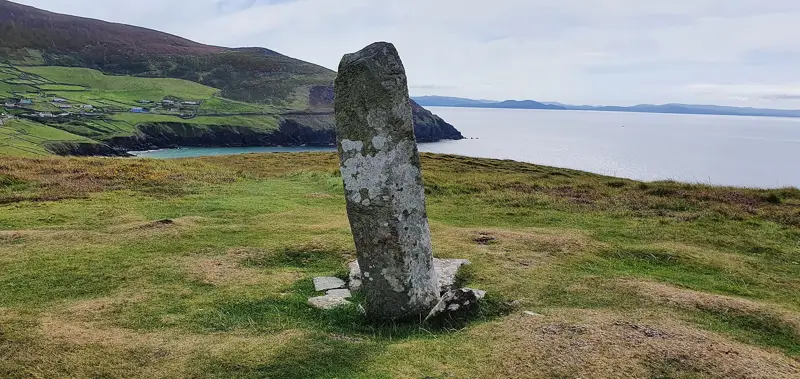
Discovered in 1906 when landowner 'was lowering a headland' (Buckley 1907,116), c. 40m N of, and in next field to, existing ogham stone (CO042-049002-). Macalister (1945, 62, no. 58) gave inscription as CATTUBUTTAS MAQ[...; the scores of the second word terminate at a broken end (see drawing Macalister, ibid.).
Full archaeological record 227 words
Discovered in 1906 when landowner 'was lowering a headland' (Buckley 1907,116), c. 40m N of, and in next field to, existing ogham stone (CO042-049002-). Macalister (1945, 62, no. 58) gave inscription as CATTUBUTTAS MAQ[...; the scores of the second word terminate at a broken end (see drawing Macalister, ibid.). According to White (1905-18, vol. 1, 327), in same field 'about 200 yards to the south, in a gap, is a quantity of broken stones, some of which have some traces of Ogham marks', which now appear to have disappeared; White (ibid.) also noted that 'according to local belief, Ogham stones are buried in the vicinity of Greenhill'. The stone (1.54m 0.46m 0.36m, measurements taken from 3d data) lies against field fence, protected by semicircular cattle grid; when this was laid down in 1985, short excavation by OPW revealed a recent shallow trench cut into much larger ditch possibly belonging to an ancient enclosure (pers. comm. C. Manning); marked curve in field fence here might respect line of ancient enclosure of which there is no other visible surface trace. Burnfort ogham stone (CO042-052003-) found c. 900m to SE. (Power et al. 1997, no. 7964)
This stone has been studied as part of the ‘Ogham in 3D’ project undertaken by the School of Celtic Studies, Dublin Institute for Advanced Studies. To access details go to the following website: http://ogham.celt.dias.ie/search.php?ciic=58
Archaeological Survey of Ireland, National Monuments Service (CC BY 4.0) · Compiled by Paul Walsh · Updated 31 December 2014. It describes the site as it was when surveyed.
Folklore and traditions
According to White (1905-18, vol. 1, 327), in same field 'about 200 yards to the south, in a gap, is a quantity of broken stones, some of which have some traces of Ogham marks', which now appear to have disappeared; White (ibid.) also noted that 'according to local belief, Ogham stones are buried in the vicinity of Greenhill'.
Visitors' notes
Badges are opinions of visitors - not verified facts. One vote per badge and visitor; no account needed.
Best time to visit
What's missing on this page?
Share a tip to find it
Share a local tradition or story
Suggest a correction
Suggest the right map location
Report a duplicate page
Ask a question
Do not include personal data. See our privacy notice.
Around Greenhill Ogham Stones
Other heritage nearby
- Mourne AbbeyAbbey or friary · 1.4 km
- Aunia's WellHoly well · 6.1 km
- Mallow CastleCastle · 6.6 km
- Lady's WellHoly well · 7.0 km
Recorded within 5 km
- 40 ringfortsArchaeological Survey of Ireland
- 13 standing stonesArchaeological Survey of Ireland
- 5 ancient churchesArchaeological Survey of Ireland
- 4 holy wellsArchaeological Survey of Ireland
- 2 ogham stonesArchaeological Survey of Ireland
- 2 megalithic tombsArchaeological Survey of Ireland
- 2 castlesArchaeological Survey of Ireland
- 1 abbey or friaryArchaeological Survey of Ireland
- 1 stone circleArchaeological Survey of Ireland
Walks and trails
- Lovers LeapWalking Trail · 0.5 km · nearest point 6.3 km
- Killavullen LoopWalking Trail · 11.9 km · nearest point 7.8 km
- Blackwater Way - AvondhuLong Distance Waymarked Way · 126.3 km · nearest point 7.9 km
Outdoors, towns and places to stay
- ArdarouForests · 13 km
- Kilcolman Bog Nature ReserveNature reserves · 19 km
- Kilcolman Bog Nature ReserveNature reserves · 19 km
- Mourne/MoraWalled towns · 2.3 km
- MallowWalled towns · 6.7 km
- Annes Grove Miniature CastleHistoric stays · 16 km
- GlenlohaneHistoric stays · 18 km
Other attractions nearby
- Mallow CastleHistoric Houses and Castle · 6.6 km
- Nano Nagle BirthplaceMuseums and Attraction · 10.0 km