
Unofficial guide. Not the National Monuments Service, the OPW, Fáilte Ireland or the landowner. Disclaimer
At a glance
- TypeOgham stone
What to look for
- Ogham inscription
Picked out from the Archaeological Survey description below.
Can you visit?
- No source says it is open to the public.Most monuments in Ireland stand on private farmland.
- Ask the landowner before crossing fields, close gates, leave the stones as you find them.Visiting responsibly
History and description
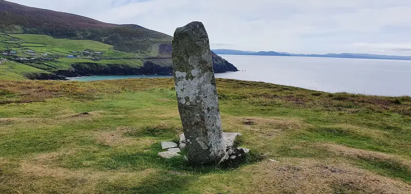
A souterrain (WA024-033004-) associated with the perimeter of an ecclesiastical enclosure (WA024-033003-) at the N contained ten ogham stones which are now preserved at the site. This is the fourth lining stone on the W side (recorded as an 'unshapely mass of greenstone', 0.97m x 0.66m x 0.09m converted from Macalister 1945) and is still in situ.
Full archaeological record 109 words
A souterrain (WA024-033004-) associated with the perimeter of an ecclesiastical enclosure (WA024-033003-) at the N contained ten ogham stones which are now preserved at the site. This is the fourth lining stone on the W side (recorded as an 'unshapely mass of greenstone', 0.97m x 0.66m x 0.09m converted from Macalister 1945) and is still in situ. Macalister (1945, 276, no. 281) read the ogham inscription (a palimpsest) as: DEAGOS MAQI MUCO[I……]NAI. (Moore 1999, 1487)
This stone has been studied as part of the ‘Ogham in 3D’ project undertaken by the School of Celtic Studies, Dublin Institute for Advanced Studies. To access details go to the following website: https://ogham.celt.dias.ie/search.php?ciic=281
References
- This monument is subject to a preservation order made under the National Monuments Acts 1930 to 2014 (PO no. 12/1933).
Archaeological Survey of Ireland, National Monuments Service (CC BY 4.0) · Compiled by Nora White · Updated 27 July 2016. It describes the site as it was when surveyed.
More ogham stones nearby

Visitors' notes
Badges are opinions of visitors - not verified facts. One vote per badge and visitor; no account needed.
Best time to visit
What's missing on this page?
Share a tip to find it
Share a local tradition or story
Suggest a correction
Suggest the right map location
Report a duplicate page
Ask a question
Do not include personal data. See our privacy notice.
Around Drumlohan Ogham Stone
Other heritage nearby
- Kilrossanty WellsHoly well · 5.5 km
- Boolattin RingfortRingfort · 5.9 km
Recorded within 5 km
- 45 ringfortsArchaeological Survey of Ireland
- 14 ogham stonesArchaeological Survey of Ireland
- 12 standing stonesArchaeological Survey of Ireland
- 6 ancient churchesArchaeological Survey of Ireland
- 5 castlesArchaeological Survey of Ireland
- 2 monastic sitesArchaeological Survey of Ireland
- 2 holy wellsArchaeological Survey of Ireland
- 2 promontory fortsArchaeological Survey of Ireland
Walks and trails
- Waterford Greenway Cycling TrailGreenway · 47.9 km · nearest point 2.0 km
- Waterford Greenway Walking TrailGreenway · 47.9 km · nearest point 2.0 km
- Sean Kelly Cycle Route - The Coastal RouteRoad Cycling Trail · 75.1 km · nearest point 3.3 km
Outdoors, towns and places to stay
- KilclooneyForests · 9.2 km
- BallyvooneyBeaches · 4.3 km
- StradballyBeaches · 4.5 km
- Fenor Bog Nature ReserveNature reserves · 16 km
- DungarvanWalled towns · 13 km
Other attractions nearby
- Stradbally Medieval ChurchAbbeys and Monastery · 3.7 km
- The Greenway Man - Cycling Tours and Bike HireNature and Wildlife · 4.7 km
- StepsBackThruTime Guided Walking Tour ExperiencesWalking · 5.6 km
- Mayfield Birds of Prey FalconryNature and Wildlife · 5.8 km
What's on nearby
- A ROOTS Conversation with David Skinner2026-11-15 · 19 km
- Christmas Wreath-Making Workshop at Mount Congreve Gardens2026-12-05 · 19 km
- Christmas Bauble Painting Workshop at Mount Congreve Gardens2026-12-06 · 19 km