
Unofficial guide. Not the National Monuments Service, the OPW, Fáilte Ireland or the landowner. Disclaimer
At a glance
- TypeHillfort
- Date or period mentionedearly medieval
- Condition (as surveyed)Survives well
- StatusNational Monument
What to look for
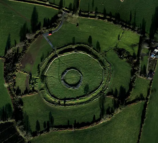
- Bank and ditch
- Entrance gap
Picked out from the Archaeological Survey description below.
Visiting
- National Monument in State care, listed by the National Monuments Service as a monument to visit.NMS Monuments to Visit · official page
- May be on private land and not open to the publicNational Monuments Service advice
- Wear suitable footwear and clothingNational Monuments Service advice
- Uneven ground: not suitable for everyone, especially wheelchair usersNational Monuments Service advice
Opening times and fees change: check with the operator before you go.
About The 'Grianán of Aileach'
- NeolithicThere is also a small stone cairn nearby that is most likely a burial monument from the…
- 1000BCThe monument clearly has ancient origins and surrounding the stone fort are the remains…
- 9th centuryThe stone fort is believed to have been constructed during the 8th or 9th century as the…
Where it is
- On the summit of Greenan Mountain is the stone fort known as the Grianán of Aileach.
Its history
- The stone fort is believed to have been constructed during the 8th or 9th century as the seat of Cenél nEógain, rulers of the ancient kingdom of Aileach.
- The monument clearly has ancient origins and surrounding the stone fort are the remains of a much older hillfort that was most likely constructed around 1000BC.
- There is also a small stone cairn nearby that is most likely a burial monument from the Neolithic or Early Bronze Age.
What you'll see
- From the site there are spectacular views over Lough Foyle, Lough Swilly and the surrounding countryside.
- The interior of the circular fort measures some 23m across and an entrance passage extends through the thickness of the massive encircling wall.
- This dry-stone wall stands some 5m high and incorporates a series of terraces that are accessed by stone steps.
Text: National Monuments Service, Monuments to Visit (CC BY 4.0). Sentences grouped by topic by ErinSites; the wording is unchanged.
History and description
Full archaeological record 472 words
Located in rough terrain on the summit of a hill looking N across the former marshy area which separates Inishowen from the rest of Donegal. It commands extensive views along Lough Swilly and Lough Foyle and much of the surrounding area in Counties Derry, Donegal and Tyrone.
The site known as the 'Grianán of Aileach' (National Monument number 140) consists of a restored cashel (DG047-012001-) centrally placed within a series of three enclosing earthen banks (DG047-012005-), a cairn (DG047-012002-), an approaching routeway or 'ancient road' (DG047-012004-) and a holy well (DG047-012003-).
The three outer enclosing banks of the cashel may represent the remains of a hillfort which predated the cashel. The innermost external bank is at a distance of c. 25m from the cashel wall. It is very low, worn and heather-covered but traceable for almost its entire circuit. A gap to the ENE gave onto the 'ancient road' (DG047-012004-) which approached the summit of the hill between two natural ledges of rock outcrop. Petrie's plan of the site shows the distance between this gap and the cashel entrance lined by settings of stones (Colby 1837, 217-232). There are possible indications of a fosse on the external side of the bank. The middle and outer banks exploit the contours of the top of the hill at varying distances from each other and from the cashel. The middle bank encloses an area of 4 acres (1.6 hectares). Like the inner bank, the middle and outer banks are much worn away and heather-covered. For long stretches they are untraceable, particularly the outer bank. There are slight indications, in places, of a fosse on the internal side of the middle bank and possibly indications of another fosse in places between the two banks, but turf-cutting and general erosion make it difficult to be certain. While some stone is visible in the banks they are predominantly of earthen construction.
A cairn (DG047-012002-) is located midway between the inner and middle banks to SE of the cashel entrance, and there is a holy well (DG047-012003-) between the two outer banks on the S side of the hill.
It is likely that this is a multi-period site. The cairn (DG047-012002-) may have been dated to the Neolithic period or the Bronze Age. The earthen enclosures are usually interpreted as a hillfort of the Late Bronze Age or Iron Age (Raftery 1972, 37-58). The cashel (G047-012001-) dates to the early medieval period. Although a site in the nearby townland of Elaghmore (now inside the boundary of County Derry) is sometimes put forward as the site of Aileach, the ancient seat of the northern Ui Neill, most writers have identified the monuments described above as the location of that important settlement. There is much legendary and historical material associated with Aileach and the Irish annals record its destruction in 1101.
Archaeological Survey of Ireland, National Monuments Service (CC BY 4.0) · Compiled by Brian Lacey with Eamon Cody, Claire Cotter, Judy Cuppage, Noel Dunne, Vincent Hurley, Celie O'Rahilly, Paul Walsh and Seán Ó Nualláin (Lifford: Donegal County Council, 1983). In certain instances the entries have been revised and updated · Updated 22 September 2008. It describes the site as it was when surveyed.
Folklore and traditions
There is much legendary and historical material associated with Aileach and the Irish annals record its destruction in 1101.
Visitors' notes
Badges are opinions of visitors - not verified facts. One vote per badge and visitor; no account needed.
Best time to visit
What's missing on this page?
Share a tip to find it
Share a local tradition or story
Suggest a correction
Suggest the right map location
Report a duplicate page
Ask a question
Do not include personal data. See our privacy notice.
Around The 'Grianán of Aileach'
Other heritage nearby
- Grianan of AileachRingfort · 0.0 km
- Burt CastleCastle · 4.8 km
- Inch CastleCastle · 5.1 km
Recorded within 5 km
- 10 ringfortsArchaeological Survey of Ireland
- 5 standing stonesArchaeological Survey of Ireland
- 3 castlesArchaeological Survey of Ireland
- 2 holy wellsArchaeological Survey of Ireland
- 1 megalithic tombArchaeological Survey of Ireland
Walks and trails
- Inis Eoghain CyclewayRoad Cycling Trail · 58.0 km · nearest point 1.1 km
- Maylin WoodWalking Trail · 0.8 km · nearest point 10.0 km
- Grania’s Gap LoopWalking Trail · 7.0 km · nearest point 10 km
Outdoors, towns and places to stay
- LisfannonBeaches · 8.9 km · Good Quality (2025)
- RathmullanBeaches · 10 km · Good Quality (2025)
- Rathmullen Wood Nature ReserveNature reserves · 11 km
- Ballyarr Wood Nature ReserveNature reserves · 18 km
- LondonderryWalled towns · 7.4 km
Other attractions nearby
- Inch Wildfowl ReserveNatural Landscape · 3.3 km
- Inch IslandHistoric Houses and Castle · 6.1 km
- Lenamore StablesNature and Wildlife · 7.1 km
- Dunmore GardensGardens · 7.7 km
What's on nearby
- Wild Arctic Experience at Wild Ireland2026-11-20 · 6.5 km
- Wild Arctic Experience at Wild Ireland2026-11-21 · 6.5 km
- Wild Arctic Experience at Wild Ireland2026-11-22 · 6.5 km