


Unofficial guide. Not the National Monuments Service, the OPW, Fáilte Ireland or the landowner. Disclaimer
At a glance
- TypeHillfort
- Date or period mentioned10th century
- StatusNational Monument
What to look for
- Bank and ditch
- Entrance gap
- Ramparts
Picked out from the Archaeological Survey description below.
Can you visit?
- No source says it is open to the public.Most monuments in Ireland stand on private farmland.
- Ask the landowner before crossing fields, close gates, leave the stones as you find them.Visiting responsibly
History and description
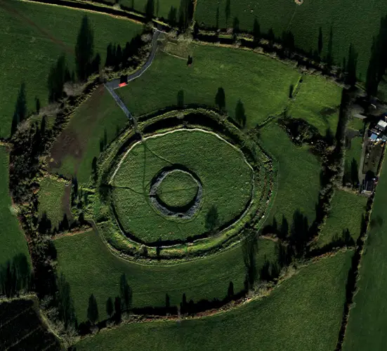
A trivallate hillfort, occupying the entire summit of a prominent limestone hill, c. 2.5km NE of Newmarket-on-Fergus, with commanding views over SE Clare, the Shannon Estuary to the S and the river Fergus to the W. It has three roughly concentric ramparts comprising massive walls of uncoursed stone. The outer rampart encloses an area of about 11 hectares and the ramparts have a total length of 2.1km.
Full archaeological record 620 words
A trivallate hillfort, occupying the entire summit of a prominent limestone hill, c. 2.5km NE of Newmarket-on-Fergus, with commanding views over SE Clare, the Shannon Estuary to the S and the river Fergus to the W. It has three roughly concentric ramparts comprising massive walls of uncoursed stone. The outer rampart encloses an area of about 11 hectares and the ramparts have a total length of 2.1km. Each rampart is set along the outer edge of a natural step in the limestone thereby enhancing the apparent height. It is believed that the ramparts were built as a single enterprise over a period of about a decade and the radiocarbon evidence as a whole suggests that this would have occurred in the final two decades of the tenth century BC. Survey and excavation (licence no. 92E0093) by the Discovery Programme, as part of the North Munster Project, took place in 1992-4.
The inner rampart (av. H 1.5m; Wth 6-9m) encloses an area of 0.75 hectares (diam. 110m E-W; 90m N-S). Variations in slope and topography account for some differences in construction and the building of a later cashel (CL042-074002-) on top of the middle rampart caused considerable destruction at SW. While Westropp (1908-9) indicated three gaps in this rampart, these represent modern access points. A previously unrecorded gap (av. Wth 0.9m) at SE faced with slabs and upright blocks was identified during pre-excavation clearance. The track leading to this had to meander around the hill following a circuit between the staggered entrances through the three ramparts.
The middle rampart (Wth 8-11m; ext. H up to 3.5m) encloses an area of 2.88 hectares (192m E-W; 191m N-S). At SW the rampart is 6m in external height and only 0.5m high internally. Of the four gaps in the middle rampart only the one at N (Wth 2.4m) appears to be original. It was slab-faced and ran straight through the main, inner, portion of the rampart but angled sharply to the W through the outer portion. There is a small rectangular intramural chamber (2.8m x 1.4m; D 1.6m) in the NW quadrant of this rampart of unknown purpose. A length of wall (80m) extends along the NW quadrant c. 3m inside the middle rampart and appears to be an original feature. As mentioned above, a cashel (CL042-074002-) was built on top of this rampart at SW.
The outer rampart is composed of a large inner bank of stones with a smaller outer bank and an intervening fosse. The scale of these three components alters in accordance with changes in the hill slope and topography. Several entrances have been noted and mapped but only one (Wth 2m) at SW is considered to be original. The terminals of the banks are very well defined at this location and the undug causeway across the fosse is flanked by the incurving horns of both banks.
The inner rampart probably enclosed the area within which special gatherings and ceremonies took place, possibly centred on the cairn (CL042-074013-). Radiocarbon evidence as a whole suggests that the ramparts were built as a single enterprise over about a period of a decade towards the end of the 10th century BC.
A number of monuments occur within the hillfort. A cairn (CL042-074013-) occupies the highest point in the interior. A cashel (CL042-074004-) on the outer rampart at NW is on the site of an earlier enclosure (CL042-073003-) and there is a cashel (CL042-074002-) on the middle rampart at SW. There are three other enclosures outside the middle rampart at NW (CL042-074008-, CL042-074009-, and CL042-074010-) and three unenclosed round houses (CL042-074014-, CL042-074015-, CL042-074016-) between the inner and middle ramparts at SW. Mooghaun hillfort is a National Monument in state care, no. 649. (Grogan 2005)
Archaeological Survey of Ireland, National Monuments Service (CC BY 4.0) · Compiled by Mary Tunney · Updated 5 January 2016. It describes the site as it was when surveyed.
Also recorded nearby
Named sites within 5 km with only a short entry in the Archaeological Survey.
- Ballyhannon CastleCastle - tower house · Castlefergus · 2.9 km · official record
- Kilnasoolagh ChurchChurch · Kilnasoolagh · 3.2 km · official record
- Knappogue CastleCastle - tower house · Knopoge · 3.4 km · official record
Visitors' notes
Badges are opinions of visitors - not verified facts. One vote per badge and visitor; no account needed.
Best time to visit
What's missing on this page?
Share a tip to find it
Share a local tradition or story
Suggest a correction
Suggest the right map location
Report a duplicate page
Ask a question
Do not include personal data. See our privacy notice.
Around Mooghaun
Other heritage nearby
- Quin AbbeyAbbey or friary · 4.2 km
- Quin AbbeyCastle · 4.2 km
- ToberinneenboyHoly well · 4.3 km
- Craggaunowen - The Living Past ExperienceCastle · 6.5 km
- Clare AbbeyAbbey or friary · 8.0 km
- Killone AbbeyAbbey or friary · 8.9 km
Recorded within 5 km
- 68 ringfortsArchaeological Survey of Ireland
- 19 castlesArchaeological Survey of Ireland
- 12 standing stonesArchaeological Survey of Ireland
- 8 holy wellsArchaeological Survey of Ireland
- 5 megalithic tombsArchaeological Survey of Ireland
- 4 ancient churchesArchaeological Survey of Ireland
- 1 abbey or friaryArchaeological Survey of Ireland
- 1 monastic siteArchaeological Survey of Ireland
Walks and trails
- Mid Clare Way - Slí na MearacaunLong Distance Waymarked Way · 142.9 km · nearest point 0.2 km
- Kilkishen Bog WalkWalking Trail · 0.9 km · nearest point 8.6 km
- 12 O'Clock Hills Looped Walks - Purple RouteWalking Trail · 11.8 km · nearest point 11 km
Outdoors, towns and places to stay
- Cratloe WoodForests · 12 km
- Ballyallia Lake, EnnisBeaches · 12 km · Excellent Quality (2025)
- Dromore Nature ReserveNature reserves · 17 km
- Newpark HouseHistoric stays · 9.5 km
- Inchiquin HouseHistoric stays · 23 km
Other attractions nearby
- Quin Historical Cycling and Walking ToursWalking · 4.0 km
- Quin AbbeyHistoric Houses and Castle · 4.2 km
- Craggaunowen - The Living Past ExperienceHistoric Houses and Castle · 6.5 km
- Heartlands EcotoursWalking · 7.4 km
What's on nearby
- Traditional Music of Europe2026-11-08 · 9.6 km · free
- Romeo & Juliet, Ballet Ireland2026-11-24 · 9.6 km
Excavations nearby
- 04E0050 Manusmore Site AR150, County ClareRoad-scheme excavation report (TII) · 3.2 km
- 04E0187 Manusmore Site AR100, County ClareRoad-scheme excavation report (TII) · 3.5 km