
Unofficial guide. Not the National Monuments Service, the OPW, Fáilte Ireland or the landowner. Disclaimer
At a glance
- TypeHillfort
What to look for
- Bank and ditch
- Entrance gap
- Hut sites
- Ramparts
Picked out from the Archaeological Survey description below.
Can you visit?
- No source says it is open to the public.Most monuments in Ireland stand on private farmland.
- Ask the landowner before crossing fields, close gates, leave the stones as you find them.Visiting responsibly
History and description
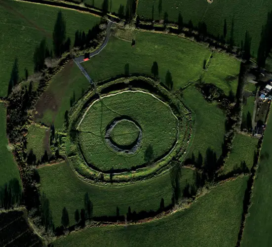
The hillfort was recently described in the Atlas of Hillforts of Britain and Ireland as following; 'Overlooking the Limerick lowlands and with excellent views to the N, E and W, an oval hillslope fort with a total site footprint of approximately 1.3ha is positioned in a highly visible area just off the summit of a hilltop at the N foothills of Slievereagh Mountain.
Full archaeological record 168 words
The hillfort was recently described in the Atlas of Hillforts of Britain and Ireland as following; 'Overlooking the Limerick lowlands and with excellent views to the N, E and W, an oval hillslope fort with a total site footprint of approximately 1.3ha is positioned in a highly visible area just off the summit of a hilltop at the N foothills of Slievereagh Mountain. Univallate for the entire circuit with two simple entrance gaps in the E and W. No internal features recorded, although a number of small, circular features at the centre of the fort are apparent in aerial photography. These may represent hut structures. Ramparts survive well throughout the circuit. The external ditch is apparent in the W and is not visible for the remainder of the circuit. A track-way abutting the external ditch at the W also represents a townland boundary. The interior is under pasture. First map depiction in first edition Ordnance Survey mapping. More detailed earthwork survey in second edition Ordnance Survey mapping.' (http://hillforts.arch.ox.ac.uk/records/IR0916.html)
Archaeological Survey of Ireland, National Monuments Service (CC BY 4.0) · Compiled by Caimin O’Brien · Updated 30 January 2020. It describes the site as it was when surveyed.
Visitors' notes
Badges are opinions of visitors - not verified facts. One vote per badge and visitor; no account needed.
Best time to visit
What's missing on this page?
Share a tip to find it
Share a local tradition or story
Suggest a correction
Suggest the right map location
Report a duplicate page
Ask a question
Do not include personal data. See our privacy notice.
Around Dunglara
Other heritage nearby
- Cush EarthworksRingfort · 3.1 km
- ToberbreediaHoly well · 3.5 km
- Lady's WellHoly well · 3.7 km
- Deborah's WellHoly well · 4.6 km
- Lady's WellHoly well · 5.3 km
- DuntryleagueMegalithic tomb · 5.4 km
Recorded within 5 km
- 31 ringfortsArchaeological Survey of Ireland
- 15 holy wellsArchaeological Survey of Ireland
- 15 standing stonesArchaeological Survey of Ireland
- 8 ancient churchesArchaeological Survey of Ireland
- 6 castlesArchaeological Survey of Ireland
- 2 megalithic tombsArchaeological Survey of Ireland
- 1 ogham stoneArchaeological Survey of Ireland
Walks and trails
- Ballyhoura - Slieve Reagh LoopWalking Trail · 10.5 km · nearest point 1.5 km
- Kilmallock Cycle Hub Loop 2Road Cycling Trail · 141.6 km · nearest point 1.6 km
- Ballyhoura - Kilfinane LoopWalking Trail · 10.6 km · nearest point 2.0 km
Outdoors, towns and places to stay
- BallyhouraForests · 11 km
- EmlyWalled towns · 9.0 km
- KilmallockWalled towns · 12 km
- Annes Grove Miniature CastleHistoric stays · 22 km
Other attractions nearby
- Kilfinane Outdoor Education CentreWalking · 5.9 km
- Moor AbbeyHistoric Houses and Castle · 8.3 km
- St John’s Church KnockaineyHistoric Houses and Castle · 11 km
- Animal Magic – Falconry and ConservationNature and Wildlife · 12 km