
Unofficial guide. Not the National Monuments Service, the OPW, Fáilte Ireland or the landowner. Disclaimer
At a glance
- TypeHillfort
What to look for
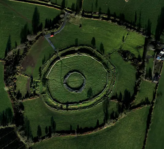
- Bank and ditch
- Entrance gap
Picked out from the Archaeological Survey description below.
Can you visit?
- No source says it is open to the public.Most monuments in Ireland stand on private farmland.
- Ask the landowner before crossing fields, close gates, leave the stones as you find them.Visiting responsibly
History and description
In commanding position surrounding the flat summit of Mount Garret. Circular level terrain fort has panoramic views in all directions, however, the shape of the hill prevents views of the N base of the mountain.
Full archaeological record 204 words
In commanding position surrounding the flat summit of Mount Garret. Circular level terrain fort has panoramic views in all directions, however, the shape of the hill prevents views of the N base of the mountain. The mountain overlooks an E-W running gap in the Slieveardagh Hills http://hillforts.arch.ox.ac.uk/records/IR0676).
The circular hillfort (diam. 205m) encompasses the higher S end of the ridge and has a large cairn, possibly a passage-tomb (KK008-124001-) at its centre. The hillfort is enclosed by a grass-covered stoney bank (Basal Wth 4-5m; Wth at crest 2.5-3m; H c. 0.3-0.5m) which is clearly visible except in the NW quadrant where it is more denuded. In the E-SE quadrant upright facing stones are visible and for a short length low stone slabs survive both internally and externally, indicating that the grass-covered bank was originally a wall (Wth 2.8m). The interior of the hillfort is undulating and the enclosing element does not follow the contours of the hill but largely ignores them in order to maintain circularity (Pers. Comm. Barry Raftery, 7 October 1986). There is no evidence of an entrance. A substantial field boundary runs NE-SW across the northern half of the hillfort, from NE-W. Another field boundary runs NW-SE through the SW quadrant.
Archaeological Survey of Ireland, National Monuments Service (CC BY 4.0) · Compiled by Jean Farrelly · Updated 4 February 2020. It describes the site as it was when surveyed.
Also recorded nearby
Named sites within 5 km with only a short entry in the Archaeological Survey.
- Coolcashin CastleCastle - unclassified · Coolcashin · 4.6 km · official record
Visitors' notes
Badges are opinions of visitors - not verified facts. One vote per badge and visitor; no account needed.
Best time to visit
What's missing on this page?
Share a tip to find it
Share a local tradition or story
Suggest a correction
Suggest the right map location
Report a duplicate page
Ask a question
Do not include personal data. See our privacy notice.
Around Clonmantagh
Other heritage nearby
- Ballycuddihy CastleCastle · 1.6 km
- Donoughmore ChurchAncient church · 2.1 km
- Balief CastleCastle · 2.2 km
- Clomantagh CastleCastle · 2.2 km
- Clomantagh ChurchAncient church · 2.3 km
- Killoshulan CastleCastle · 2.8 km
Recorded within 5 km
- 54 ringfortsArchaeological Survey of Ireland
- 12 castlesArchaeological Survey of Ireland
- 12 ancient churchesArchaeological Survey of Ireland
- 6 holy wellsArchaeological Survey of Ireland
- 2 megalithic tombsArchaeological Survey of Ireland
- 2 monastic sitesArchaeological Survey of Ireland
- 1 abbey or friaryArchaeological Survey of Ireland
- 1 round towerArchaeological Survey of Ireland
Walks and trails
- North Kilkenny Cycle RouteRoad Cycling Trail · 80.5 km · nearest point 3.0 km
- Gathabawn LoopWalking Trail · 11.3 km · nearest point 3.9 km
- Gathabawn Short LoopWalking Trail · 4.1 km · nearest point 3.9 km
Outdoors, towns and places to stay
- CapponellanForests · 12 km
- JenkinstownForests · 15 km
- Coolacurragh Wood Nature ReserveNature reserves · 14 km
- Grantstown Wood and Grantstown Lough Nature ReserveNature reserves · 15 km
- Clomanatagh CastleHistoric stays · 2.2 km
Other attractions nearby
- Kilcooley AbbeyAbbeys and Monastery · 8.8 km
- River NoreNature and Wildlife · 11 km
What's on nearby
- Pa Sheehy The Magic We Found Tour2026-11-05 · 19 km
- Limitless With Mark The Science Guy!2026-11-08 · 19 km · free
- Bad Apples2026-12-02 · 19 km
Excavations nearby
- E2392 Foulkscourt AR 50, County KilkennyRoad-scheme excavation report (TII) · 4.4 km
- E2391 Foulkscourt AR 49, County KilkennyRoad-scheme excavation report (TII) · 4.5 km