
Unofficial guide. Not the National Monuments Service, the OPW, Fáilte Ireland or the landowner. Disclaimer
At a glance
- TypeHillfort
- Date or period mentioned1933
- Recorded sizemax. H 1.6m; average base W 9m
- StatusNational Monument
What to look for
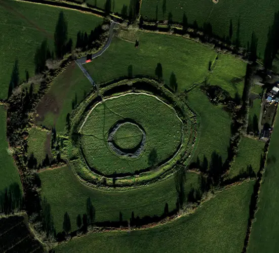
- Bank and ditch
- Entrance gap
- Ramparts
Picked out from the Archaeological Survey description below.
Can you visit?
- No source says it is open to the public.Most monuments in Ireland stand on private farmland.
- Ask the landowner before crossing fields, close gates, leave the stones as you find them.Visiting responsibly
History and description
In commanding position, enclosing Corrin Hill at the E end of the Nagle Mountain range, overlooking the Blackwater and Bride river valleys to the N and S respectively. This heavily overgrown hillfort is defined by a roughly oval area (c. 250m N-S; c. 180m E-W; 2.92ha) narrowing slightly at the S, enclosed by a substantial bank or rampart of dumped rubble construction (max. H 1.6m; average base Wth 9m).
Full archaeological record 519 words
In commanding position, enclosing Corrin Hill at the E end of the Nagle Mountain range, overlooking the Blackwater and Bride river valleys to the N and S respectively. This heavily overgrown hillfort is defined by a roughly oval area (c. 250m N-S; c. 180m E-W; 2.92ha) narrowing slightly at the S, enclosed by a substantial bank or rampart of dumped rubble construction (max. H 1.6m; average base Wth 9m). Forestry comes within c. 20 m of the bank. In the centre of the hillfort is a bronze-age burial cairn (CO035-04902-) which when investigated in 1832 was found to contain two burials, one of which was later identified as a probable food vessel burial (CO035-04903-). Directly to the E of the cairn is a stone cross erected in 1933 to commemorate the 19th centenary of the death of Christ, probably using stones from the cairn (Doody 2008, 548). Carntierna hillfort is one of three sites in North Cork which conforms to Raftery’s definition of a ‘hillfort’ (Power et al. 2000, 205). Ó Murchú (1978, 46-51) noted that in 1949 'the remains of three great embankments were clearly visible'; it was possible to trace the complete circle of the outer 'embankment' with a wide opening to W, 'one end of which curled in while the other end overlapped it on the outside - giving the appearance of a gate-way or entrance'; he noted a 'middle embankment' from SW to NE and an inner embankment only on the NW side for 'several yards'; each separated by fosses, and all subsequently disturbed by forestry.
The site is crossed WNW-ESE by townland and barony boundaries. The bank is quite ruinous in places, and topped with a modern stone wall (L c. 50m) to the E. In the NW quadrant is a sunken passage (Wth 2m), identified as the fort’s entrance (see plan in Doody ibid., 549). The bank curves inward from WNW to N to accommodate earthen outworks of 2 to 3 banks with intervening fosses ‘possibly indicating a greater need for defences/fortification on this more accessible side’ (Doody ibid., 551). To the N of the NW quadrant, another entrance feature was recorded comprised of a passageway (Wth 5m) cutting perpendicularly through the outworks and flanked by two parallel banks (c. 0.2m H). It is offset c. 35m N of the entrance through the main bank (ibid. 554-5). There are three breaks in the main bank, in addition to the entrance. One is located in the WNW where the barony boundary and a trackway come through; the latter runs parallel to and on the S side of the barony boundary and breaks through it on the E side of the cairn to access a stone cross to the N; the barony boundary exits across the bank to the ESE. There are two further breaks in the bank to the SE and to the SSE. There are some traces of an outer bank to the SW and W. The interior slopes steeply down from the cairn on the hilltop and is very disturbed and overgrown.
This is a National Monument in State Care (no. 592).
Archaeological Survey of Ireland, National Monuments Service (CC BY 4.0) · Updated 14 January 2009 · Based on the Archaeological Inventory of County Cork. Volume 4: North Cork. It describes the site as it was when surveyed.
Also recorded nearby
Named sites within 5 km with only a short entry in the Archaeological Survey.
- Lady WellRitual site - holy well · Glenarousk · 2.7 km · official record
In pasture, on steep SSE-facing slope. Spring, rising from within slope; water piped into trough flanked by railway sleepers. No longer in holy use.
Visitors' notes
Badges are opinions of visitors - not verified facts. One vote per badge and visitor; no account needed.
Best time to visit
What's missing on this page?
Share a tip to find it
Share a local tradition or story
Suggest a correction
Suggest the right map location
Report a duplicate page
Ask a question
Do not include personal data. See our privacy notice.
Around Carntierna
Other heritage nearby
- Castlelyons ChurchAncient church · 3.9 km
- Castlelyons FriaryAbbey or friary · 4.4 km
- Fortified House, CastlelyonsCastle · 4.7 km
- Coole Upper Two ChurchesAncient church · 5.4 km
- Coole Upper Holy WellHoly well · 5.5 km
- Labbacallee wedge tombMegalithic tomb · 7.5 km
Recorded within 5 km
- 11 ringfortsArchaeological Survey of Ireland
- 9 ancient churchesArchaeological Survey of Ireland
- 6 holy wellsArchaeological Survey of Ireland
- 6 castlesArchaeological Survey of Ireland
- 2 abbeys & friariesArchaeological Survey of Ireland
- 1 monastic siteArchaeological Survey of Ireland
Walks and trails
- Corrin WoodWalking Trail · 4.3 km · nearest point 0.3 km
- Castleblagh - Woodland TrailWalking Trail · 2.8 km · nearest point 8.1 km
- Moanbaun Wood - Nature trailWalking Trail · 3.5 km · nearest point 12 km
Outdoors, towns and places to stay
- CorrinForests · 0.6 km
- KilbarryForests · 7.6 km
- Ballyvolane HouseHistoric stays · 9.3 km
- Annes Grove Miniature CastleHistoric stays · 16 km
Other attractions nearby
- Castlelyons Dominican FriaryAbbeys and Monastery · 4.4 km
- Brideweir HouseHistoric Houses and Castle · 9.3 km
- Glanworth Castle And Dominican FriaryHistoric Houses and Castle · 9.5 km
Excavations nearby
- 03E1456 Corrin 5, County CorkRoad-scheme excavation report (TII) · 0.6 km
- 03E1463 Corrin 4, County CorkRoad-scheme excavation report (TII) · 0.7 km