
Unofficial guide. Not the National Monuments Service, the OPW, Fáilte Ireland or the landowner. Disclaimer
At a glance
- TypeHillfort
- Recorded sizeN-S 170m, E-W 150m
What to look for
- Bank and ditch
- Entrance gap
Picked out from the Archaeological Survey description below.
Can you visit?
- No source says it is open to the public.Most monuments in Ireland stand on private farmland.
- Ask the landowner before crossing fields, close gates, leave the stones as you find them.Visiting responsibly
History and description
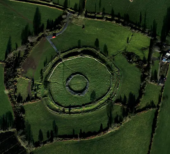
Encompassing the summit of Belmont Hill in undulating grassland. A large subcircular enclosure (N-S 170m, E-W 150m), in fair condition, defined by a bank and external fosse.
Full archaeological record 108 words
Encompassing the summit of Belmont Hill in undulating grassland. A large subcircular enclosure (N-S 170m, E-W 150m), in fair condition, defined by a bank and external fosse. Traces of an outer bank are visible beneath the modern stone wall which encloses the hill summit and Raftery (1976, 90) also noted traces of an outer fosse especially at S. An internal stone-facing is visible along the inner bank at E. There are entrances at S (Wth 5.5m) and W (Wth 3m), both with corresponding causeways across the fosse: Raftery (ibid., 90-91) suggests that the latter may be modern. A graveyard (GA015-016001-) is associated. (Costello 1902b, 109; Knox 1911a, 109)
Archaeological Survey of Ireland, National Monuments Service (CC BY 4.0) · Updated 05 August 2010 · Based on the Archaeological Inventory of County Galway Vol. II - North Galway'. Compiled by Olive Alcock, Kathy de hÓra and Paul Gosling. It describes the site as it was when surveyed.
Visitors' notes
Badges are opinions of visitors - not verified facts. One vote per badge and visitor; no account needed.
Best time to visit
What's missing on this page?
Share a tip to find it
Share a local tradition or story
Suggest a correction
Suggest the right map location
Report a duplicate page
Ask a question
Do not include personal data. See our privacy notice.
Around Belmont Hillfort
Other heritage nearby
- Feartagar CastleCastle · 5.6 km
Recorded within 5 km
- 36 ringfortsArchaeological Survey of Ireland
- 3 ancient churchesArchaeological Survey of Ireland
- 2 castlesArchaeological Survey of Ireland
- 1 monastic siteArchaeological Survey of Ireland
Walks and trails
- Castlegrove Woods trailWalking Trail · 1.5 km · nearest point 5.6 km
- Kilmaine - Killernan LoopWalking Trail · 5.1 km · nearest point 8.5 km
- Land of the GiantsWalking Trail · 4.2 km · nearest point 9.6 km
What's on nearby
- Travelling Banner Exhibition | Strangers to Citizens2027-01-13 · 12 km · free
Excavations nearby
- 12E0322 Gortnagunned, County GalwayRoad-scheme excavation report (TII) · 3.1 km
- 12E0323 Carrownurlaur, County GalwayRoad-scheme excavation report (TII) · 3.1 km